COMECAUSE IN_G30 Portable Canopy Image Analyzer
| Brand | COMECAUSE |
|---|---|
| Origin | Shandong, China |
| Manufacturer Type | Direct Manufacturer |
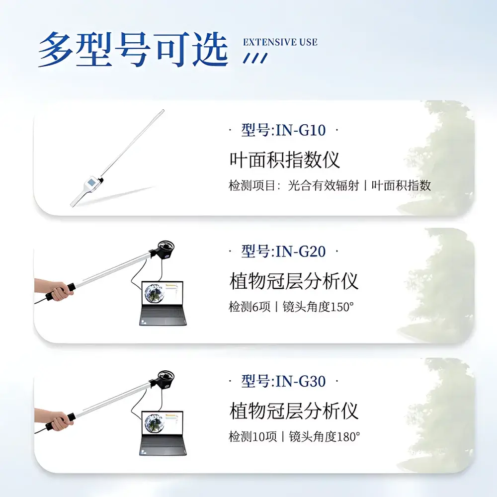
| Model | IN_G30 |
| Key Specifications | 180° fisheye lens |
| Image Resolution | 2592 × 1944 |
| PAR Spectral Range | 400–700 nm |
| PAR Measurement Range | 0–3000 µmol·m⁻²·s⁻¹ |
| Angular Coverage | Zenith angle 0°–90° (hemispherical), subdivided into 10 zenith zones & 10 azimuth zones |
| Operating Temperature | −10°C to 55°C |
| Relative Humidity | ≤85% RH |
| Weight | 500 g |
| Interface | USB |
| Software | COMECAUSE Canopy Analysis System v3.x |
| GPS Integration | Real-time geotagging (latitude/longitude) |
| Data Output | Cloud-sync capable (secure agricultural cloud platform) |
| Language Support | Switchable bilingual UI (English/Chinese) |
Overview
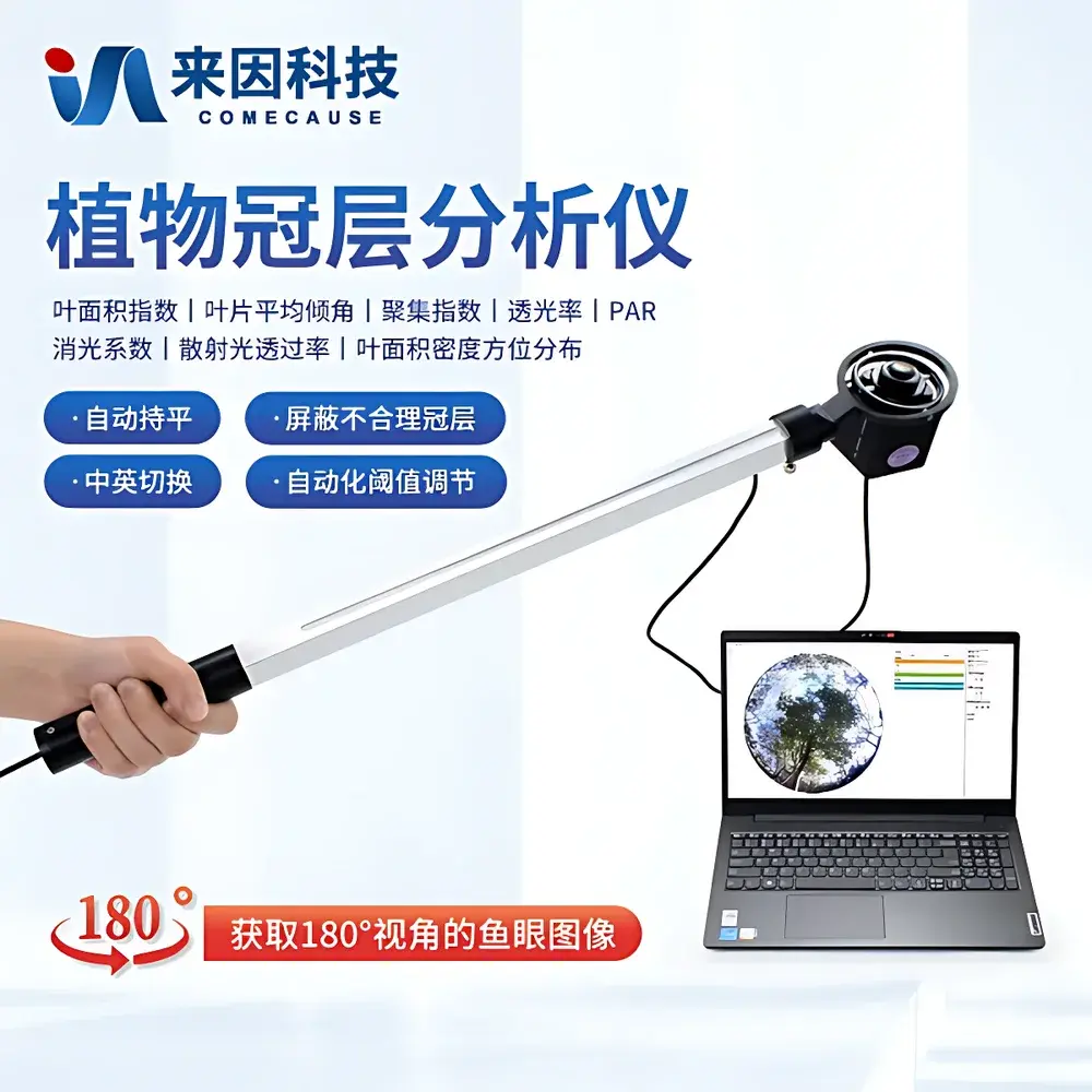
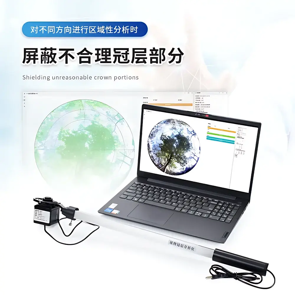
The COMECAUSE IN_G30 Portable Canopy Image Analyzer is an engineered field instrument designed for non-destructive, rapid quantification of structural and radiative properties of plant canopies. It operates on the principle of hemispherical photography—capturing upward-facing fisheye images of the sky through the canopy—and applies validated gap-fraction algorithms grounded in Beer-Lambert law assumptions and radiative transfer theory. By analyzing pixel-level light transmission across a 180° hemispherical field of view, the system computes spatially resolved canopy metrics critical for ecological modeling, agronomic decision support, and precision crop management. Unlike fixed-station sensors or destructive sampling methods, the IN_G30 enables repeatable, operator-independent measurements across heterogeneous stands—from orchards and vineyards to forest understories and cereal crop fields—without requiring permanent installation or calibration drift correction.
Key Features
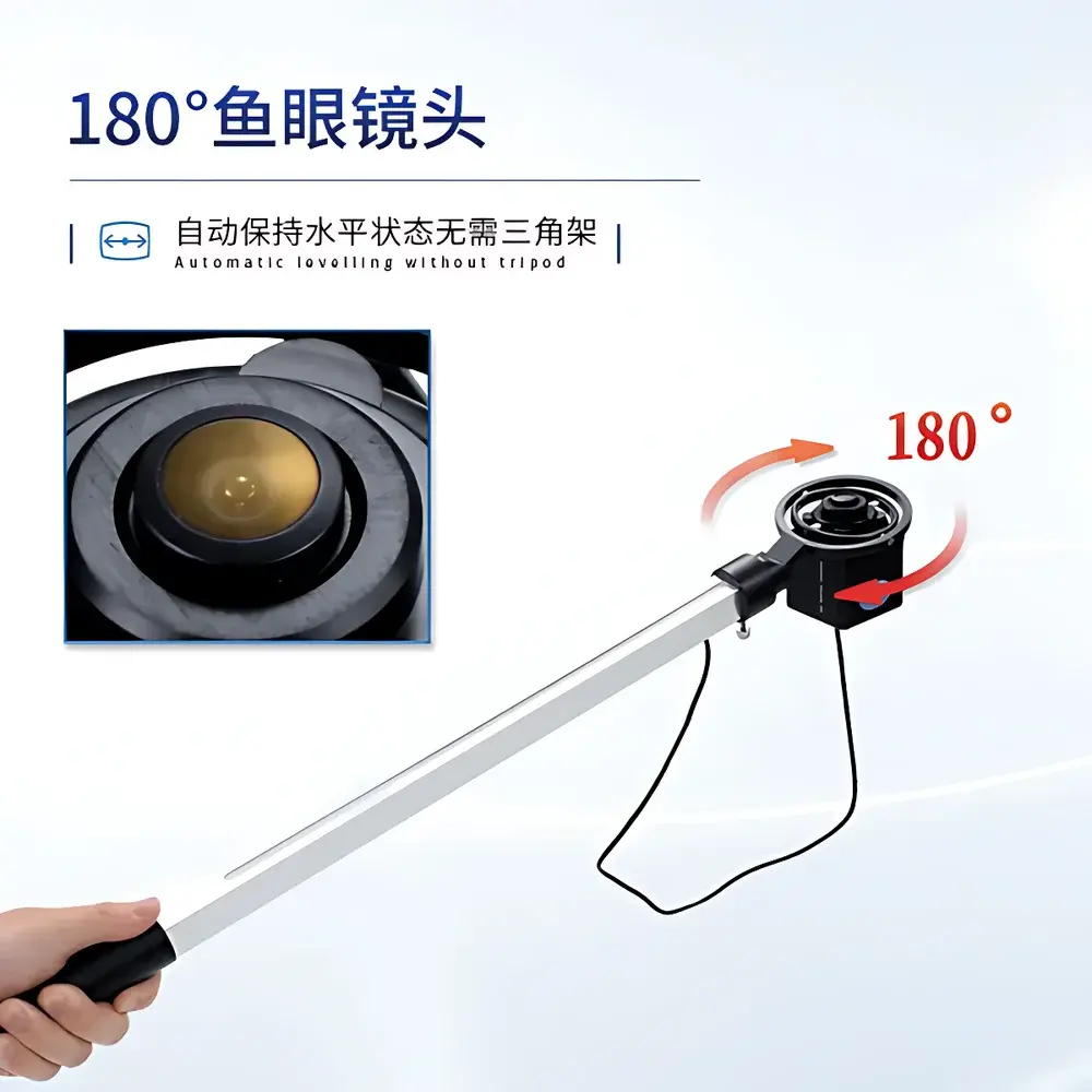
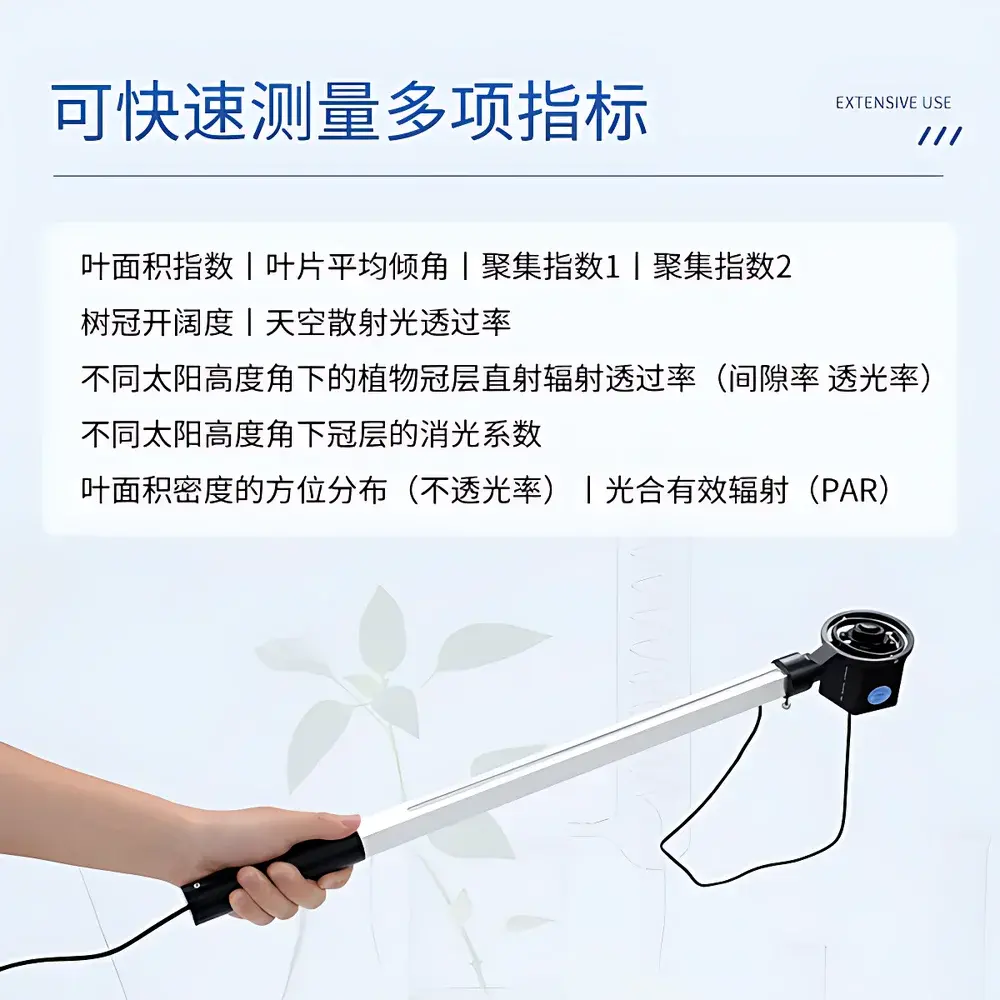
- Fisheye imaging probe with automatic horizon leveling: A compact, lightweight (500 g) fisheye lens mounted on a balanced gimbal arm ensures consistent image orientation without tripods—even on uneven terrain or within dense vegetation.
- Integrated PAR measurement rod: A dedicated measurement arm embeds 25 calibrated quantum sensors (400–700 nm), enabling concurrent acquisition of photosynthetically active radiation profiles alongside structural image data.
- Hemispherical image analysis at 2592 × 1944 resolution: High-fidelity capture supports robust thresholding and segmentation across ten zenith-angle bands (0°–90°) and ten azimuthal sectors (0°–360°), facilitating vertical and directional canopy architecture mapping.
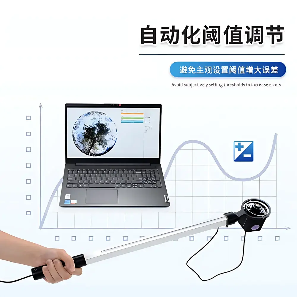
- Intelligent threshold optimization: Automated grayscale threshold selection minimizes user-induced bias during gap fraction calculation—critical for reproducible LAI and extinction coefficient derivation under variable lighting conditions.
- Real-time georeferencing: Integrated GPS module logs latitude, longitude, and timestamp with each measurement, ensuring traceability for longitudinal studies and GIS-based spatial analytics.
- Bilingual software interface (English/Chinese): Designed for international field teams and multilingual research consortia; language toggle requires no reinstallation or configuration changes.
Sample Compatibility & Compliance
The IN_G30 is compatible with herbaceous and woody vegetation across diverse growth stages and densities—including row crops (maize, soybean), perennial systems (grapevine, olive), agroforestry canopies, and natural shrublands. Its fisheye-based methodology conforms to ISO 11727:2022 (optical methods for canopy structure assessment) and aligns with FAO-recommended protocols for LAI validation. While not certified for GLP/GMP-regulated environments, the system supports audit-ready workflows: all raw images, processed outputs, and metadata are stored with immutable timestamps and geolocation tags. Exported datasets comply with CF Standard Format (Crop Field Data Interchange Specification) and are structured for direct ingestion into R, Python (scikit-image, rasterio), or commercial platforms such as ArcGIS Pro and CropSyst.
Software & Data Management
The COMECAUSE Canopy Analysis System (v3.x) provides a deterministic, scriptable analysis pipeline—from image preprocessing (lens distortion correction, vignetting compensation) to parameter extraction (LAI, clumping index, gap fraction, beam transmittance at specified solar zenith angles). Users define custom analysis zones via interactive polar grids, and exclude non-canopy pixels (e.g., soil gaps, equipment intrusion, edge effects) using polygon masking tools. All processing steps are logged in human-readable XML audit trails. Data export options include CSV (tabular metrics), GeoTIFF (spatialized LAI maps), and encrypted binary archives synchronized to the COMECAUSE Agricultural Cloud Platform—a secure, ISO/IEC 27001-aligned infrastructure supporting role-based access control, versioned dataset storage, and API-driven integration with farm management information systems (FMIS).
Applications
- Dynamic LAI monitoring for irrigation scheduling and nitrogen use efficiency modeling
- Canopy closure assessment in breeding trials to evaluate early vigor and competitive ability
- Light interception profiling to optimize intercropping configurations and planting density
- Forest structure characterization for carbon stock estimation and biodiversity indices
- Validation of radiative transfer models (e.g., SAIL, 4SAIL) and satellite-derived vegetation products (MODIS LAI, Sentinel-2 FAPAR)
- Teaching laboratories in plant ecology, agronomy, and remote sensing curricula
FAQ
Does the IN_G30 require external power sources in the field?
No—the fisheye probe and PAR rod operate passively; only the connected laptop requires power. Battery life depends on host device specifications.
Can the system measure under overcast conditions?
Yes. The fisheye imaging method remains valid under diffuse light; however, direct-beam transmittance calculations require simultaneous solar position data, which the integrated GPS + real-time clock provides.
Is raw image data accessible for third-party analysis?
Yes. Unprocessed TIFF files and associated EXIF metadata (including GPS, time, lens parameters) are fully exportable and retain full bit-depth fidelity.
How is PAR sensor calibration maintained?
Each unit ships with NIST-traceable calibration certificates. Field recalibration is not required within the first 24 months; annual verification against a reference quantum sensor is recommended per ISO 9060:2018 Class C guidelines.
What cloud security standards does the COMECAUSE Agricultural Cloud Platform meet?
Data transmission uses TLS 1.3 encryption; at-rest storage complies with AES-256 encryption standards. Platform architecture adheres to ISO/IEC 27001:2022 Annex A controls for access management, incident response, and vulnerability disclosure.