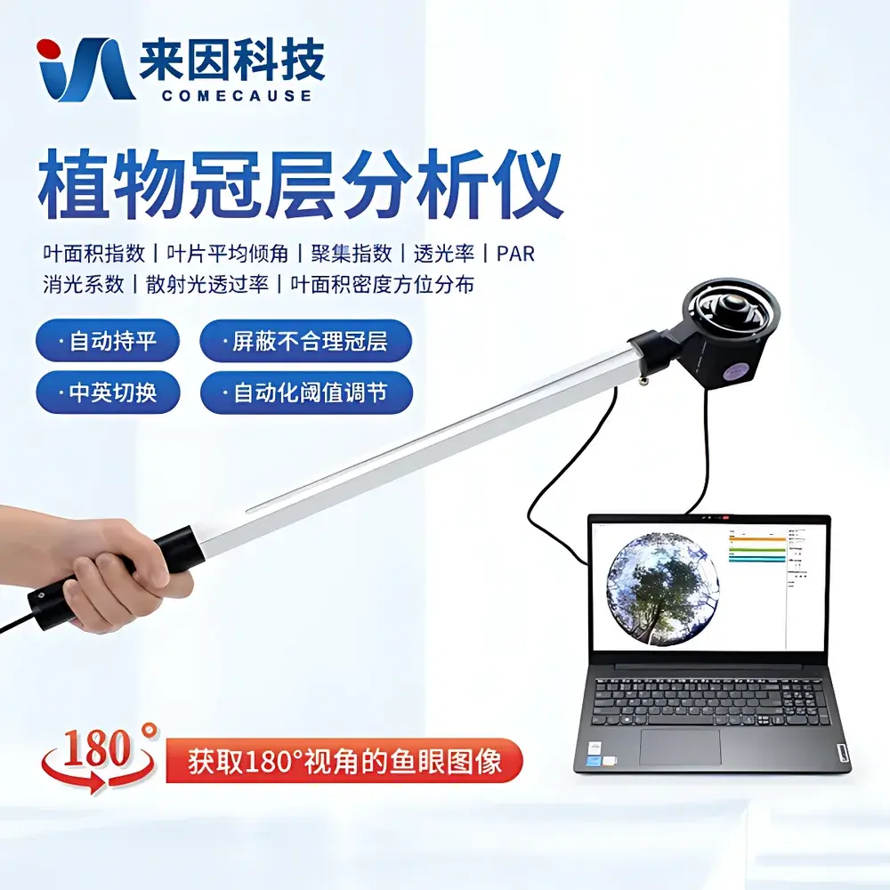
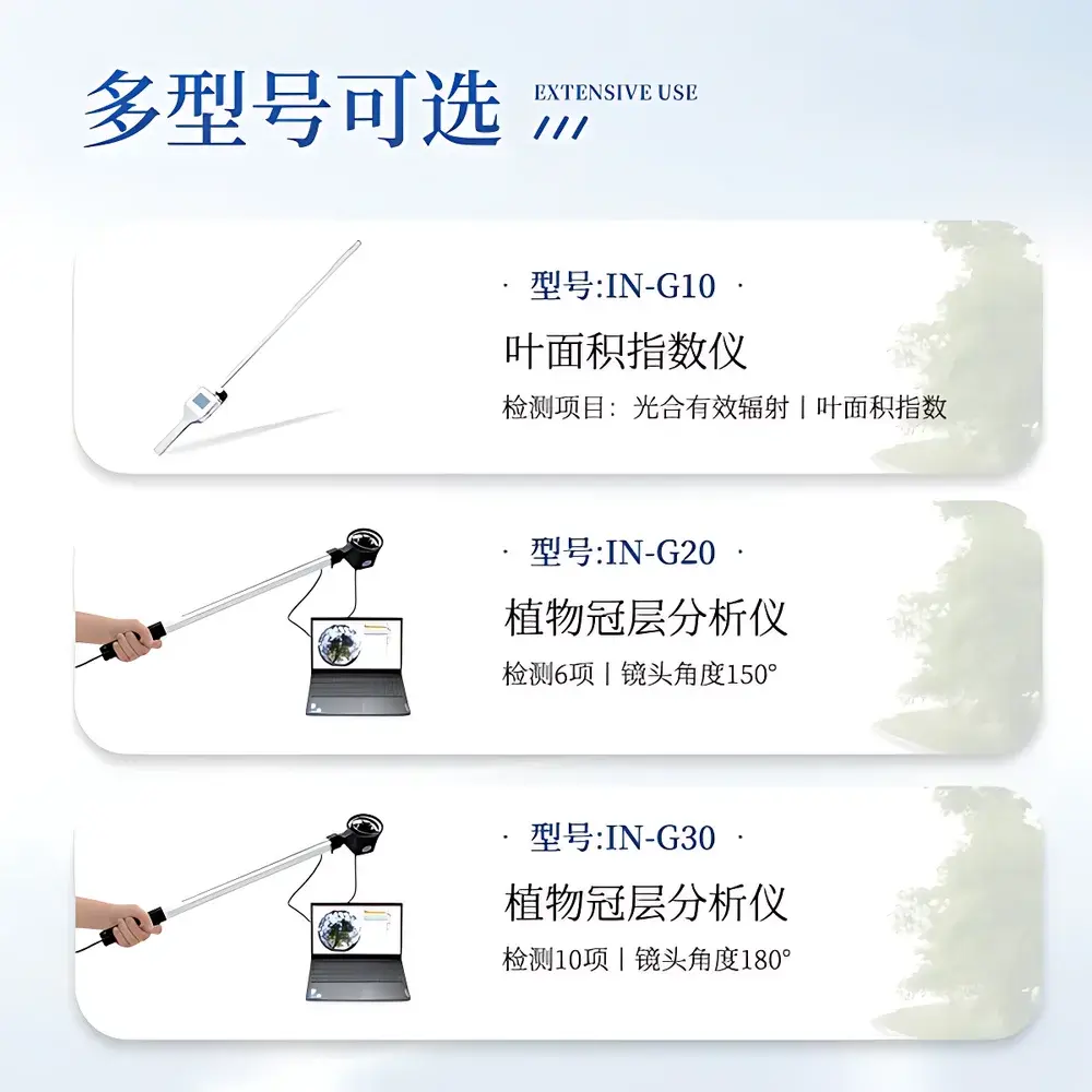
COMECAUSE IN/G30 Canopy Analyzer
| Brand | COMECAUSE |
|---|---|
| Origin | Shandong, China |
| Manufacturer Type | Direct Manufacturer |
| Model | IN/G30 |
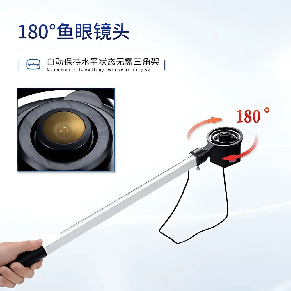
| Field-of-View | 180° fisheye |
| Image Resolution | 2592 × 1944 |
| PAR Spectral Range | 400–700 nm |
| PAR Measurement Range | 0–3000 µmol·m⁻²·s⁻¹ |
| Angular Partitioning | Zenith angle 0°–90° (10 zones), Azimuth 0°–360° (10 zones) |
| Operating Temperature | −10°C to +55°C |
| Relative Humidity | ≤85% RH |
| Weight | 500 g |
| Interface | USB 2.0 |
| Software | COMECAUSE Canopy Analysis System v3.x |
| GPS Integration | Built-in GNSS module (latitude/longitude logging) |
| Data Export | Cloud-synchronized upload to COMECAUSE AgriCloud Platform |
| Language Support | Switchable English/Chinese UI |
Overview
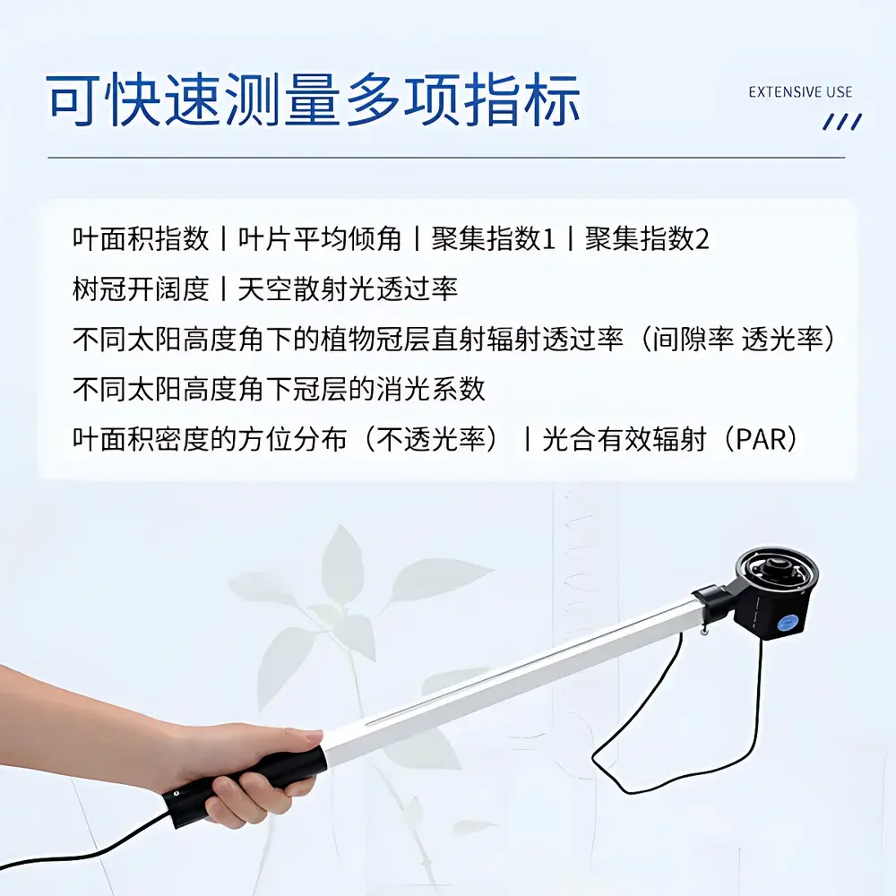
The COMECAUSE IN/G30 Canopy Analyzer is a field-deployable, semi-automated optical instrument engineered for quantitative structural and radiative characterization of plant canopies. It operates on the widely accepted gap fraction theory—grounded in Beer-Lambert law principles—where canopy light interception is modeled as a function of spatially distributed gaps within the foliage layer. By capturing hemispherical (180° fisheye) images from beneath the canopy and coupling them with concurrent photosynthetically active radiation (PAR) measurements across 25 calibrated sensors mounted on a telescoping measurement arm, the system enables simultaneous derivation of structural parameters—including leaf area index (LAI), clumping index (CI), canopy openness, extinction coefficient (k), and azimuthal LAI distribution—as well as radiation transmission profiles under varying solar zenith angles. Designed for rigorous ecological and agronomic fieldwork, the IN/G30 meets operational requirements for reproducible, location-tagged canopy assessment without reliance on external tripods or manual leveling.
Key Features
- Fisheye imaging probe with automatic horizon-leveling gimbal mount—eliminates need for tripod stabilization and ensures geometrically consistent hemispherical image acquisition across uneven terrain.
- Integrated 25-sensor PAR measurement arm (telescoping design) enabling vertical profiling of light attenuation through stratified canopy layers; supports height-resolved LAI and k-value estimation.
- High-resolution CMOS sensor (2592 × 1944 pixels) optimized for contrast-based gap detection under variable ambient lighting conditions.
- Configurable angular partitioning: zenith angle segmented into 10 discrete bands (0°–90°), azimuth into 10 sectors (0°–360°), allowing directional analysis of canopy heterogeneity and anisotropic light transmission.
- Real-time GNSS geotagging embedded at acquisition level—each image and associated PAR dataset carries precise latitude/longitude metadata compliant with FAO GeoNetwork and ISO 19115 metadata standards.
- Adaptive thresholding algorithm for gap identification—minimizes user-induced bias by dynamically optimizing binary segmentation based on local histogram statistics rather than fixed global thresholds.
- Cloud-integrated data pipeline: encrypted USB transfer to laptop preloaded with COMECAUSE Canopy Analysis System v3.x, followed by optional automated sync to AgriCloud—a secure, ISO/IEC 27001-aligned platform supporting multi-user access control and audit-trail logging per GLP requirements.
Sample Compatibility & Compliance
The IN/G30 is validated for use across diverse vegetation types—including row crops (maize, soybean), orchards (apple, citrus), forest understory, and grassland ecosystems. Its non-destructive, ground-based methodology aligns with ASTM E2913-22 (Standard Guide for Digital Hemispherical Photography in Vegetation Studies) and supports protocols referenced in USDA ARS Technical Bulletin No. 1939. The PAR sensor array complies with ISO 17166:2019 (CIE S 026/E:2019) spectral responsivity specifications for photosynthetic photon flux density (PPFD) measurement. All firmware and software modules undergo periodic validation against NIST-traceable PAR reference sources. Device operation conforms to IEC 60529 IP54 environmental rating for field instrumentation.
Software & Data Management
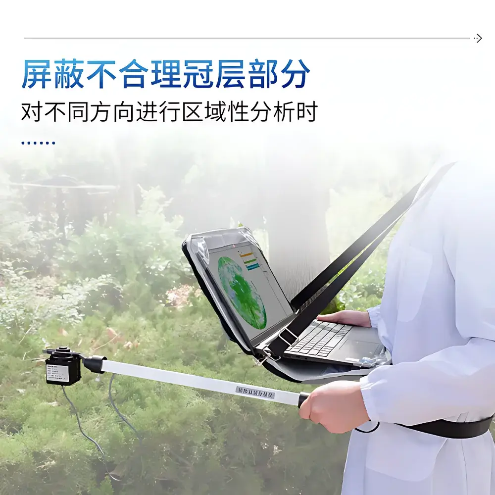
The COMECAUSE Canopy Analysis System v3.x is a Windows-based desktop application supporting batch processing of fisheye images and synchronized PAR time-series. Core analytical functions include customizable region-of-interest (ROI) masking—enabling exclusion of edge effects, gaps due to missing plants, or non-canopy obstructions—and iterative LAI inversion using the modified Beer-Lambert model incorporating CI correction. Export formats include CSV (tabular parameter sets), GeoTIFF (georeferenced canopy transmittance maps), and XML metadata bundles compliant with Darwin Core standards. Audit trails record operator ID, timestamp, GPS coordinates, software version, and processing parameters—meeting FDA 21 CFR Part 11 requirements for electronic records in regulated agricultural research environments.
Applications
- Dynamic monitoring of LAI during crop growth stages to inform nitrogen management decisions and optimize fertilizer application timing.
- Evaluation of canopy architecture responses to drought stress, pruning regimes, or breeding selections in perennial horticulture systems.
- Validation of radiative transfer models used in satellite-based vegetation index scaling (e.g., MODIS LAI product calibration).
- Long-term ecological studies assessing canopy closure rates in afforestation projects or invasive species encroachment dynamics.
- Supporting precision irrigation scheduling via real-time PAR interception mapping across heterogeneous field zones.
FAQ
Does the IN/G30 require external calibration before each measurement?
No. The fisheye lens is factory-calibrated for distortion correction, and PAR sensors are pre-trimmed against NIST-traceable irradiance standards. A single annual verification using the included reference diffuser is recommended per ISO/IEC 17025 guidelines.
Can the system operate under full overcast conditions?
Yes. The 400–700 nm PAR sensors maintain linearity across diffuse-dominant irradiance conditions, and gap fraction analysis remains valid as long as sufficient contrast exists between sky and foliage elements in the fisheye image.
Is raw image data accessible for third-party analysis?
Yes. Unprocessed TIFF images and uncorrected PAR voltage logs are stored locally and exportable via USB; no proprietary encryption restricts access to native sensor outputs.
How is cloud data security managed?
AgriCloud employs TLS 1.3 encryption in transit and AES-256 at rest. Account-level permissions follow role-based access control (RBAC), and all data modifications generate immutable audit entries timestamped to UTC and signed with hardware-backed keys.
What is the battery life of the measurement arm and probe?
The integrated lithium-polymer battery supports ≥8 hours of continuous operation at 25°C. Power consumption is monitored in real time via the software interface, with low-battery alerts issued at 15% remaining capacity.