Ecodrone® High-Resolution Thermo-RGB UAV Remote Sensing System
| Origin | Czech Republic |
|---|---|
| Manufacturer Type | Authorized Distributor |
| Origin Category | Imported |
| Model | Ecodrone® |
| Pricing | Upon Request |
Overview
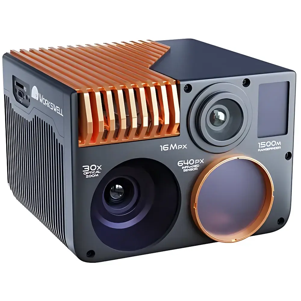
The Ecodrone® High-Resolution Thermo-RGB UAV Remote Sensing System is a turnkey aerial remote sensing platform engineered for scientific-grade environmental and ecological monitoring. Built around the proprietary UAS-4 or UAS-4 Pro unmanned aerial system, it integrates the WIRIS Enterprise multispectral imaging sensor—combining long-wave infrared (LWIR) thermal imaging, 16-megapixel RGB photogrammetry, 30× optical zoom with electronic image stabilization, and 1500 m laser rangefinding into a single synchronized payload. The system operates on the principle of concurrent multi-sensor data acquisition under precise georeferenced flight control, enabling pixel-aligned thermal-radiometric, visible-spectrum, and geometric distance measurements in a single overflight. Designed for field-deployable robustness, it meets IP66 ingress protection standards and supports operation across ambient temperatures from −15 °C to +50 °C—making it suitable for year-round deployment in diverse biogeographic zones, from alpine forests to arid steppe ecosystems.
Key Features
- Proprietary UAS-4 lightweight UAV platform, certified with the “Houji Award” at the 24th Yangling Agricultural Hi-Tech Fair for innovation in agricultural remote sensing
- Synchronized multi-sensor acquisition: LWIR thermal imaging (640 × 512 native / 1266 × 1010 super-resolved), 16 Mpx RGB imaging (4656 × 3496), 30× optically stabilized zoom lens, and 1500 m laser distance measurement—all time-stamped and spatially registered
- Centimeter-level ground sampling distance (GSD): 1.6 cm at 50 m altitude for RGB; 6.5 cm at 45° FOV for LWIR thermal imagery
- Modular sensor configuration: Optional integration of 5-band or 10-band multispectral cameras compatible with NDVI, NDRE, and other vegetation indices
- Magnet-encoded gimbal with real-time attitude compensation ensures sub-pixel image stability during dynamic flight maneuvers
- Onboard high-speed SSD (128 GB or 256 GB standard) with dual external storage support (microSD + USB) for redundant radiometric and visual data capture
Sample Compatibility & Compliance
The system is designed for non-contact, wide-area surface characterization without sample preparation. It supports direct measurement of emissivity-corrected surface temperatures, reflectance-derived vegetation health metrics, and topographic elevation via laser ranging. All thermal calibration routines comply with ISO 18434-1 (Condition monitoring — Thermography) and ASTM E1934-19 (Standard Guide for Examining Electrical and Mechanical Equipment with Infrared Thermography). Radiometric TIFF and JPEG outputs are fully compatible with photogrammetric processing workflows adhering to ASPRS accuracy standards and meet metadata requirements for FAO’s WaPOR and ESA’s Copernicus Land Monitoring Program ingestion protocols. The onboard operating system logs full audit trails—including NUC trigger events, gain mode selection, and temperature range settings—supporting GLP-compliant data provenance.
Software & Data Management
WIRIS Enterprise firmware provides full onboard control via intuitive GUI or programmable API (REST/HTTP). Radiometric video streams (30 Hz or 9 Hz raw thermal frames) and synchronized JPEG/TIFF imagery are stored with embedded EXIF and XMP metadata, including GPS position, IMU orientation, barometric altitude, and calibrated radiance values. Export formats include Pix4D-compatible radiometric TIFFs and Agisoft Metashape-ready JPEG sequences. Post-processing supports emissivity correction, atmospheric compensation (using MODTRAN-based models), and thermal anomaly detection via user-defined threshold logic (Above/Below/Between modes). All captured datasets retain traceable timestamps aligned to UTC via GNSS PPS synchronization, fulfilling requirements for FDA 21 CFR Part 11–compliant audit trails in regulated environmental assessment applications.
Applications
- Wildlife census and habitat mapping in protected areas using thermal contrast segmentation
- Early-stage forest fire detection through sub-canopy thermal anomaly identification
- Post-wildfire burn severity assessment via normalized burn ratio (NBR) derived from co-registered RGB and LWIR bands
- Power transmission line inspection for hot-spot detection in insulators and connectors
- Precision agriculture: canopy temperature differentials (CTD), water stress indexing (CWSI), and yield prediction modeling
- Archaeological prospection via thermal inertia mapping of subsurface features
- Urban heat island (UHI) studies with spatially explicit land surface temperature (LST) grids
- Coastal wetland health monitoring using combined thermal emissivity and vegetation index analysis
FAQ
What regulatory certifications does the WIRIS Enterprise sensor hold?
The sensor complies with CE marking requirements for electromagnetic compatibility (EMC Directive 2014/30/EU) and radio equipment (RED Directive 2014/53/EU). Thermal calibration traceability follows ISO/IEC 17025-accredited laboratory practices.
Is the system compatible with third-party flight planning software?
Yes—it supports MAVLink protocol integration with QGroundControl, Mission Planner, and UgCS for automated grid, corridor, and waypoint-based survey missions.
Can radiometric data be exported for quantitative thermal analysis?
Yes—raw thermal frames are saved as 16-bit radiometric TIFFs containing absolute radiance values (W·sr⁻¹·m⁻²), enabling pixel-wise temperature retrieval using Planck’s law and user-defined emissivity parameters.
Does the system support real-time downlink of thermal imagery?
Optional telemetry modules enable low-latency H.264 streaming of processed thermal overlays to ground control stations, though full radiometric fidelity is retained only in onboard recordings.
What is the maximum operational altitude above ground level (AGL)?
Certified for sustained operations up to 120 m AGL under EASA SORA-compliant scenarios; higher altitudes require national aviation authority authorization based on local UAV regulations.
Related Products


