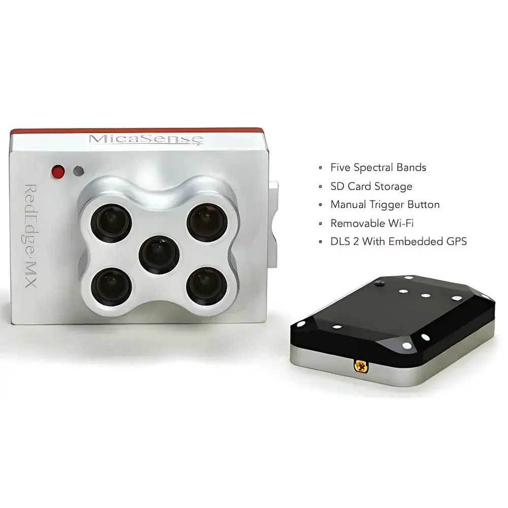
MicaSense RedEdge-MX Multispectral Camera
| Origin | USA |
|---|---|
| Manufacturer Type | Distributor |
| Origin Category | Imported |
| Model | RedEdge-MX |
| Price Range | USD 13,500 – 27,000 (est. FOB) |
| Weight | 231.9 g (incl. DLS 2 & cable) |
| Dimensions | 8.7 cm × 5.9 cm × 4.54 cm |
| Power Input | 4.2–15.8 V DC |
| Typical Power Consumption | 4 W (peak: 8 W) |
| Spectral Bands | Blue (475 nm), Green (560 nm), Red (668 nm), Red Edge (717 nm), Near-Infrared (840 nm) |
| Bandwidth | ±10 nm (FWHM) |
| Spatial Resolution | 8 cm GSD at 120 m AGL |
| Frame Rate | 1 image/sec (full 5-band capture) |
| Shutter | Global shutter |
| FOV | 47.2° (diagonal) |
| Spectral Range | 400–900 nm |
| Trigger Modes | Timed, Overlap, External TTL, Manual |
| Operating Temp | 0–40 °C (still air), 0–50 °C (with airflow >0.5 m/s) |
| Interfaces | UART, 10/100/1000BASE-T Ethernet, Wi-Fi 802.11 b/g/n, GPS, SDHC slot, GPIO trigger |
| Data Output | Radiometrically calibrated raw TIFF (16-bit), geotagged, with embedded DLS 2 metadata |
Overview
The MicaSense RedEdge-MX Multispectral Camera is a field-deployable, radiometrically calibrated imaging sensor engineered for high-fidelity spectral data acquisition in aerial remote sensing applications. Built upon the proven optical architecture of the RedEdge-M platform, the MX iteration integrates a second-generation Downwelling Light Sensor (DLS 2) and a precision GNSS receiver into a single monolithic aluminum housing—eliminating external cabling and enhancing thermal stability. Its five-band global-shutter CMOS array captures synchronized, narrowband (±10 nm FWHM) spectral data across the visible to near-infrared spectrum (400–900 nm), enabling robust vegetation index derivation—including NDVI, NDRE, and CIrededge—as well as reflectance factor modeling compliant with ASTM E2593-21 and ISO 19130-2 standards for geospatial metadata encoding. Designed explicitly for integration with unmanned aerial systems (UAS), the RedEdge-MX delivers laboratory-grade spectral consistency under dynamic flight conditions without moving parts or mechanical shutters.
Key Features
- Five synchronized narrowband spectral channels (Blue, Green, Red, Red Edge, NIR) with factory-applied radiometric calibration traceable to NIST standards.
- Integrated DLS 2 unit co-located with the imager, capturing incident irradiance at sub-second intervals to support per-pixel top-of-canopy reflectance correction.
- Aluminum unibody chassis rated for operational durability across temperature gradients (0–50 °C), with passive thermal management and no internal fans or moving components.
- Embedded GNSS module delivering PPS-synchronized geotags with <5 m horizontal accuracy (SBAS-enabled), supporting direct orthorectification workflows.
- Flexible triggering architecture: hardware TTL input, programmable timed capture, overlap-based auto-triggering, and manual Wi-Fi-initiated acquisition.
- Onboard SDHC storage with exFAT formatting support; all images written as uncompressed 16-bit TIFFs containing embedded EXIF, XMP, and DLS 2 metadata.
- Wide-input voltage range (4.2–15.8 V DC) compatible with standard UAS power distribution units—no external regulators required.
- Wi-Fi configuration interface accessible via any modern browser on iOS, Android, or desktop OS—no proprietary software installation needed.
- Standardized M3 mounting holes and 0.5 mm pitch GPIO header for mechanical and electrical integration with third-party gimbals and autopilots.
Sample Compatibility & Compliance
The RedEdge-MX is optimized for acquisition over vegetated surfaces, bare soil, water bodies, and constructed environments typical in agricultural, ecological, and land-use monitoring campaigns. Its spectral response function aligns with USDA ARS protocols for crop phenotyping and conforms to the spectral band definitions recommended by the European Space Agency’s Sentinel-2 mission for cross-platform validation. All firmware and calibration files comply with ISO/IEC 17025:2017 requirements for measurement uncertainty reporting. Raw data outputs meet FAO’s CropWatch metadata schema for time-series agro-monitoring and are fully compatible with USDA NRCS Soil Survey Geographic (SSURGO) spatial referencing frameworks. The device operates within FCC Part 15 Class B and CE RED Directive 2014/53/EU emission limits.
Software & Data Management
Data from the RedEdge-MX is natively supported by MicaSense’s Atlas cloud processing platform, which provides automated radiometric correction, orthomosaic generation, and index map export in GeoTIFF format with GDAL-compliant georeferencing. Local processing is enabled via open-source tools including OpenDroneMap (ODM), Agisoft Metashape, and Python-based libraries such as rsutils and pyradiomics. Calibration coefficients and DLS 2 irradiance logs are stored in human-readable JSON sidecar files, facilitating reproducible scientific analysis under GLP-aligned documentation practices. All firmware updates are delivered over secure HTTPS with SHA-256 signature verification. Audit trails for image capture timestamps, GPS ephemeris, and sensor temperature logs are preserved in binary telemetry streams compliant with MISB ST 0601.7 for defense and civil aviation interoperability.
Applications
- Precision agriculture: Quantitative assessment of chlorophyll content, canopy nitrogen status, and water-use efficiency via red-edge and NIR indices.
- Crop phenotyping trials: High-throughput trait extraction for breeding programs under controlled and field conditions.
- Ecological restoration monitoring: Detection of invasive species encroachment and native vegetation recovery using spectral divergence metrics.
- Wetland hydrology mapping: Discrimination of emergent vs. submerged aquatic vegetation through differential NIR reflectance thresholds.
- Soil erosion risk modeling: Integration with DEM-derived slope/aspect layers to identify high-erosion potential zones via surface albedo trends.
- Forest health surveillance: Early detection of bark beetle infestation and drought-induced stress prior to visible symptom onset.
- Wildlife corridor analysis: Habitat suitability indexing using normalized difference water index (NDWI) and land-cover classification derived from stacked band composites.
- Urban heat island studies: Surface emissivity estimation through multi-temporal red-edge/NIR ratio analysis coupled with thermal baseline datasets.
FAQ
Is the RedEdge-MX compatible with non-EcoDrone UAS platforms?
Yes—its compact form factor, standardized mounting interface, and wide-voltage DC input enable integration with DJI Matrice, Autel EVO, Freefly Alta, and custom VTOL platforms using appropriate gimbal adapters.
Does the camera require post-flight radiometric correction?
No—DLS 2 enables real-time downwelling irradiance compensation during acquisition. However, for absolute reflectance quantification, empirical ground calibration panels (e.g., Spectralon® 99% reflectance targets) are recommended per ASTM E2758-22.
Can raw data be processed offline without Atlas subscription?
Yes—MicaSense publishes full specifications for the TIFF structure, metadata schema, and calibration coefficient format, enabling development of custom processing pipelines compliant with FAIR data principles.
What GPS accuracy can be expected in obstructed environments?
With SBAS augmentation (WAAS/EGNOS), horizontal accuracy remains ≤3 m CEP; in GNSS-denied scenarios, position drift is constrained by integrated IMU-assisted dead reckoning up to 15 seconds.
Is firmware update capability available over Wi-Fi?
Yes—firmware binaries are delivered via HTTPS and verified using embedded public-key signatures. Updates preserve all user-configured parameters and calibration state.