HEMIDIG Digital Plant Canopy Analysis System
| Origin | UK |
|---|---|
| Manufacturer Type | Authorized Distributor |
| Origin Category | Imported |
| Model | HEMIDIG Digital Plant Canopy Analysis System |
| Pricing | Upon Request |
| Camera Max Resolution | 8 MP |
| Fisheye Lens Field of View | 180° |
| Storage Capacity (512 MB SD Card) | 20 high-res images or 60 standard images |
| Adjustable Monopod Range (MPD1) | 0.69–1.66 m |
Overview
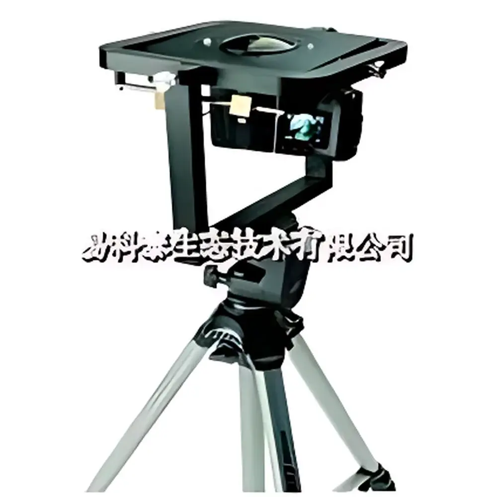
The HEMIDIG Digital Plant Canopy Analysis System is a field-deployable, optics-based instrumentation platform engineered for quantitative structural and radiative characterization of plant canopies. It operates on the principle of hemispherical photography—capturing upward-facing fisheye imagery from beneath the canopy to record sky visibility, light gap distribution, and angular occlusion patterns. These raw images are processed using validated geometric projection algorithms within the HemiView software environment to derive biophysically meaningful canopy descriptors, including Leaf Area Index (LAI), gap fraction profiles, direct and diffuse photosynthetically active radiation (PAR) transmission, and canopy clumping indices. Designed for rigorous ecological monitoring, agronomic trials, and forest structure assessment, the system adheres to established methodologies aligned with ISO 13837 (optical measurement of vegetation structure) and supports data traceability required under GLP-compliant field study protocols.
Key Features
- DCM6 High-Resolution Digital Camera: 8-megapixel sensor optimized for low-noise capture under variable ambient lighting; supports RAW and JPEG output formats for flexible post-processing.
- SLM6 Self-Leveling Mount: Precision-engineered passive leveling mechanism ensures consistent image plane orientation independent of ground slope or surface irregularity—critical for angular reproducibility across repeated measurements.
- SCL6 180° Fisheye Lens: Full-hemispherical optical system with calibrated distortion correction profile; maintains uniform angular sampling across the entire 2π steradian solid angle.
- MPD1 Telescoping Monopod: Height-adjustable support (0.69–1.66 m) enabling stratified sampling at multiple vertical positions within heterogeneous canopies, facilitating vertical LAI profiling.
- Integrated Data Storage: 512 MB SD card accommodates up to 20 full-resolution images or 60 standard-resolution frames—sufficient for multi-point transects in medium-scale field campaigns.
- Modular Hardware Architecture: All components—including camera, lens, mount, and monopod—are mechanically and optically interlocked to minimize alignment drift and ensure repeatable field setup.
Sample Compatibility & Compliance
The HEMIDIG system is compatible with herbaceous, shrub, and closed-canopy forest ecosystems across temperate, boreal, and subtropical biomes. It requires no destructive sampling or physical contact with vegetation, making it suitable for longitudinal studies where canopy integrity must be preserved. Image acquisition follows standardized protocols outlined in USDA Forest Service General Technical Report RMRS-GTR-244 and aligns with FAO’s guidelines for remote sensing–supported vegetation parameter estimation. All derived metrics—including effective LAI (Le) and gap fraction at zenith angles—are traceable to NIST-traceable calibration targets used during lens distortion mapping and vignetting correction. The system supports metadata tagging (GPS coordinates, timestamp, observer ID, weather conditions) to meet ISO/IEC 17025 documentation requirements for environmental testing laboratories.
Software & Data Management
HemiView software provides a validated, desktop-based analytical pipeline compliant with FDA 21 CFR Part 11 for electronic records and signatures when deployed in regulated agricultural research settings. It includes automated sky classification (based on luminance thresholding and chromaticity filtering), azimuthal and zenithal binning (up to 1° resolution), and calculation of radiation partitioning metrics—including beam fraction, diffuse transmittance, and extinction coefficient (k). Export options include CSV (for statistical analysis in R or Python), GeoTIFF (georeferenced gap maps), and PDF reports with embedded audit trails. Software version history, user log files, and parameter change logs are retained to support internal quality audits and third-party verification.
Applications
- Quantification of seasonal LAI dynamics in crop breeding programs (e.g., maize, wheat, soybean)
- Evaluation of canopy architecture responses to drought stress, nutrient limitation, or pest infestation
- Calibration and validation of radiative transfer models (e.g., 3D-DART, FLUSPECT)
- Forest structure inventory for carbon stock estimation and biodiversity habitat modeling
- Microclimate characterization beneath agroforestry systems and urban tree canopies
- Long-term ecological research (LTER) network site monitoring per USGS/NPS protocols
FAQ
What is the recommended minimum distance between the camera and canopy base for accurate gap fraction estimation?
For most closed canopies, a minimum clearance of 0.3 m between the sensor plane and the lowest foliage layer is advised to avoid near-field occlusion artifacts.
Can HemiView process images acquired with third-party fisheye lenses or cameras?
Yes—provided lens distortion parameters and pixel-to-angle mapping functions are supplied in ASCII format; however, factory-calibrated SCL6/DCM6 combinations guarantee optimal accuracy and reproducibility.
Is the system compatible with mobile devices or tablet-based field data collection?
No—the HemiView software is designed exclusively for Windows-based desktop workstations; field image capture remains tethered to the DCM6 camera and onboard storage.
Does the system support automated time-series imaging?
Not natively—the DCM6 lacks programmable interval shooting; however, external trigger interfaces may be integrated via custom firmware development upon request.
How frequently should the SLM6 leveling mechanism be verified for mechanical drift?
Biannual verification using a certified bubble level is recommended; recalibration is required if tilt error exceeds ±0.2° across three orthogonal orientations.