EcoTech Field Intelligent Inspection Robot Phenotyping Platform
| Brand | EcoTech |
|---|---|
| Origin | Beijing, China |
| Manufacturer Type | Authorized Distributor |
| Country of Origin | China |
| Model | EcoTech |
| Pricing | Upon Request |
Overview
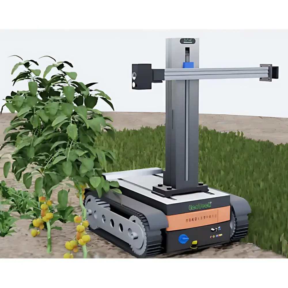
The EcoTech Field Intelligent Inspection Robot Phenotyping Platform is a fully autonomous, in-situ plant phenotyping system engineered for high-throughput, non-destructive, and multi-modal field-scale analysis. Built on a rugged履带-based mobile robot platform integrated with real-time kinematic (RTK) GNSS navigation (dual-mode GNSS, 5 cm positional accuracy), the system enables precise georeferenced data acquisition across heterogeneous agricultural terrain. Unlike conventional RGB-only inspection robots, this platform implements a synergistic sensor fusion architecture combining three proprietary imaging modalities: FluorTronn® chlorophyll fluorescence imaging (a nationally recognized major agricultural innovation), multi-functional hyperspectral imaging (awarded the “Houji Award” at Yangling Agricultural Hi-Tech Fair), and Thermo-RGB imaging—integrating thermal infrared, visible RGB, and pixel-level fused analysis. The system operates on the principle of spatially resolved optical biophysics: chlorophyll fluorescence parameters report on photosynthetic efficiency and stress-induced electron transport disruption; hyperspectral reflectance indices quantify pigment composition, canopy structure, water status, nitrogen content, and secondary metabolite accumulation; thermal imaging captures stomatal conductance proxies via canopy-to-air temperature differentials (Tc–Ta). All measurements are performed under natural illumination conditions, preserving ecological validity while enabling longitudinal monitoring across growth stages.
Key Features
- Patented field robot phenotyping technology (Chinese Utility Model ZL 2020 2 1174397.3)
- Modular sensor payload configuration: selectable combinations of hyperspectral imaging (VIS–NIR or SWIR bands), FluorTronn® chlorophyll fluorescence imaging (including LED-induced fluorescence monitoring and full-frame fluorescence imaging), and Thermo-RGB imaging (with sub-pixel thermal–RGB co-registration)
- XYZ triaxial automated scanning mechanism: supports both top-down canopy imaging and side-view profiling—critical for morphological assessment of upright, vining, or rosette-type crops
- RTK-enhanced navigation: dual-band GNSS receiver with centimeter-level positioning repeatability; supports pre-programmed autonomous mission planning and real-time trajectory correction
- Robust locomotion system: tracked chassis with zero-radius turning capability, 15 cm obstacle clearance, integrated shock absorption, and puncture-resistant treads optimized for muddy, uneven, or debris-laden field surfaces
- Extended operational endurance: high-capacity Li-ion battery pack enabling full-day continuous operation under variable solar loading and ambient temperatures
- Remote ground station control: open-architecture telemetry interface with dual-redundant fail-safe radio link (5 km range); supports voice feedback, live telemetry overlay, and GIS-integrated mission visualization
- Expandable sensor ecosystem: built-in environmental sensors (ambient temperature, relative humidity, PAR irradiance); provision for third-party add-ons including soil moisture probes, CO₂ analyzers, or acoustic emission modules
Sample Compatibility & Compliance
The platform is validated for in-situ phenotyping of diverse crop species—including but not limited to maize, wheat, rice, tomato, lettuce, soybean, and forage grasses—across field, greenhouse, and nursery environments. It accommodates plants ranging from seedlings (e.g., tomato cotyledon stage) to mature canopies exceeding 2 m height. All imaging protocols comply with FAO-recommended field phenotyping standards and align with OECD consensus guidelines for non-destructive physiological trait measurement. Data acquisition workflows support audit-ready documentation per GLP principles, with timestamped, geotagged metadata embedded in every image file. Software export formats (GeoTIFF, ENVI BIL, HDF5) ensure interoperability with common agronomic modeling platforms (e.g., APSIM, DSSAT) and statistical analysis suites (R, Python SciPy stack).
Software & Data Management
Two domain-specific software suites drive analytical rigor: SpectrAPP for hyperspectral phenotyping and FluorVision for fluorescence quantification. Both applications implement ISO/IEC 17025-aligned calibration traceability, ROI-based spectral unmixing, automatic peak detection across user-defined wavelength windows, and batch processing of >100 quantitative indices—including NDVI, EVI, MCARI, PSRI, Fv/Fm, Y(II), NPQ, Tc–Ta, and pigment-specific ratios (e.g., F735/F700 for chlorophyll density). All software modules enforce role-based access control, electronic signatures, and full audit trails compliant with FDA 21 CFR Part 11 requirements. Raw data storage follows FAIR principles (Findable, Accessible, Interoperable, Reusable), with optional integration into institutional LIMS or cloud-based phenomics repositories.
Applications
- In-field high-throughput screening for drought, heat, salinity, and cold tolerance during breeding programs
- Early detection of biotic stressors—including fungal infection, viral symptom onset, and insect herbivory—prior to visible tissue necrosis
- Quantitative assessment of photosynthetic performance gradients across canopy layers and microenvironments
- Non-invasive evaluation of rootstock–scion interactions via above-ground physiological surrogates (e.g., stomatal conductance inferred from thermal heterogeneity)
- Longitudinal monitoring of crop health dynamics in precision agriculture management zones
- Validation of remote sensing products (e.g., Sentinel-2, Landsat) using ground-truthed, meter-scale phenotypic maps
- Phenotypic characterization of cover crops and pasture species for regenerative agriculture metrics
FAQ
Does the platform require external power sources or infrastructure during field deployment?
No—it operates autonomously on its onboard battery system and requires no grid connection, Wi-Fi infrastructure, or base station setup beyond initial mission configuration.
Can the robot operate under low-light or overcast conditions?
Yes. While chlorophyll fluorescence imaging benefits from controlled light conditions (e.g., dark adaptation or saturating pulse protocols), hyperspectral and thermal imaging are fully functional under diffuse daylight. Optional LED illumination modules support standardized light regimes for controlled phenotyping trials.
Is the system compatible with existing farm management software (e.g., FarmLogs, Climate FieldView)?
Yes. Georeferenced output files include WGS84 coordinates and EXIF-compliant metadata, enabling direct import into GIS-enabled farm management platforms via standard OGC-compliant APIs or shapefile exports.
What level of technical expertise is required for routine operation?
Field technicians with basic tablet proficiency can execute pre-loaded missions using the ground station GUI. Advanced spectral analysis and custom index development require familiarity with remote sensing fundamentals—training and application support are provided by EcoTech’s global technical team.
How is data security and intellectual property protected during wireless transmission?
All telemetry links employ AES-256 encryption; local data storage uses hardware-encrypted SSDs. User-configurable data retention policies and role-based permissions prevent unauthorized export or modification of raw datasets.


