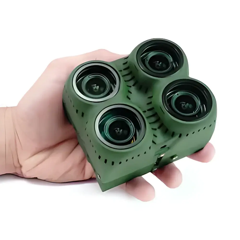
MapIR K4 Octo-Channel Multispectral Imaging System
| Brand | MapIR |
|---|---|
| Origin | USA |
| Manufacturer Type | Authorized Distributor |
| Import Status | Imported |
| Model | K4 Octo-Channel |
| Operating Principle | Filter-Wheel-Free Filter-Based Imaging |
| Imaging Method | Discrete Bandpass Filter Array |
| Deployment Platform | Airborne (UAV-Mounted) |
| Instantaneous Field of View (IFOV) | 2.0 cm/pixel at 120 m AGL (400 ft AGL), 14.4 MP resolution |
| Frame Rate | 2 fps (3.2 MP RAW), 1 fps (14.4 MP RAW) |
| Processor | Freescale i.MX6 Dual-Core ARM Cortex-A9 @ 1.2 GHz |
| Detectors | Two Sensor Types — Global Shutter Monochrome (13.2 MP, 3.45 µm pixel pitch) and Bayer RGB (14.4 MP, 1.4 µm pixel pitch) |
| Trigger Interface | PWM, Relay Pulse (High/Low), UAVCAN, UART |
| Image Format | 12-bit RAW per channel, 16-bit TIFF export |
| Lens Options | 87° or 41° Horizontal Field of View |
| Storage | Removable microSDXC (up to 128 GB) |
| Power | 5.0 VDC, 4.0 W per module |
| Connectivity | USB 2.0, UART, UAVCAN, I²C, Ethernet, GPIO, HDMI, SD Video, 40-pin Side Port, 60-pin Bottom Expansion Port |
Overview
The MapIR K4 Octo-Channel Multispectral Imaging System is a modular, airborne-optimized multispectral sensor platform engineered for high-fidelity spectral data acquisition in remote sensing applications. Unlike scanning or push-broom hyperspectral systems, the K4 employs a filter-based, snapshot acquisition architecture—leveraging discrete, narrowband interference filters mounted directly over individual monochrome or Bayer sensors. This design eliminates moving parts and mechanical filter wheels, ensuring mechanical robustness, timing synchronization across all eight channels, and immunity to motion-induced spectral misregistration during UAV flight. Each of the eight optical modules operates independently with its own Linux-based computing core, global-shutter imaging capability, and on-board storage, enabling parallel acquisition, real-time metadata embedding, and deterministic trigger response. The system is calibrated for radiometric consistency across channels and supports post-acquisition normalization using onboard dark-frame and flat-field references. Its architecture aligns with ASTM E2767–22 (Standard Practice for Multispectral Imaging of Vegetation) and ISO 18631-1:2016 (Remote Sensing—Data Quality Assessment), making it suitable for scientific-grade vegetation indices (e.g., NDVI, NDRE, PRI), soil moisture estimation, and precision agriculture validation studies.
Key Features
- Modular octo-channel design: Eight physically independent imaging modules, each with dedicated ARM Cortex-A9 processor, sensor, lens, and filter—enabling flexible reconfiguration without system-level recalibration.
- Two-tier sensor architecture: Combines high-resolution Bayer RGB (14.4 MP, 1.4 µm pixels) for spatial context with global-shutter monochrome sensors (13.2 MP, 3.45 µm pixels) for quantitative spectral band capture.
- Field-reconfigurable spectral bands: Users may select any two custom wavelengths from a library spanning 405 nm to 945 nm (e.g., 475/550/850 nm, 490/615/808 nm, or 395/870 nm), allowing tailored spectral response for specific biophysical parameters.
- Deterministic triggering: Hardware-level support for PWM, relay pulse (TTL-compatible), and UAVCAN-based synchronization ensures sub-millisecond latency between flight controller commands and image capture—critical for georeferenced mosaic stitching.
- Onboard data integrity: All images are stored as 12-bit RAW per channel with embedded EXIF and XMP metadata (GPS time stamp, IMU attitude, exposure settings, filter ID, temperature). Full audit trail is maintained via timestamped log files on removable microSDXC cards (up to 128 GB).
- Open hardware interface: Standardized 40-pin side port and 60-pin bottom expansion port provide access to I²C, UART, GPIO, Ethernet, and power rails—facilitating integration with third-party inertial navigation units (INS), RTK GNSS receivers, or custom telemetry systems.
Sample Compatibility & Compliance
The K4 is designed exclusively for airborne deployment on fixed-wing and multirotor UAV platforms compliant with FAA Part 107 and EASA UAS Regulation (EU) 2019/947. Its lightweight, low-power architecture (4.0 W/module, 5.0 VDC input) meets typical payload constraints for Class I and II unmanned aircraft. While not an in-situ contact instrument, the K4’s spectral response is traceable to NIST-calibrated reference lamps and validated against standardized reflectance panels (Labsphere Spectralon® 99% white, 2% black) per ISO 18631-2:2016 procedures. Data output conforms to GDAL-compliant GeoTIFF standards with embedded RPC (Rational Polynomial Coefficient) models, supporting interoperability with ENVI, QGIS, Agisoft Metashape, and Pix4Dmapper. For regulated environments—including USDA-certified crop monitoring programs or EPA-funded wetland mapping—the K4 supports optional GLP-aligned logging (timestamped sensor health diagnostics, thermal drift compensation records) and can be configured to meet FDA 21 CFR Part 11 requirements for electronic records when paired with validated workflow software.
Software & Data Management
MapIR provides the open-source K4 Capture Suite, a cross-platform (Linux/macOS/Windows) CLI and GUI application for firmware updates, spectral band definition, trigger configuration, and batch RAW-to-TIFF conversion with radiometric correction. All raw data is stored unprocessed on microSDXC cards in a hierarchical directory structure: /capture/YYYY-MM-DD/HH-MM-SS_K4_MODULEID/, with corresponding .json sidecar files containing full sensor calibration coefficients, GPS ephemeris, and IMU quaternion data. The system supports direct ingestion into Python-based processing pipelines via mapir-k4-sdk (PyPI package), which includes utilities for band math, atmospheric correction (DOS1 model), and index computation (e.g., MCARI, OSAVI). No proprietary cloud service is required; users retain full ownership and control of raw datasets. Firmware logs are archived in CSV format with millisecond-precision timestamps, enabling forensic analysis of acquisition anomalies during post-flight QA/QC audits.
Applications
- Precision agriculture: High-resolution canopy health assessment via NDVI (550/850 nm), chlorophyll content mapping (685/725 nm), and water stress detection (870/940 nm) across fields exceeding 1 km².
- Ecological monitoring: Species classification in mixed forest stands using visible-near-infrared (VNIR) spectral signatures; invasive plant detection through red-edge shift analysis.
- Environmental compliance: Post-wildfire burn severity mapping (dNBR derivation), mine reclamation progress tracking (NDVI temporal series), and coastal wetland vegetation zonation (using 475/550/660/850 nm combinations).
- Infrastructure inspection: Photovoltaic panel defect identification via thermal-reflective anomaly detection (808/870 nm), and solar farm performance benchmarking against historical spectral baselines.
- Academic research: Validation of radiative transfer models (e.g., PROSAIL, SAIL) using co-located ground truth spectra and synchronized K4 aerial acquisitions under controlled illumination conditions.
FAQ
Is the K4 compatible with DJI Matrice 300 RTK and Autel EVO Max 4T?
Yes—the K4 supports UAVCAN v1.0 and TTL-level PWM triggering, enabling native integration with DJI’s Payload SDK and Autel’s Open Protocol. Flight control synchronization requires a supported CAN bus adapter (e.g., CubePilot CUAV CanSat or Holybro Durandal).
Can I replace only one sensor module without recalibrating the entire system?
Yes—each module contains factory-stored calibration coefficients (gain, offset, non-uniformity correction LUTs). Replacing a single module retains inter-channel radiometric consistency if the replacement unit is from the same production lot and loaded with matching firmware.
Does the K4 support real-time video streaming?
No—it is optimized for still-frame capture with embedded metadata, not live video. HDMI output is provided solely for diagnostic preview and does not carry synchronized spectral channel overlays.
What spectral calibration documentation is provided with each unit?
Each K4 ships with a NIST-traceable spectral responsivity report (per channel), dark current vs. temperature curves, and flat-field uniformity maps measured at three illumination levels (10%, 50%, 90% saturation), compliant with ISO 15739:2013.
Is firmware open source?
The bootloader and low-level sensor drivers are closed-source for IP protection, but the user-facing Linux application layer (including capture logic and metadata generation) is published under MIT License on GitHub.