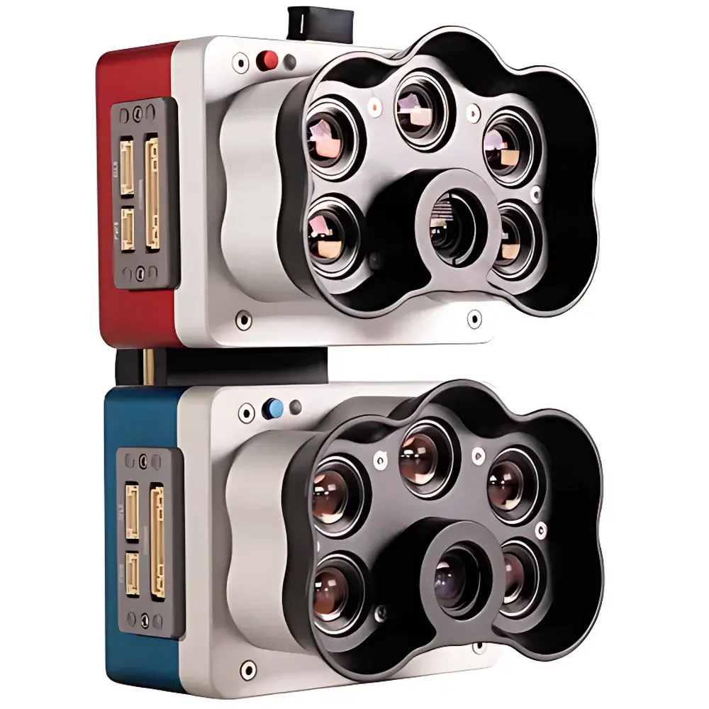
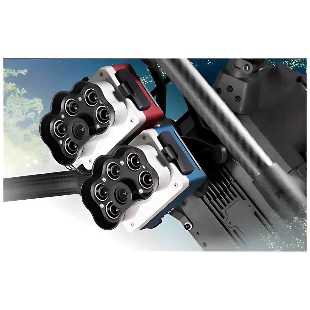
MicaSense RedEdge-P Dual 10-Band Hyperspectral Imaging Camera
| Brand | MicaSense |
|---|---|
| Origin | USA |
| Manufacturer Type | Authorized Distributor |
| Import Status | Imported |
| Model | RedEdge-P Dual |
| Pricing | Available Upon Request |
| Weight | 745 g |
| Power Input | 7.0–25.2 V DC |
| Sensor Resolution | 1456 × 1088 (Multispectral, 1.6 MP per band) & 2464 × 2056 (Panchromatic, 5.1 MP) |
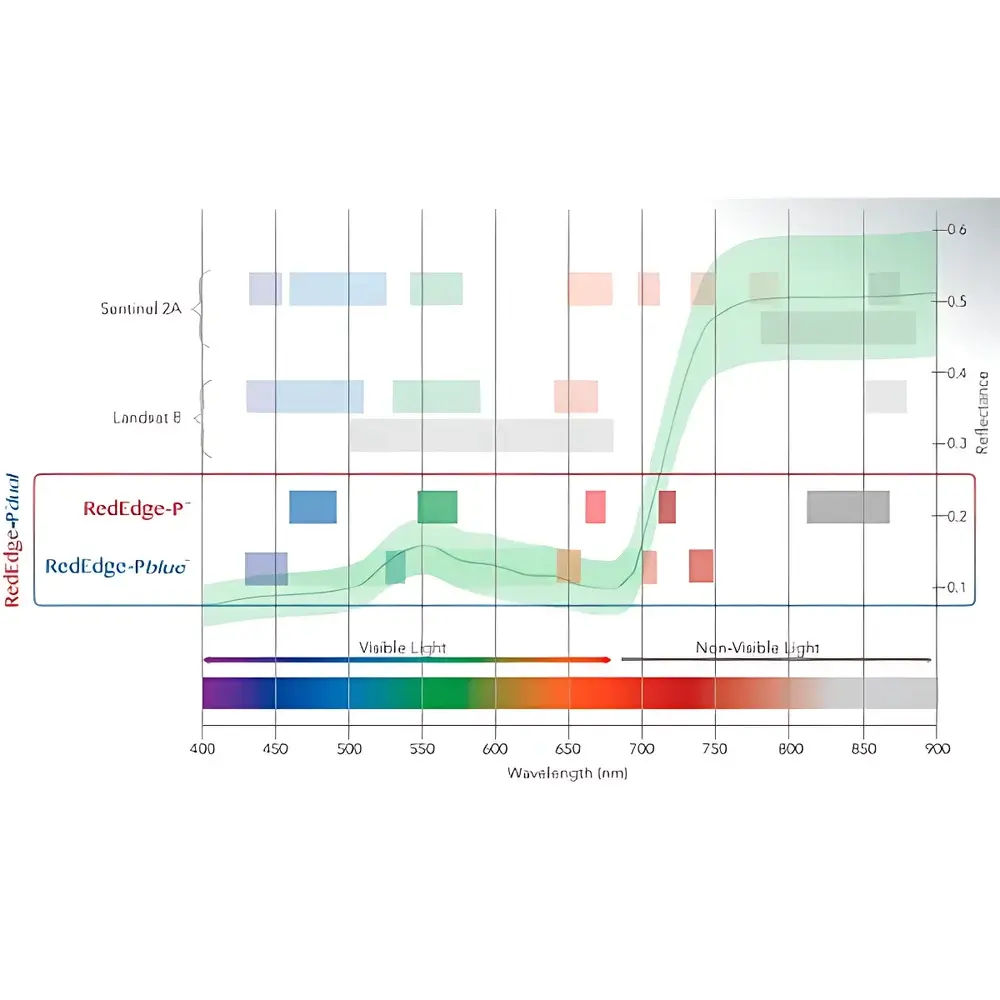
| Spectral Bands | Coastal Blue 444 nm (28 nm FWHM), Blue 475 nm (32 nm), Green 531 nm (14 nm), Green 560 nm (27 nm), Red 650 nm (16 nm), Red 668 nm (14 nm), Red Edge 705 nm (10 nm), Red Edge 717 nm (12 nm), NIR 740 nm (18 nm), NIR 842 nm (57 nm) |
| Capture Rate | Up to 3 frames/sec (raw DNG) |
| GSD | 2 cm/pixel at 60 m AGL |
| Calibration | Integrated Downwelling Light Sensor v2 (DLS2) + Calibrated Reflectance Panel (CRP) |
| Compatibility | DJI Matrice 300 RTK and other industrial UAV platforms |
| Data Processing | Compatible with Pix4Dmapper, Agisoft Metashape, ENVI, QGIS, and Python-based spectral analysis workflows |
Overview
The MicaSense RedEdge-P Dual is a high-precision, dual-sensor multispectral imaging system engineered for scientific-grade remote sensing applications in agriculture, forestry, coastal ecology, urban land-use mapping, and inland/water quality monitoring. Unlike conventional RGB or broad-band multispectral sensors, the RedEdge-P Dual implements a calibrated, narrowband spectral architecture based on ten discrete photodiode arrays—each equipped with interference-filtered CMOS sensors—to capture radiometrically accurate reflectance data across scientifically defined spectral windows. Its measurement principle relies on passive solar reflectance spectroscopy: incident sunlight is reflected from surface targets, collected through synchronized optical paths, and resolved into ten spectrally distinct bands using precision interference filters and temperature-stabilized sensor electronics. This enables robust derivation of vegetation indices (e.g., NDVI, NDRE, CIgreen, EVI, SAVI), water quality proxies (e.g., turbidity, chlorophyll-a, CDOM), and benthic habitat classification—particularly enhanced by its unique Coastal Blue (444 nm) band optimized for shallow-water penetration and macrophyte discrimination.
Key Features
- 10 independent narrowband spectral channels with full spectral calibration traceable to NIST-traceable standards, supporting repeatable inter-sensor and inter-campaign data comparison.
- Dual-camera architecture co-mounted on a rigid carbon-fiber frame, enabling simultaneous acquisition of two complementary spectral sets—including redundant coverage of critical red-edge and NIR regions for improved signal-to-noise ratio and atmospheric correction stability.
- Integrated Downwelling Light Sensor v2 (DLS2) providing real-time irradiance measurement at the sensor plane, enabling per-frame radiometric normalization under variable illumination conditions (e.g., cloud transit, diurnal variation).
- Panchromatic (5.1 MP) channel fused with multispectral data to deliver 2 cm ground sampling distance (GSD) at 60 m above ground level—enabling detection of sub-canopy stress indicators, individual weed clusters, and fine-scale coastal sediment patterns.
- Onboard raw DNG capture with lossless 12-bit quantization, preserving full dynamic range for post-processing radiometric calibration, atmospheric correction (e.g., DOS, QUAC, FLAASH), and spectral unmixing.
- Industrial-grade mechanical and thermal design compliant with IP54 environmental rating; operational temperature range: −10 °C to 50 °C; shock and vibration tested per MIL-STD-810G for UAV deployment.
Sample Compatibility & Compliance
The RedEdge-P Dual is designed for non-contact, non-destructive surface reflectance measurement of natural and managed surfaces—including vegetated canopies, soil substrates, aquatic surfaces, built environments, and geological outcrops. It requires no sample preparation and operates under ambient solar illumination. The system adheres to ASTM E2593-22 (Standard Practice for Remote Sensing of Vegetation Health), ISO 19130-2:2021 (Geographic information — Imagery sensor models), and supports GLP-compliant field data collection when used with documented calibration protocols (CRP + DLS2). Radiometric outputs are compatible with FDA 21 CFR Part 11–aligned metadata logging when integrated into validated drone survey workflows using certified software platforms (e.g., Pix4Dfields with audit trail configuration).
Software & Data Management
Data acquisition is supported via MicaSense’s open SDK and QGroundControl integration, enabling automated mission scripting and real-time telemetry sync. Raw DNG files embed EXIF metadata including GPS position, IMU orientation, DLS2 irradiance values, and sensor temperature—ensuring traceability for reproducible processing. Standard photogrammetric pipelines (Pix4Dmapper, Agisoft Metashape) generate orthomosaics and point clouds with embedded reflectance maps. Advanced spectral analysis is enabled via ENVI, Python (scikit-learn, spectral, rasterio), and R (hyperSpec, rastervis), with native support for common index libraries and custom spectral signature modeling. All calibration artifacts—including CRP reference images and DLS2 logs—are archived alongside raw data to satisfy ISO/IEC 17025 documentation requirements for laboratory-grade remote sensing validation.
Applications
- Agriculture: High-resolution crop health monitoring, nitrogen use efficiency mapping, early disease detection (e.g., Fusarium head blight), and yield prediction via time-series NDVI/NDRE trajectories.
- Forestry: Species classification, canopy density estimation, post-fire regeneration assessment, and invasive species detection using red-edge and NIR spectral divergence.
- Coastal & Aquatic Monitoring: Seagrass and kelp bed delineation, bathymetric inversion in optically shallow waters (< 5 m depth), and suspended sediment load estimation leveraging the 444 nm Coastal Blue band.
- Urban Planning: Impervious surface mapping, green infrastructure performance evaluation, and thermal proxy derivation via normalized vegetation–impervious–soil (NVis) indices.
- Environmental Compliance: Long-term ecological trend analysis aligned with Landsat 8 and Sentinel-2 time series, supporting EPA Tier 3 monitoring protocols and EU INSPIRE data interoperability standards.
FAQ
Is the RedEdge-P Dual compatible with DJI M300 RTK firmware v4.0+?
Yes—the camera integrates natively via SDK and supports dual-gimbal mounting configurations with synchronized trigger and telemetry handshake.
Does it support radiometric calibration without external hardware?
No—radiometric accuracy requires concurrent use of the included Calibrated Reflectance Panel (CRP) and DLS2 sensor; both are essential for absolute reflectance conversion.
Can raw DNG files be processed offline without cloud services?
Yes—all processing is fully local and open-format; no proprietary cloud dependency or license activation is required.
What spectral indices are pre-configured in Pix4Dfields for RedEdge-P Dual data?
Pix4Dfields includes NDVI, NDRE, CIgreen, SAVI, EVI, and custom index templates aligned with USDA-NRCS and FAO crop monitoring guidelines.
Is the Coastal Blue band suitable for deep-water applications?
No—it is specifically optimized for <5 m depth in clear coastal and estuarine waters; deeper applications require active LiDAR or hyperspectral systems with extended blue-green transmission.