ENVIdata-EV Snow and Ice Evaporation Measurement System
| Brand | AZ (Beijing AoZuo) |
|---|---|
| Origin | Beijing, China |
| Manufacturer | Yes |
| Country of Origin | China |
| Model | ENVIdata-EV |
| Instrument Type | Specialized Weather Station for Cryospheric Evaporation Monitoring |
| Price Range | USD 14,000 – 42,000 (approx.) |
| Evaporation Pan Diameters | 50 cm / 80 cm / 100 cm (selectable) |
| Pan Height | 30 cm |
| Max Load Capacity | 100 kg |
| Operating Temperature | −30 °C to +50 °C (pan unit) |
| Scan Rate | Up to 25 Hz |
| A/D Converter | 18-bit, Accuracy ±0.025% |
| Internal Memory | 128 MB (stores up to 130,000 readings) |
| Display | 2-line × 16-character LCD with 6-button interface |
| Communication Interfaces | RS-232, USB, Ethernet |
| Sampling Interval | Configurable from 10 ms to 24 h |
Overview
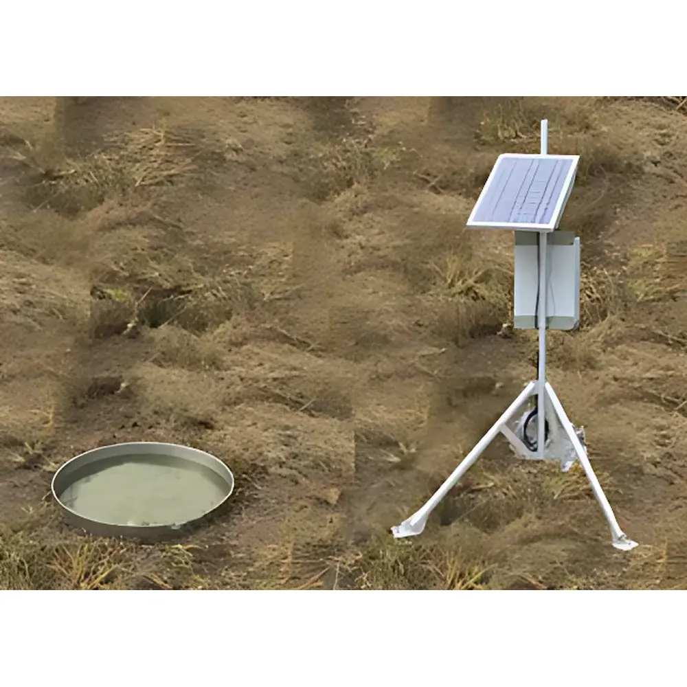
The ENVIdata-EV Snow and Ice Evaporation Measurement System is a field-deployable, high-stability weighing lysimeter designed specifically for direct, continuous quantification of evaporation flux from snowpacks and ice surfaces in cold-region hydrological and climatological research. Unlike conventional pan-based evaporation estimators that rely on empirical correction factors or energy-balance modeling, the ENVIdata-EV implements precision mass-loss measurement grounded in gravimetric principles—tracking minute changes in total system mass over time to derive evaporation depth (mm) with traceable resolution of 0.01 mm. This approach eliminates assumptions related to aerodynamic resistance, surface temperature gradients, or latent heat partitioning, making it especially suitable for validation of remote-sensing evapotranspiration products, calibration of land-surface models in alpine and polar environments, and long-term cryosphere–climate interaction studies.
Key Features
- Triple-diameter evaporimeter options (50 cm, 80 cm, 100 cm) allow scaling to site-specific snow accumulation depth, wind exposure, and spatial representativeness requirements while maintaining consistent edge-to-area ratio design.
- Integrated high-resolution load cell system calibrated to deliver mass change detection equivalent to ≤0.01 mm water-depth evaporation under ambient thermal drift compensation protocols.
- Ruggedized data acquisition unit rated for extreme cold (−45 °C) and high-temperature operation (up to +70 °C), featuring an 18-bit analog-to-digital converter with ±0.025% full-scale accuracy and programmable scan rates up to 25 Hz for transient event capture (e.g., diurnal melt–refreeze cycles).
- Multi-interface connectivity (RS-232, USB 2.0, 10/100 Mbps Ethernet) enables flexible integration into existing telemetry infrastructure—including satellite, cellular, or LoRaWAN gateways—without requiring onsite manual retrieval.
- Onboard 128 MB non-volatile memory supports autonomous logging of >130,000 timestamped mass readings; expandable via industrial-grade SD/CF cards or direct USB mass storage export.
- Local human–machine interface includes a dual-line LCD display and six tactile buttons for real-time channel inspection, battery status verification, firmware diagnostics, and manual trigger execution—critical for unattended winter deployments.
Sample Compatibility & Compliance
The ENVIdata-EV is engineered for direct deployment on natural snowfields, glacial firn, lake ice, and artificial ice surfaces under open-sky or sheltered conditions. Its stainless-steel pan construction and low-thermal-mass load cell assembly minimize radiative heating artifacts and ensure mechanical stability across freeze–thaw cycles. The system complies with core metrological practices outlined in ISO 9060:2018 (spectral responsivity classification for solar radiation instruments) and aligns with WMO No. 8 guidelines for evaporation observation standards. While not certified to IEC 61326-1 (EMC) or UL 61010-1 (safety) out-of-the-box, its modular architecture permits third-party certification for specific national regulatory frameworks upon request. Data provenance meets GLP-aligned metadata tagging (timestamp, sensor ID, calibration epoch, environmental context flags) required for peer-reviewed hydrological datasets.
Software & Data Management
Data collected by the ENVIdata-EV are transmitted via TCP/IP or HTTP(S) protocols to the ENVIdata Cloud Platform—a secure, ISO/IEC 27001-aligned server environment hosted either on customer-managed infrastructure or within AoZuo’s Tier-III-certified data center. The platform provides RESTful API access, role-based user permissions, automated QC flagging (e.g., outlier detection based on physical plausibility thresholds), and time-series interpolation tools compliant with CF-1.8 netCDF conventions. All raw and processed datasets include embedded audit trails satisfying FDA 21 CFR Part 11 requirements for electronic records and signatures when deployed in regulated environmental monitoring programs. Local software clients support batch download, spectral analysis (FFT), cumulative mass-loss curve generation, and export to MATLAB, Python (Pandas/NetCDF4), and GIS-ready formats (GeoTIFF, CSV with WKT geometry).
Applications
- Quantifying sublimation losses from seasonal snowpacks in mountainous watersheds to improve snowmelt-runoff forecasting accuracy.
- Validating eddy-covariance and scintillometer-derived turbulent flux estimates in high-albedo, low-wind-speed regimes where energy-balance closure remains problematic.
- Long-term monitoring of ablation dynamics on debris-covered glaciers and ice caps under climate change scenarios.
- Calibrating microwave and optical satellite sensors (e.g., MODIS, Sentinel-3 SLSTR) for snow water equivalent (SWE) and surface energy balance retrievals.
- Supporting IPCC AR6 Chapter 2 (Changing State of the Climate System) observational benchmarks for cryospheric evaporation trends.
- Field validation of regional climate model (RCM) parameterizations of snow–atmosphere coupling in CMIP6 experiments.
FAQ
What meteorological parameters does the ENVIdata-EV measure directly?
It measures mass loss (g) of the snow/ice–pan system at user-defined intervals; all derived variables—including evaporation depth (mm), cumulative evaporation (mm), and instantaneous evaporation rate (mm/h)—are computed onboard or in post-processing using pan geometry and density assumptions.
Can the system operate autonomously for extended periods without maintenance?
Yes. With external power (e.g., solar panel + deep-cycle battery), the system supports continuous operation for ≥12 months in temperate zones and ≥6 months in high-latitude winter conditions, assuming standard 1-minute sampling and daily data transmission.
Is frost heave or ice adhesion compensated for in the weighing mechanism?
The load cell mounting design incorporates lateral constraint damping and thermal expansion compensation; however, users must install the pan on a stable, frost-free foundation (e.g., driven steel piling or gravel pad) to mitigate mechanical coupling artifacts.
Does the system support integration with third-party weather stations?
Yes. The data logger accepts analog/digital inputs from co-located sensors (e.g., net radiometers, sonic anemometers, soil heat flux plates) and synchronizes timestamps to GPS or NTP sources for multi-instrument flux synthesis.
How is calibration traceability maintained over multi-year deployments?
Each unit ships with NIST-traceable calibration certificates for the load cell and temperature-compensated reference resistor network; field recalibration kits and documented procedures are available for annual verification per ISO/IEC 17025 laboratory practice guidelines.
Related Products


