4H-JENA PocketFerrybox Portable Aquatic Ecosystem Monitoring System
| Brand | 4H-JENA |
|---|---|
| Origin | Germany |
| Model | PocketFerrybox |
| Power Supply | High-capacity rechargeable battery pack |
| Deployment Mode | Vessel-mounted (ferrybox), field-deployable station, or small-boat integration |
| Sensor Integration | Modular, multi-vendor, plug-and-play interface |
| Communication | Ethernet, RS-485, 4G/LTE, optional satellite uplink |
| GPS | Integrated high-precision GNSS receiver (GPS/GLONASS/Galileo) |
| Compliance | CE, RoHS, IP67 enclosure rating |
| Operating Temperature | −10 °C to +45 °C |
| Data Storage | Internal SSD (≥128 GB) + redundant SD card slot |
| Software Platform | FerryControl v4.2 (Windows/Linux-compatible, touch-optimized UI) |
| Regulatory Alignment | Supports ASTM D8083 (in-situ water quality monitoring), ISO 5667-22 (field measurement protocols), and GLP-compliant audit trail logging per FDA 21 CFR Part 11 requirements |
Overview
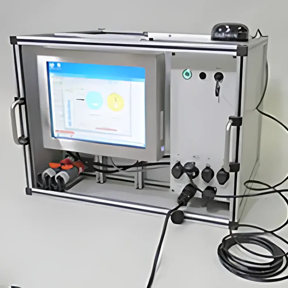
The 4H-JENA PocketFerrybox is a compact, self-contained aquatic ecosystem monitoring platform engineered for high-fidelity, real-time, multi-parameter water quality assessment in dynamic marine, estuarine, and freshwater environments. Unlike fixed buoy-based or laboratory-dependent systems, the PocketFerrybox implements a true ferrybox architecture—leveraging continuous flow-through sampling combined with synchronized optical, electrochemical, and fluorometric sensor arrays to deliver spatially resolved, time-stamped environmental profiles. Its core design principle centers on metrological traceability: each integrated sensor undergoes factory calibration against NIST-traceable standards, and in-field verification is supported via automated zero/span checks and reference solution injection routines. The system operates autonomously for up to 30 days on a single battery charge (depending on sensor load and telemetry frequency), making it suitable for long-term deployments on research vessels, autonomous surface vehicles (ASVs), or temporary shore-based stations where grid power is unavailable.
Key Features
- Modular sensor architecture supporting simultaneous acquisition of ≥25 physicochemical and biological parameters without cross-interference
- Integrated GNSS module enabling georeferenced data mapping with sub-meter positional accuracy and automatic trajectory interpolation
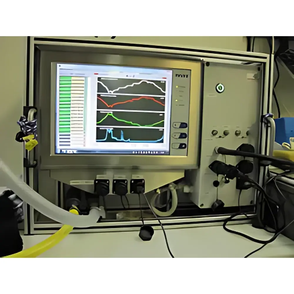
- Touch-enabled control interface with intuitive workflow navigation, real-time sensor status dashboard, and context-aware alarm prioritization
- Onboard data processing engine performing real-time unit conversion, temperature compensation, and baseline drift correction per sensor type
- Remote configuration and firmware updates via secure HTTPS/SSH channels; configurable alert thresholds with SMS/email/push notifications
- Ruggedized aluminum housing rated IP67, corrosion-resistant wetted materials (titanium, PEEK, Viton), and pressure-compensated optical cells for depths up to 10 m
- Pre-certified compatibility with third-party sensors adhering to SDI-12, Modbus RTU, or analog 4–20 mA protocols
Sample Compatibility & Compliance
The PocketFerrybox is validated for use across saline gradients (0–40 PSU), turbidities up to 750 FTU, and organic loading conditions typical of eutrophic lakes, coastal runoff zones, and wastewater-impacted estuaries. All electrochemical probes (pH, ORP, DO) feature double-junction reference electrodes and anti-fouling membranes to ensure stability during extended immersion. Optical sensors utilize dual-wavelength excitation and spectral deconvolution algorithms to resolve overlapping fluorophores (e.g., phycocyanin vs. phycoerythrin) and correct for inner-filter effects caused by CDOM absorption. The system meets ISO 17025-accredited calibration intervals for routine operation and supports full audit trails—including operator login events, parameter modifications, calibration logs, and data export history—as required under GLP and GMP frameworks. It also complies with EU Water Framework Directive (WFD) Annex V reporting formats and integrates seamlessly with national monitoring databases via standardized XML/CSV export templates.
Software & Data Management
FerryControl software provides a unified environment for mission planning, live telemetry visualization, post-processing, and regulatory reporting. Users define monitoring programs based on temporal triggers (e.g., every 30 seconds), spatial intervals (e.g., per 10 m GPS distance), or event-driven logic (e.g., DO drop >10% from baseline). Raw sensor outputs are stored in HDF5 format with embedded metadata (UTC timestamps, GPS coordinates, sensor serial numbers, calibration coefficients). Trend analysis tools include moving-average smoothing, seasonal decomposition, anomaly detection using Hampel filtering, and correlation matrices across parameter sets. Export options include netCDF4 (CF-1.8 compliant), Excel-compatible CSV, and direct ingestion into PostgreSQL or InfluxDB time-series databases. Audit logs record all user actions with cryptographic hashing to satisfy FDA 21 CFR Part 11 electronic signature requirements.
Applications
- Coastal hypoxia mapping and early warning of harmful algal bloom (HAB) initiation using chlorophyll-a, phycocyanin, and CDOM co-variation
- Riverine nutrient flux quantification (NO₃⁻, PO₄³⁻, NH₄⁺, SiO₄⁴⁻) during stormwater events and baseflow periods
- Marine oil spill detection and dispersion modeling via crude oil fluorescence (PTSA) and rhodamine WT tracers
- Reservoir stratification profiling through vertical towed deployments coupled with real-time density calculation (σₜ)
- Ecological baseline studies for offshore wind farm impact assessments, including benthic-pelagic coupling indicators
- Validation of satellite-derived ocean color products (e.g., Sentinel-3 OLCI, Landsat 9 OLI-2) using in-situ match-up datasets
FAQ
What deployment configurations does the PocketFerrybox support?
It operates in three primary modes: (1) vessel-integrated ferrybox (flow-through seawater intake), (2) static mooring with pumped intake and anti-fouling bypass loop, and (3) portable backpack configuration for rapid-response riverbank surveys.
Can the system operate unattended for extended periods?
Yes—configured with low-power sensors and 15-minute telemetry intervals, battery life exceeds 25 days. Optional solar charging kits extend operational duration indefinitely in sun-exposed deployments.
How is sensor calibration maintained during long-term missions?
The system supports automated in-situ calibration using programmable peristaltic dosing of certified standard solutions (e.g., Winkler titrant for DO, NBS buffers for pH), logged with full traceability to CRM certificates.
Is raw data accessible for custom algorithm development?
All sensor-level digital outputs (including dark current, gain settings, and raw ADC counts) are exposed via API endpoints and included in HDF5 archives, enabling reproducible reprocessing and machine learning model training.
Does the PocketFerrybox meet regulatory requirements for environmental reporting?
Yes—it generates audit-ready reports aligned with EPA Method 1600 series, ISO 5667-22 field validation criteria, and EU INSPIRE metadata standards, including uncertainty budgets per parameter per measurement cycle.


