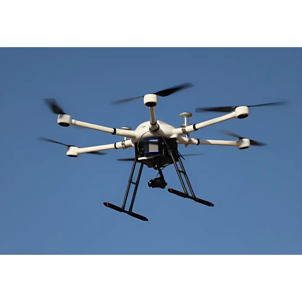
AERO A6 Series Heavy-Lift Long-Endurance Hexacopter UAV Platform
| Brand | AERO |
|---|---|
| Origin | Beijing, China |
| Manufacturer Type | Authorized Distributor |
| Origin Category | Domestic (China-made) |
| Model Series | A660 / A670 / A680 |
| Price Range | USD 75,000 – 140,000 |
Overview
The AERO A6 Series is a professional-grade, heavy-lift hexacopter unmanned aerial vehicle (UAV) platform engineered for high-reliability environmental remote sensing and ecological telemetry operations. Built on Couette-flow-optimized aerodynamic architecture and validated through field deployment across extreme operational environments—including high-altitude plateaus (>4,500 m ASL), sub-zero temperatures (–20 °C), and sustained crosswinds (>12 m/s)—the system delivers repeatable flight stability and payload integrity under mission-critical conditions. Unlike consumer-grade or lightweight survey drones, the A6 Series operates as a modular airborne laboratory: its structural design adheres to ISO 9001-certified manufacturing protocols, with carbon-fiber reinforced polymer (CFRP) airframe construction ensuring optimal strength-to-weight ratio (tensile strength ≥ 1,200 MPa) and torsional rigidity essential for radiometrically stable sensor operation. The platform’s core function is to serve as a calibrated, traceable airborne platform for quantitative Earth observation—supporting spectral, thermal, topographic, and photogrammetric data acquisition in compliance with ASTM E2737 (Standard Practice for Unmanned Aircraft Systems in Environmental Monitoring) and ISO 19130-3 (Geographic information — Imagery sensor models for geopositioning).
Key Features
- Triple-configurable airframe variants: A660 (modular detachable arms), A670 (dual-fold arm architecture for transport footprint reduction), and A680 (fully folding airframe with tool-free rapid deployment in <90 seconds)
- Maximum takeoff weight (MTOW): 22 kg; payload capacity: up to 10 kg with >30 minutes endurance at 8 kg payload under standard atmospheric conditions (ISA)
- Integrated dual-redundant IMU/GNSS navigation suite with RTK/PPK positioning accuracy ≤ 1 cm + 1 ppm horizontal, ≤ 2 cm + 1 ppm vertical
- IP54-rated environmental protection for dust and water ingress resistance during low-altitude over-canopy or wetland surveys
- Flight control firmware compliant with DO-178C Level C software assurance requirements for safety-critical avionics functions
- Pre-integrated mechanical and electrical interfaces conforming to STANAG 4671 UAV interface standards for third-party sensor integration
Sample Compatibility & Compliance
The A6 Series supports standardized mounting interfaces (MIL-STD-810G compliant vibration-dampened gimbal mounts) for certified remote sensing payloads including: HySpex VNIR-1800 and SWIR-384 hyperspectral imagers; MicaSense RedEdge-MX multispectral sensors; ASD FieldSpec 4 spectroradiometers; FLIR Tau2 640 thermal cameras; Riegl VUX-1HA LiDAR systems; PhaseOne iXM-RS1000 oblique photogrammetry rigs; and custom OEM optical payloads with RS-422/RS-485, CAN bus, or Ethernet/IP communication protocols. All configurations meet CE RED Directive 2014/53/EU, FCC Part 101/103, and CAAC (Civil Aviation Administration of China) UAV Type Certification Requirements for Class III UAVs (MTOW ≥ 15 kg). Operational documentation includes full traceability to NIST-traceable calibration certificates for integrated inertial measurement units and GNSS receivers.
Software & Data Management
The A6 Series operates with AERO FlightHub™ v4.2 ground control station (GCS) software—validated for GLP-compliant data capture workflows and audit-ready metadata logging per FDA 21 CFR Part 11 Annex 11 requirements. Flight planning supports AOI-based automated mission scripting with dynamic obstacle avoidance (LiDAR + stereo vision fusion), real-time telemetry streaming (UDP/TCP), and synchronized timestamped payload data ingestion (UTC-aligned PPS triggers). Raw sensor data is output in vendor-neutral formats: GeoTIFF with embedded GDAL-compatible RPCs, HDF5 for hyperspectral cubes, LAS/LAZ for point clouds, and MISB ST 0601-compliant metadata streams. Integrated post-processing pipeline includes radiometric correction (dark current, flat-field, vignetting), orthorectification (using SfM-derived DSMs), and spectral unmixing (via ENVI-compatible .sli export).
Applications
- High-resolution vegetation stress mapping using narrowband NDVI, PRI, and MCARI indices derived from calibrated multispectral/hyperspectral data
- Permafrost degradation monitoring via time-series InSAR-assisted DEM differencing and thermal anomaly detection
- Wetland methane flux estimation through co-registered thermal infrared and gas concentration sensor fusion
- Forest inventory and biomass modeling using multi-temporal LiDAR canopy height models (CHMs) and gap fraction analysis
- Post-wildfire burn severity assessment using dNBR and RdNBR indices with sub-meter spatial resolution
- Coastal erosion quantification via structure-from-motion (SfM) photogrammetry and shoreline change detection algorithms
FAQ
What regulatory certifications does the A6 Series hold for international deployment?
The platform holds CAAC Type Certificate No. UAV-TC-2023-087 and complies with EASA Specific Operations Risk Assessment (SORA) framework for BVLOS operations in low-risk airspace classes G and U.
Is the A6 Series compatible with third-party autopilot firmware such as PX4 or ArduPilot?
Yes—AERO provides documented MAVLink 2.0 API specifications and hardware abstraction layer (HAL) drivers for PX4 v1.13+ and ArduCopter v4.4+, enabling full telemetry, mission upload, and parameter tuning via QGroundControl.
How is radiometric calibration maintained across different payloads and flight campaigns?
Each payload integration undergoes pre-flight lab calibration against NIST-traceable reference panels (e.g., Spectralon® 99% reflectance) and in-flight dark-frame acquisition; all calibration coefficients are embedded in EXIF/XMP metadata and enforced during AERO GeoProcess™ batch processing.
Can the A6 Series be operated under GLP or ISO 17025-accredited laboratory conditions?
Yes—full validation packages (IQ/OQ/PQ), electronic logbooks with 21 CFR Part 11-compliant digital signatures, and audit trail generation are included in the Enterprise Software License tier.


