AERO Aero1000 Airborne & Ground-Coupled Ground Penetrating Radar System
| Brand | AERO |
|---|---|
| Origin | Beijing, China |
| Manufacturer Type | Authorized Distributor |
| Origin Category | Domestic (China) |
| Model | Aero1000 |
| Price | USD 79,500 (FOB Beijing) |
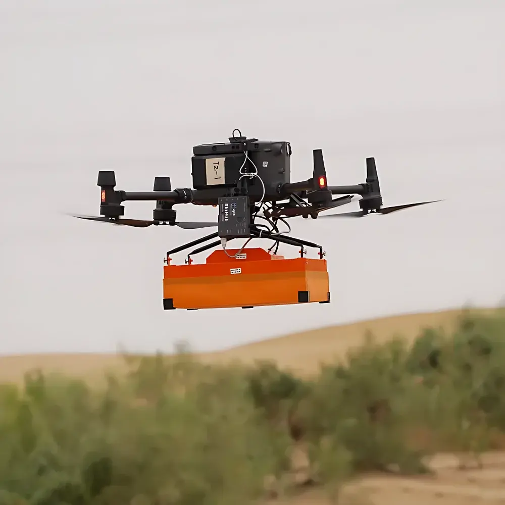
| Dimensions & Weight | Airborne Configuration: 31 × 19 × 15 cm, 1.7 kg |
| Ground Configuration | 52 × 43 × 21 cm, 7.0 kg |
| Operating Temperature | −20 °C to +60 °C |
| Dynamic Range | 0–84 dB |
| Sampling Rate | 25,600 samples/s |
| Depth Penetration | Up to 2 m (soil-dependent) |
| ADC Resolution | 16-bit |
| Trace Sampling Density | 512 samples/trace |
| Real-Time Terrain Following Capability | Yes (with integrated altimeter, 2 cm vertical accuracy at 1 m AGL) |
Overview
The AERO Aero1000 is a dual-mode, high-mobility Ground Penetrating Radar (GPR) system engineered for both airborne and ground-coupled operation. It operates on the principle of ultra-wideband electromagnetic pulse transmission and time-domain reflection analysis—emitting short-duration radar pulses (typically in the 100 MHz–2.5 GHz range, configurable via antenna selection) into subsurface media and recording amplitude- and time-resolved echoes from dielectric contrasts. Its modular architecture supports rapid reconfiguration between drone-mounted, handheld, vehicle-towed, and boat-deployed configurations, enabling consistent data acquisition across heterogeneous terrain without hardware replacement. Designed specifically for integration with DJI Matrice 300 RTK and A6-series UAV platforms, the Aero1000 maintains full synchronization with GNSS-INS navigation systems and supports real-time kinematic (RTK) positioning inputs for georeferenced radargram generation. The system’s lightweight airframe (1.7 kg) and low-power consumption (<12 W nominal) ensure extended flight endurance while preserving signal fidelity and spatial sampling density.
Key Features
- Modular deployment architecture: seamless transition between airborne, ground-pushed, vehicle-mounted, and marine towed modes
- Integrated terrain-following module with barometric altimeter and ultrasonic height sensor—enables stable 1 m AGL flight with ≤2 cm vertical accuracy for consistent near-surface resolution
- Configurable antenna interface supporting multiple center frequencies (e.g., 250 MHz for deep soil profiling, 900 MHz for utility detection, 2.3 GHz for shallow pavement or ice layer analysis)
- High-fidelity digitization: 16-bit analog-to-digital conversion with 25,600 samples per second and 512 samples per trace ensures high dynamic range (0–84 dB) and signal-to-noise ratio
- Ruggedized enclosure rated IP65 for dust and water resistance; operational in ambient temperatures from −20 °C to +60 °C
- Onboard storage (64 GB internal SSD) with optional external USB 3.0 interface for real-time data streaming and backup
Sample Compatibility & Compliance
The Aero1000 is compatible with a broad spectrum of subsurface materials—including dry sand, loam, glacial till, freshwater ice, snowpack, asphalt, concrete, and saturated clays—subject to electromagnetic attenuation characteristics. Antenna selection determines effective penetration depth and lateral resolution, with typical maximum depths ranging from 0.3 m (high-frequency antennas in conductive soils) to 2.0 m (low-frequency antennas in resistive, dry conditions). The system complies with IEC 61000-6-3 (EMC emission standards) and meets CE marking requirements for portable RF equipment. Data acquisition workflows support audit-ready metadata tagging (time, position, altitude, antenna ID, gain settings), facilitating alignment with ISO 2859-1 sampling plans and ASTM D6432-19 (Standard Guide for Using the Ground Penetrating Radar Method for Subsurface Investigations).
Software & Data Management
The Aero1000 ships with AERO GPR Studio v4.x—a cross-platform desktop application for post-processing, visualization, and interpretation. It supports standard file formats including SEG-Y, LAS, and CSV for interoperability with GIS (ArcGIS, QGIS), CAD (AutoCAD Civil 3D), and geophysical modeling tools (ReflexW, GPRSlice). Key software capabilities include topographic correction using DEM overlays, migration algorithms (Kirchhoff, f-k), background removal, gain balancing, and hyperbola fitting for target localization. All processing steps are logged with timestamps and user identifiers, satisfying traceability requirements under GLP and ISO/IEC 17025 laboratory accreditation frameworks. Optional add-ons include FDA 21 CFR Part 11-compliant electronic signature modules and encrypted cloud synchronization via secure TLS 1.3 endpoints.
Applications
- Geological mapping: bedrock interface identification, fracture zone delineation, and sediment thickness estimation
- Glaciology and snow hydrology: snow water equivalent (SWE) profiling, ice thickness measurement, and crevasse detection
- Cultural heritage preservation: non-invasive subsurface surveying of buried foundations, walls, and artifact concentrations in archaeological sites
- Civil infrastructure assessment: void detection beneath roadways and railway embankments, rebar/conduit mapping in concrete structures
- Environmental site characterization: landfill boundary definition, contaminant plume tracking, and UXO (unexploded ordnance) screening
- Disaster response: rapid assessment of landslide slip surfaces, sinkhole development, and flood-induced subsurface erosion
- Military and security operations: concealed tunnel detection, border surveillance, and forensic evidence recovery
FAQ
What UAV platforms are certified for Aero1000 integration?
The Aero1000 is validated for use with DJI Matrice 300 RTK and AERO A6-series drones. Integration includes CAN bus communication for power management, vibration isolation mounting, and synchronized trigger output with GNSS PPS signals.
Does the system support real-time data preview during flight?
Yes—via integrated Wi-Fi telemetry link, raw radargrams and GPS-annotated navigation data stream to the ground control station with <500 ms latency, enabling immediate quality assessment and adaptive mission adjustment.
Can the Aero1000 be used for underwater sediment profiling?
Not directly submerged; however, it supports boat-towed operation above water surface for shallow-water bathymetry and subaqueous sediment layer imaging where water column is ≤2 m and bottom reflectivity is sufficient.
Is firmware update capability available over-the-air (OTA)?
Firmware updates require local connection via USB-C; no OTA functionality is implemented to maintain deterministic timing behavior and regulatory compliance for field-deployed instrumentation.
What level of training and technical documentation is provided?
AERO delivers comprehensive operator certification training (2-day onsite or virtual), bilingual (English/Chinese) technical manuals, ASTM/ISO-aligned SOP templates, and lifetime access to version-controlled software releases and application notes.