AERO Aero500 Airborne & Ground-Coupled Ground Penetrating Radar System
| Brand | AERO |
|---|---|
| Origin | Beijing, China |
| Manufacturer Type | Authorized Distributor |
| Origin Category | Domestic (China) |
| Model | Aero500 |
| Price | USD 76,500 (FOB Beijing) |
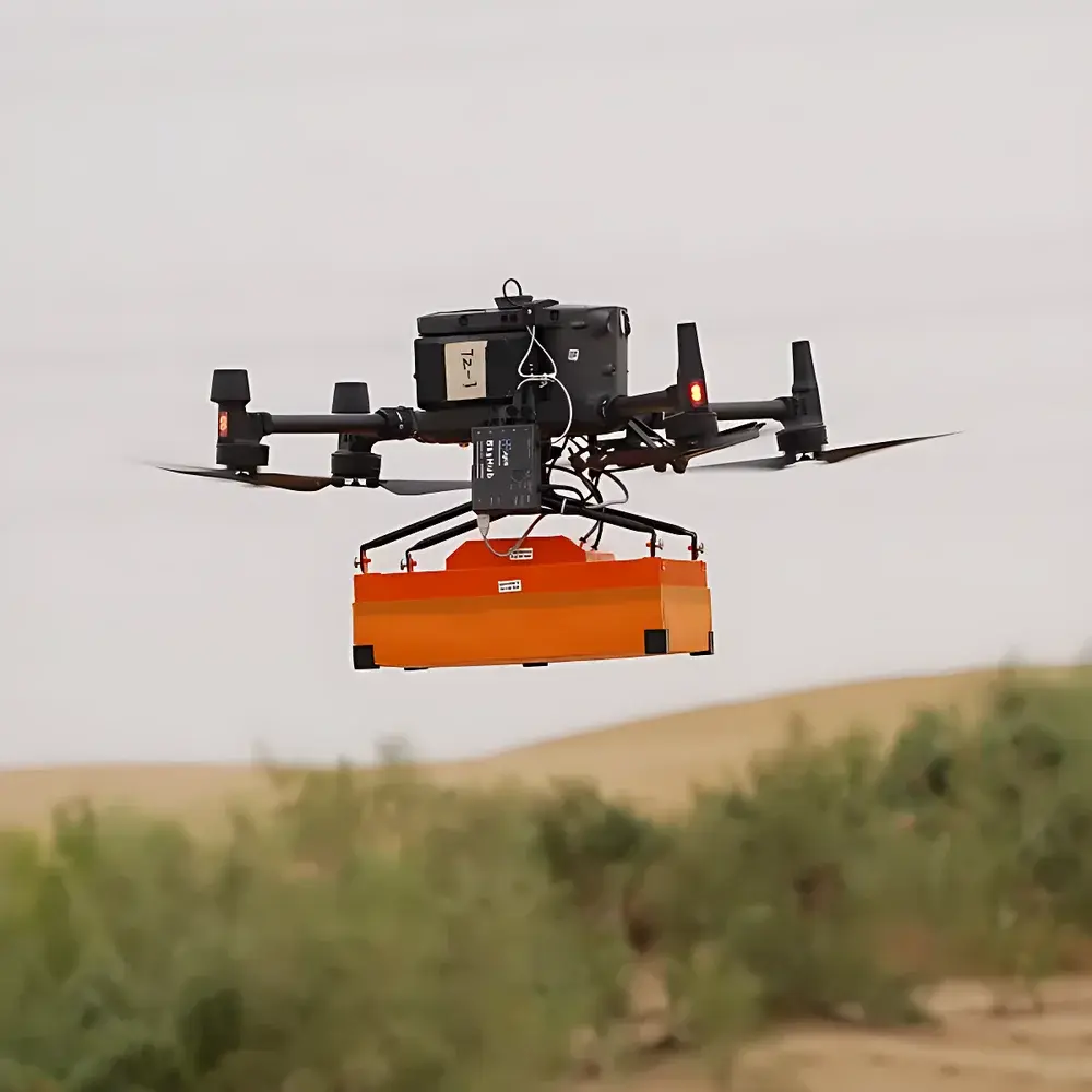
| Dimensions & Weight | Airborne Configuration — 41 × 31 × 16 cm, 2.1 kg |
| Operating Temperature | −20 °C to +60 °C |
| Dynamic Range | 0–84 dB |
| Sampling Rate | 25,600 samples/s |
| Depth Range (Typical) | 4 m @ 100 ns (in homogeneous low-conductivity media, e.g., dry sand or ice) |
| ADC Resolution | 16-bit |
| Trace Density | 512 samples/trace |
| Real-Time Terrain Following Capability | Yes (with integrated altimeter and AGS-2 cm vertical accuracy at 1 m AGL) |
Overview
The AERO Aero500 is a dual-mode, high-mobility Ground Penetrating Radar (GPR) system engineered for both airborne deployment on UAV platforms—including DJI Matrice 300 RTK and AERO A6-series drones—and versatile ground-based operation (handheld, cart-mounted, vehicle-towed, or marine-deployed). Its core architecture leverages ultra-wideband (UWB) pulse radar technology operating in the 100–900 MHz frequency band (configurable via interchangeable antenna modules), enabling time-domain electromagnetic wave propagation analysis to resolve subsurface dielectric contrasts. The system transmits short-duration electromagnetic pulses into the ground and records amplitude- and time-resolved reflections from interfaces with differing electrical properties—such as soil-layer boundaries, voids, buried utilities, ice-bedrock transitions, or archaeological features. Designed for scientific integrity and field robustness, the Aero500 integrates real-time kinematic (RTK)-enabled positioning, synchronized inertial measurement unit (IMU) data, and terrain-following control logic to maintain consistent antenna-to-ground separation during low-altitude UAV surveys—a critical factor for preserving signal fidelity and geometric reproducibility across heterogeneous topography.
Key Features
- Dual operational modality: certified airworthy configuration (M300/A6 drone integration) and modular ground-coupled setup with rapid antenna-swapping capability
- High-fidelity 16-bit analog-to-digital conversion with 25,600 samples per second sampling rate, supporting sub-nanosecond timing resolution and minimal waveform distortion
- Real-time terrain-following module with centimeter-level altitude stabilization (±2 cm RMS at 1 m AGL), enabled by integrated barometric altimeter, ultrasonic rangefinder, and closed-loop flight controller interface
- Wide dynamic range of 0–84 dB, ensuring reliable detection of weak late-time returns beneath highly attenuative media (e.g., wet clay or saline soils)
- Ruggedized enclosure rated IP65 for dust/water resistance; operational temperature tolerance from −20 °C to +60 °C supports arctic glacial surveys and desert deployments
- Modular antenna design: supports optional 250 MHz, 400 MHz, and 900 MHz shielded bowtie antennas optimized for depth penetration, resolution, or clutter rejection
Sample Compatibility & Compliance
The Aero500 is compatible with a broad spectrum of geophysical media, including but not limited to glacial ice, snowpack, loess, volcanic tephra, alluvial sediments, limestone bedrock, and reinforced concrete. It complies with international electromagnetic compatibility standards IEC 61000-6-2 (immunity) and IEC 61000-6-4 (emissions), and meets CE marking requirements for portable RF equipment. Data acquisition workflows support GLP-aligned metadata tagging (time, position, altitude, antenna type, gain settings, trigger source) and are compatible with ISO 2859-1 sampling plans for quality-assured survey documentation. While not a medical or safety-critical device, its emission profile conforms to ICNIRP 2020 guidelines for occupational exposure to pulsed RF fields.
Software & Data Management
The Aero500 operates with AERO GPR Suite v4.x—a cross-platform application (Windows/Linux/macOS) supporting real-time visualization, onboard GPS/IMU fusion, and raw trace streaming over Ethernet or Wi-Fi. Post-processing includes migration (Kirchhoff and phase-shift), background removal, gain compensation, FK filtering, and hyperbola fitting. Export formats include SEG-Y rev. 1.0, HDF5, CSV, and LAS 1.4 for interoperability with GIS (ArcGIS Pro, QGIS), geostatistical tools (GS+), and structural modeling environments (RockWorks, GOCAD). Audit trails, user authentication, and electronic signatures comply with FDA 21 CFR Part 11 principles where required for environmental site assessment reporting under ASTM D6429 or ASTM D6780.
Applications
- Glaciological mapping: ice thickness profiling, basal interface detection, crevasse identification, and firn density estimation
- Permafrost and snow hydrology: snow water equivalent (SWE) quantification, layer stratigraphy, and melt-refreeze horizon tracking
- Civil infrastructure inspection: non-destructive evaluation of bridge decks, runway subgrades, tunnel linings, and utility corridor mapping
- Archaeogeophysical prospection: high-resolution imaging of buried walls, foundations, and ritual features beneath grassland or ploughsoil
- Geotechnical hazard assessment: cavity detection (sinkholes, abandoned mine workings), landslide shear zone localization, and post-earthquake liquefaction mapping
- Environmental forensics: UXO (unexploded ordnance) delineation, landfill boundary verification, and contaminant plume geometry reconstruction
FAQ
Is the Aero500 certified for flight on DJI Matrice 300 RTK?
Yes—the airborne variant includes EASA-compliant mechanical mounting hardware, vibration-dampened isolation, and firmware-validated CAN/UART communication protocols compliant with DJI Payload SDK v4.2.
What is the maximum achievable depth resolution in dry sand?
At 400 MHz center frequency and optimal coupling, vertical resolution is approximately 0.15 m; horizontal resolution (along-track) depends on trace spacing and is typically 0.05–0.2 m at 1–3 m/s survey speed.
Does the system support third-party GNSS/IMU integration?
Yes—RS232/USB-C serial interface and NMEA 0183 v4.10 protocol support enable synchronization with external NovAtel SPAN, u-blox F9P, or SBG Ellipse-D units.
Can raw GPR data be processed offline without proprietary software?
Yes—SEG-Y headers contain full acquisition metadata; open-source tools such as PyGMI, ReflexW (via import), and SeisHub are validated for Aero500 trace ingestion and processing.
Is calibration traceable to national metrology institutes?
Timebase linearity and ADC gain stability are verified against NIST-traceable oscilloscope and pulse generator references during factory QA; calibration certificates are issued per ISO/IEC 17025 requirements upon request.
Related Products


