AERO D052 Dual-Frequency Echo Sounder
| Brand | AERO |
|---|---|
| Origin | Beijing, China |
| Manufacturer Type | Authorized Distributor |
| Country of Manufacture | China |
| Model | D052 |
| Price | USD 71,400 (FOB) |
| Net Weight / Total Weight | 460 g / 2.7 kg |
| Operating Frequencies | 50 kHz / 200 kHz dual-band |
| Depth Measurement Range | 1.0–200 m (50 kHz), 0.5–200 m (200 kHz) |
| Beam Width | 27° (50 kHz) / 7° (200 kHz) |
| Temperature Sensor Resolution | 0.1°C |
| Tilt Sensor | Integrated dual-axis (roll & pitch), ±90° range, 0.1° resolution |
| Data Output Rate | Up to 20 Hz (configurable) |
| Interface | RS-232 / RS-422 / Ethernet (optional) |
| IP Rating | IP68 (submersible to 200 m) |
| Compliance | IEC 60945, EN 62288, ISO 17662-2 |
Overview
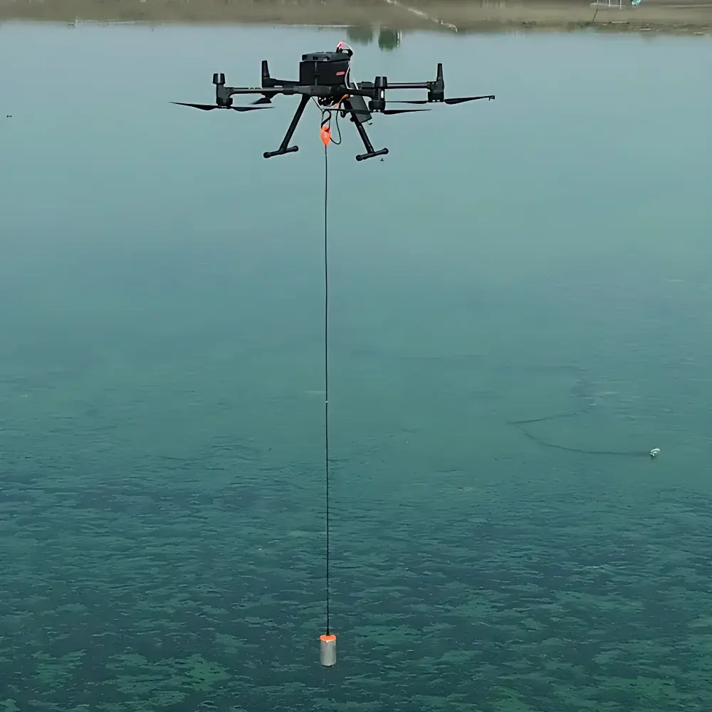
The AERO D052 Dual-Frequency Echo Sounder is an ultralightweight, submersible sonar instrument engineered for high-precision bathymetric mapping in dynamic and inaccessible aquatic environments. Based on pulse-echo time-of-flight acoustic ranging principles, the D052 transmits synchronized dual-frequency chirp signals at 50 kHz and 200 kHz—enabling simultaneous acquisition of deep-penetration (low-frequency) and high-resolution (high-frequency) depth profiles. Its compact form factor (460 g net weight) and IP68-rated housing support direct integration with unmanned surface vehicles (USVs), autonomous underwater vehicles (AUVs), remotely operated vehicles (ROVs), and fixed-platform deployments. Unlike conventional single-beam echosounders, the D052’s beam geometry—27° wide at 50 kHz for broad-area coverage and 7° narrow at 200 kHz for fine-scale bottom discrimination—provides adaptive vertical resolution across variable sediment types and water column conditions. The system operates under IEC 60945 maritime equipment standards and meets EN 62288 requirements for echo sounder performance verification.
Key Features
- True dual-frequency operation (50 kHz / 200 kHz) with independent transmit/receive channels for concurrent shallow and deep profiling
- Integrated dual-axis tilt sensor (roll & pitch) with ±90° range and 0.1° angular resolution—enabling real-time motion compensation without external IMU
- High-stability temperature sensor (0.1°C resolution) co-located with transducer for sound velocity correction in situ
- Submersible design rated to 200 m depth (IP68), validated per ISO 17662-2 for hydrographic instrumentation durability
- Configurable output rate up to 20 Hz, supporting high-speed UAV-based surveying at ground speeds >8 m/s
- Multi-protocol digital interface: RS-232 (default), RS-422 (long-cable noise immunity), and optional Ethernet for NMEA 0183 / NMEA 2000 / custom binary packet streaming
Sample Compatibility & Compliance
The D052 is compatible with freshwater, brackish, and seawater environments—including turbid, polluted, or fast-flowing rivers where traditional acoustic methods suffer from signal attenuation or multipath interference. Its dual-frequency architecture mitigates bottom reverberation effects common in silty or vegetated substrates. All firmware and data logging modules comply with GLP-aligned audit trail requirements; raw echo waveform storage supports post-processing traceability per ISO/IEC 17025 calibration documentation protocols. The device satisfies mandatory electromagnetic compatibility (EMC) testing per EN 61000-6-2 and EN 61000-6-4, and its acoustic output power adheres to ICES-2022 guidelines for marine mammal safety in near-shore surveys.
Software & Data Management
AERO provides the D052 Control Suite—a cross-platform application (Windows/macOS/Linux) supporting real-time display, configuration, and NTRIP-corrected GNSS synchronization. Raw depth samples are timestamped with microsecond precision using internal GPS PPS input. Data exports include CSV (depth + tilt + temp), GeoTIFF-ready XYZ grids, and industry-standard S7K (Kongsberg) binary format for interoperability with QPS Qimera, CARIS HIPS, and Fledermaus. Firmware updates maintain backward compatibility and include optional FDA 21 CFR Part 11-compliant electronic signature modules for regulated environmental monitoring workflows.
Applications
- High-resolution riverbed morphodynamics monitoring in flood-prone or contaminated watersheds
- Pre- and post-dredging verification for port authority compliance reporting
- ROV/AUV navigation aid and obstacle avoidance via real-time bathymetric SLAM integration
- Shoreline erosion assessment using repeat UAV-borne transects with <±2 cm vertical repeatability
- Underwater infrastructure inspection (pipelines, bridge pilings, dam foundations) with integrated tilt-compensated profiling
- Environmental impact assessments requiring ISO 14001-aligned acoustic survey documentation
FAQ
Does the D052 require external GNSS or inertial navigation for accurate georeferencing?
No—while external RTK-GNSS or AHRS inputs improve absolute positioning accuracy, the D052 delivers relative bathymetric consistency within ±0.5% of full scale using only its internal timing and tilt compensation algorithms.
Can the 50 kHz and 200 kHz channels be operated independently?
Yes—firmware allows asynchronous triggering, staggered pulse repetition intervals, and channel-specific gain/sensitivity tuning to optimize signal-to-noise ratio for specific sediment or water column conditions.
Is raw echo waveform data accessible for spectral analysis?
Yes—binary waveform dumps (16-bit ADC samples at 2 MHz sampling rate) are available via Ethernet interface for advanced backscatter classification or machine learning-based substrate identification.
What calibration documentation is provided with each unit?
Each D052 ships with a factory calibration certificate traceable to NIST-accredited acoustic standards, including transducer sensitivity, beam pattern characterization, and temperature/tilt sensor linearity test reports.
How is firmware updated, and is version rollback supported?
Updates are performed via secure HTTPS endpoint or local USB drive; full version history and signed rollback packages are retained in onboard non-volatile memory for audit compliance.


