AERO ECT400 Compact Echo Sounder
| Brand | AERO |
|---|---|
| Origin | Beijing, China |
| Manufacturer Type | Authorized Distributor |
| Country of Origin | China |
| Model | ECT400 |
| Price | USD 69,500 (FOB Beijing) |
| Net Weight | 275 g (transducer only), 1.6 kg (full system with housing & electronics) |
| Operating Temperature Range | −10 °C to +50 °C |
| Transducer Frequency | 450 kHz |
| Depth Measurement Range | 0.15–100 m (customizable up to 1000 m) |
| Depth Resolution | 1 mm |
| Depth Accuracy | ±0.2% of full scale |
| Temperature Sensor Resolution | 0.1 °C |
| Tilt Sensor Resolution | 0.1° |
| GPS Integration | NMEA 0183/RS232 output with automatic timestamping and georeferencing |
| Response Time (depth) | <50 ms |
| Backscatter Sensitivity | −80 dB to +20 dB dynamic range |
Overview
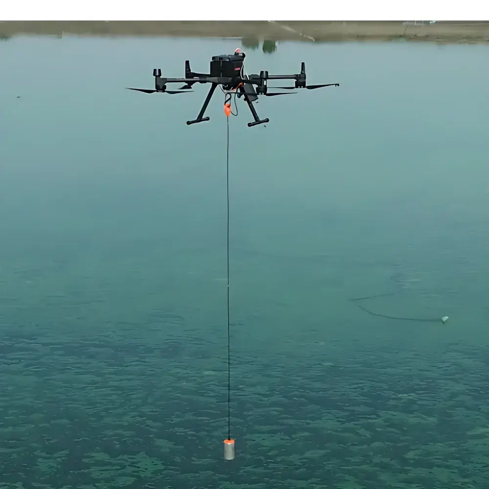
The AERO ECT400 is a compact, high-frequency echo sounder engineered for precision bathymetric profiling in demanding aquatic environments. Based on pulse-echo ultrasonic principle at 450 kHz, the ECT400 emits short-duration acoustic pulses and precisely measures the two-way travel time of returning echoes from the water surface, seabed, or suspended sediment layers. Its narrow beamwidth (±1.5° typical) ensures high spatial resolution and minimal side-lobe interference—critical for accurate detection of fine-scale bathymetric features, bridge pier scour morphology, and thin sediment layers. Designed for integration into unmanned platforms—including UAVs, ROVs, and AUVs—the ECT400 delivers real-time depth and calibrated backscatter intensity data synchronized with GNSS position, pitch/roll attitude, and water temperature. Unlike legacy single-beam echosounders requiring vessel-based deployment, the ECT400 supports rapid, risk-mitigated surveys over hazardous, inaccessible, or environmentally sensitive waters—including turbid rivers, industrial effluent zones, and shallow estuaries.
Key Features
- Ultra-compact transducer assembly (275 g) with integrated electronics housing (total system weight: 1.6 kg), enabling seamless integration on small UAVs and micro-ROVs.
- High-resolution depth measurement: 1 mm resolution with ±0.2% full-scale accuracy across the standard 0.15–100 m range; optional firmware and transducer variants support extended ranges up to 1000 m.
- Simultaneous acquisition of depth, calibrated backscatter amplitude, tilt (0.1° resolution), water temperature (0.1 °C resolution), and GNSS-derived position/time stamps.
- Low-power operation compatible with 12–24 V DC input; average power draw <2.5 W during active sounding cycles.
- Robust IP68-rated enclosure rated for continuous submersion at depths up to 100 m (transducer head); operating temperature range: −10 °C to +50 °C.
- Real-time data streaming via RS232/RS422 serial interface supporting NMEA 0183 and proprietary binary protocols; configurable output rates up to 20 Hz.
Sample Compatibility & Compliance
The ECT400 is optimized for freshwater and brackish environments but operates reliably in seawater with appropriate salinity compensation applied in post-processing. It complies with IEC 60945:2020 (Maritime navigation and radiocommunication equipment) for electromagnetic compatibility and environmental robustness. Data integrity meets GLP-aligned traceability requirements: all raw timestamps are hardware-synchronized to UTC via GNSS PPS signal; internal non-volatile memory retains configuration and calibration metadata. While not certified for Class I Div 1 hazardous locations, the unit satisfies CE marking for EMC Directive 2014/30/EU and RoHS 2011/65/EU. For regulatory workflows involving USACE, EPA, or ISO 4463-2 (hydrographic surveying), raw .bin and .csv outputs are fully compatible with QGIS, CARIS HIPS & SIPS, and ENVI processing pipelines.
Software & Data Management
AERO provides the ECT400 Control Suite—a cross-platform (Windows/macOS/Linux) application for real-time monitoring, configuration, and field validation. The suite supports live depth/backscatter visualization, tilt-compensated profile correction, and automated georeferenced export in GeoTIFF, XYZ, and LAS formats. All data files include embedded EXIF-style metadata (sensor model, firmware version, calibration date, GNSS fix quality). For enterprise deployments, the ECT400 supports MQTT and OPC UA gateways to feed time-series depth metrics into SCADA or cloud-based digital twin platforms. Audit trails—including parameter changes, firmware updates, and operator login events—are logged per FDA 21 CFR Part 11–compliant principles when configured with external authentication servers.
Applications
- Airborne Bathymetry: Paired with UAVs equipped with terrain-following radar and RTK-GNSS, enables centimeter-level vertical accuracy in riverine and lacustrine surveys—even under canopy or in GPS-challenged canyons.
- Submerged Infrastructure Monitoring: Quantifies scour depth around bridge piers, dam abutments, and offshore wind turbine foundations using repeat-pass differential analysis.
- Sediment Transport Studies: High-frequency backscatter profiles correlate with suspended sediment concentration (SSC), supporting calibration of hydrodynamic-sediment models (e.g., Delft3D, MIKE 21).
- Port & Harbor Safety: Real-time depth verification for draft-limited vessel navigation; integration with AIS and VTS systems via standardized NMEA overlays.
- Tidal & Wave Analysis: Sub-second depth sampling resolves wave-by-wave surface elevation, enabling spectral analysis of swell propagation and nearshore energy dissipation.
FAQ
What is the maximum recommended altitude for UAV-mounted ECT400 operation?
For optimal signal-to-noise ratio and beam footprint control, the recommended operational altitude is ≤30 m above water surface. At 450 kHz, the beam spreads to ~0.5 m diameter at 30 m range—sufficient for detecting localized scour features while maintaining survey efficiency.
Does the ECT400 support dual-frequency or multi-beam configurations?
No. The ECT400 is a single-beam, fixed-frequency (450 kHz) system. Multi-frequency or fan-beam capability requires the AERO ECT800 series, which shares mechanical mounting interfaces but uses separate transducer arrays and processing firmware.
Can raw echo waveform data be exported for custom signal processing?
Yes. The ECT400 firmware includes a developer mode enabling full I/Q waveform capture at 10 MHz sampling rate, stored in IEEE 754-compliant binary format with precise time alignment to GNSS PPS.
Is factory recalibration required annually?
Calibration certificates are issued with each unit (traceable to NIM, China). Recalibration is recommended every 24 months or after exposure to shock exceeding 50 g, immersion beyond rated depth, or replacement of the transducer cable assembly.


