AERO EM38-MK2 Airborne Electromagnetic Conductivity Sensor
| Brand | AERO |
|---|---|
| Origin | Beijing, China |
| Manufacturer Type | Authorized Distributor |
| Country of Origin | China |
| Model | EM38-MK2 |
| Detection Parameters | Dual-frequency electromagnetic induction (EC and magnetic susceptibility) |
| Portability | Airborne & Ground-portable |
| Application Environment | Field-deployable for aerial and terrestrial geophysical surveys |
| Electrical Conductivity Range | 0–1000 mS/m (4-digit resolution) |
| TDS Equivalent Range | ±28 ppt at 1-m coil separation |
| Accuracy | ±0.1% of full scale |
| Coil Separations | 1.0 m and 0.5 m (dual independent dipole receivers) |
| Operating Frequency | 14.5 kHz |
| Weight | 5.4 kg |
| Compliance | Designed for ISO 11277-compliant soil characterization workflows and ASTM D6439-22 (Standard Guide for Use of Electromagnetic Induction Methods in Geotechnical Investigations) |
Overview
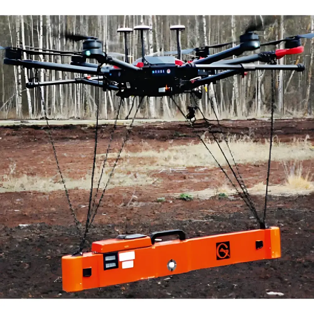
The AERO EM38-MK2 Airborne Electromagnetic Conductivity Sensor is a dual-coil, frequency-domain electromagnetic induction (EMI) instrument engineered for rapid, non-invasive mapping of near-surface soil electrical conductivity (EC) and apparent magnetic susceptibility. Based on the proven grounded-loop and airborne-capable EMI principle, the EM38-MK2 operates at a fixed excitation frequency of 14.5 kHz and employs two physically independent dipole receiver configurations—1.0 m and 0.5 m inter-coil separations—to simultaneously acquire two depth-sensitive conductivity profiles. This dual-depth capability enables vertical stratification analysis without physical soil penetration, supporting depth-weighted estimation of EC down to 1.5 m in typical loam-to-clay soils. Unlike contact-based four-electrode resistivity meters, the EM38-MK2 measures the secondary magnetic field induced by eddy currents in conductive subsurface materials, making it inherently insensitive to electrode contact resistance and ideal for rapid reconnaissance over large agricultural or infrastructure corridors.
Key Features
- Dual independent dipole receiver system with fixed 1.0 m and 0.5 m coil separations—enabling simultaneous shallow and intermediate-depth EC profiling
- High-stability 14.5 kHz sinusoidal transmitter with temperature-compensated oscillator circuitry for long-term measurement repeatability
- 4-digit digital output for EC (0–1000 mS/m), calibrated traceably to NIST-traceable conductivity standards
- Airborne-integrated mechanical design: lightweight (5.4 kg), IP65-rated enclosure, and vibration-damped mounting interface compatible with UAV gimbal systems and helicopter skid mounts
- Field-calibrated TDS equivalency: ±28 ppt uncertainty at 1-m configuration and ±7 ppt at 0.5-m configuration, referenced to standard NaCl solutions per ASTM D1125
- Full-scale accuracy of ±0.1%, validated across environmental temperature ranges from −10 °C to +50 °C
Sample Compatibility & Compliance
The EM38-MK2 is optimized for in situ, bulk-scale geophysical assessment of unconsolidated earth materials—including agricultural topsoil, alluvial sediments, compacted road subgrades, and engineered earthen embankments. It does not require sample preparation, extraction, or laboratory digestion. Its electromagnetic response correlates empirically with soluble salt content, clay fraction, moisture distribution, and ferromagnetic mineral concentration—parameters routinely evaluated under ISO 11277 (soil description and sampling), ASTM D6439-22 (EMI application guidance), and FAO’s Global Soil Partnership protocols. While not a certified reference method for regulatory reporting, its data are widely accepted as screening-grade input for GLP-aligned site characterization programs, particularly when cross-validated with point measurements (e.g., 1:5 soil:water EC extracts per ISO 11265).
Software & Data Management
Raw EM38-MK2 outputs are delivered as ASCII-encoded time-series datasets containing synchronized EC0.5m, EC1.0m, internal temperature, and GPS timestamp fields (when interfaced with external GNSS). AERO provides the proprietary EM-Studio Suite v3.x for post-processing, including spatial interpolation (IDW, kriging), depth-constrained inversion modeling (1D laterally constrained inversion), and export to GIS-ready formats (GeoTIFF, Shapefile, CSV with WKT geometry). All software modules comply with FDA 21 CFR Part 11 requirements for audit trail logging, electronic signature support, and data integrity controls—making them suitable for QA/QC documentation in civil engineering due diligence and environmental baseline studies.
Applications
- Large-area soil salinity mapping for precision irrigation scheduling and drainage design in arid-zone agriculture
- Detection of preferential seepage pathways and internal erosion zones within earth-fill dams and levees
- Subsurface void and anomaly identification beneath paved roadways and airport runways during routine infrastructure health monitoring
- Geological mapping of sedimentary layer boundaries, paleochannel identification, and bedrock depth estimation in regolith-covered terrains
- Pre-excavation utility corridor scanning and archaeological prospection where minimal ground disturbance is mandated
FAQ
Does the EM38-MK2 measure true resistivity or apparent conductivity?
It reports apparent electrical conductivity (ECa) in mS/m, derived from the quadrature component of the induced secondary magnetic field. Inversion to true formation resistivity requires ancillary information (e.g., topography, known lithology) and is supported via optional 1D modeling modules.
Can it be used in wet or frozen soil conditions?
Yes—its non-contact operation eliminates electrode freezing issues. However, surface water pooling or snow cover >5 cm may attenuate signal coupling and reduce effective depth of investigation.
Is factory recalibration required annually?
AERO recommends annual verification against certified reference coils and drift-check using stable saline phantoms. Full recalibration is performed only if verification exceeds ±0.15% deviation from baseline.
What GNSS compatibility does it support?
The sensor features RS-232/RS-422 TTL serial output and accepts NMEA 0183 GGA/GSA/RMC messages from any IGC-certified GNSS receiver with PPS timing sync.
How is magnetic susceptibility quantified?
Magnetic susceptibility is derived from the in-phase component of the received signal and reported as dimensionless SI susceptibility (×10−5), normalized to coil geometry and calibrated using geological standards (e.g., magnetite-doped sand columns).
Related Products