AERO PTA High-Throughput Airborne Phenotyping Measurement System
| Brand | AERO |
|---|---|
| Origin | Beijing, China |
| Manufacturer Type | Authorized Distributor |
| Country of Origin | China |
| Model | PTA |
| Pricing | Available Upon Request |
Overview
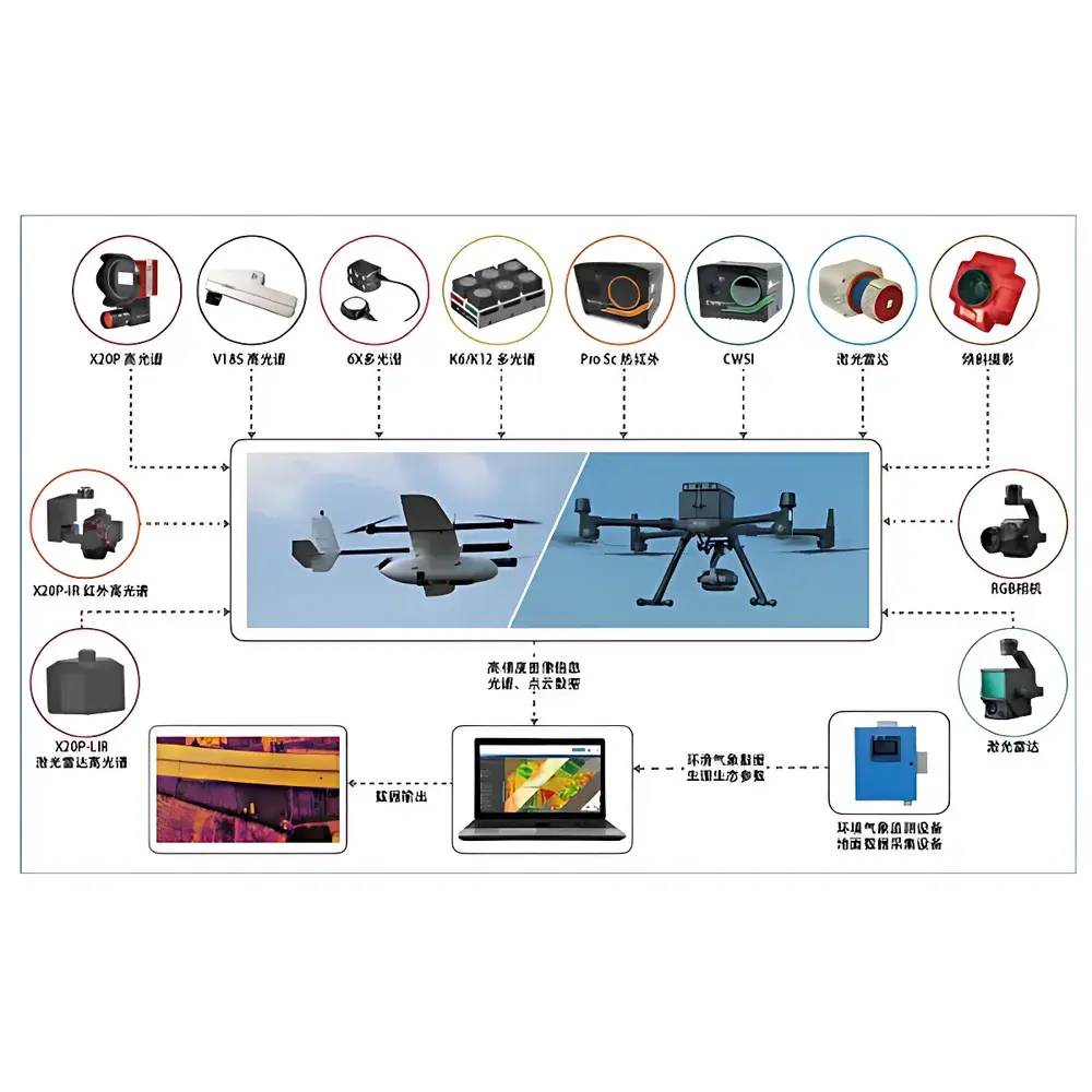
The AERO PTA High-Throughput Airborne Phenotyping Measurement System is an integrated remote sensing platform engineered for non-destructive, field-scale acquisition of quantitative plant phenotypic traits. It operates on the principle of multi-modal airborne optical and structural sensing—combining hyperspectral imaging (HSI), multispectral imaging (MSI), thermal infrared (TIR) radiometry, and light detection and ranging (LiDAR)—to extract morphological, physiological, and biochemical parameters from standing vegetation under natural field conditions. Unlike ground-based or greenhouse phenotyping systems, the PTA leverages vertical take-off and landing (VTOL) UAV architecture to achieve consistent spatial coverage across heterogeneous agricultural plots, enabling reproducible measurements at canopy, plot, and landscape scales. Its design aligns with FAO and CGIAR frameworks for scalable phenomics, supporting genotype-by-environment (G×E) interaction analysis through time-series data capture under real-world agronomic management.
Key Features
- Modular VTOL UAV platforms: A660 heavy-lift hexacopter or AZCW fixed-wing hybrid system, both certified for >60 min endurance and ≥5 kg payload capacity under ISO 21320-1 operational constraints
- Multi-sensor interoperability: Seamless integration of V185/X20P snapshot hyperspectral imagers (400–1000 nm, 2.5 nm spectral resolution), K6 research-grade multispectral sensors (5–12 discrete bands), Pro Sc dual-lens thermal cameras (7.5–14 µm, NETD < 40 mK), and AZ-LiDAR modules (≤2 cm vertical accuracy, 100+ pts/m² density)
- Georeferenced data acquisition: RTK-GNSS (centimeter-level horizontal positioning) and IMU-assisted motion compensation ensure sub-pixel registration across modalities
- Onboard preprocessing: Real-time radiometric calibration, geometric correction, and orthomosaic stitching via embedded FPGA-accelerated pipelines
- Ruggedized field deployment: IP54-rated payload bay, -10°C to +45°C operating range, and compliance with IEC 60529 environmental protection standards
Sample Compatibility & Compliance
The PTA system is validated for use across major cereal, legume, and oilseed crops—including maize, wheat, soybean, rice, and sorghum—at vegetative, reproductive, and grain-filling stages. It supports measurement of key traits defined in the Plant Ontology (PO) and Crop Ontology (CO), such as canopy height (via LiDAR-derived digital surface models), stomatal conductance proxies (from TIR-derived canopy temperature differentials), chlorophyll content (NDVI, PRI, CIred-edge from MSI/HSI), and biomass accumulation (structural volume from point cloud segmentation). All sensor outputs conform to ASTM E2912-22 (Standard Practice for Hyperspectral Imaging Data Collection) and ISO 11727:2021 (Remote Sensing—Data Quality Metrics for Vegetation Indices). The system architecture meets GLP-aligned audit trail requirements for field trial documentation, including timestamped metadata embedding per frame (EXIF XMP schema) and secure onboard storage (AES-256 encrypted microSD).
Software & Data Management
AERO Phenotype Studio (APS) v4.x serves as the unified processing environment, supporting batch calibration, co-registration, spectral unmixing, and trait extraction workflows. APS implements FAO-recommended vegetation index algorithms (e.g., MCARI/OSAVI for chlorophyll estimation; CWSI for water stress quantification) and integrates with R-based breedR and Python-powered DeepPheno libraries for machine learning–driven trait modeling. Raw data exports comply with NetCDF-4/HDF5 standards for interoperability with AgriStack, BreedBase, and Gramene databases. Audit logs record all processing steps—including user ID, timestamp, parameter settings, and version-controlled code references—to satisfy FDA 21 CFR Part 11 electronic record integrity requirements for regulated breeding programs.
Applications
- Large-area crop phenotyping trials for yield prediction and drought tolerance screening
- Dynamic monitoring of nitrogen use efficiency (NUE) and photosynthetic performance across growth stages
- High-resolution mapping of disease incidence (e.g., rust, blight) using spectral anomaly detection
- Root-zone soil moisture inference via canopy temperature–vapor pressure deficit (VPD) coupling analysis
- Support for QTL mapping and genomic selection pipelines through spatiotemporally resolved trait matrices
- Validation of satellite-derived vegetation indices (e.g., Sentinel-2, Landsat 9) at field scale
FAQ
What regulatory standards does the PTA system support for field trial documentation?
The system complies with ISO 21320-1 (UAV operational safety), ASTM E2912-22 (hyperspectral data collection), and embeds audit trails meeting FDA 21 CFR Part 11 requirements for electronic records in GxP environments.
Can PTA data be integrated into existing breeding informatics platforms?
Yes—APS exports NetCDF-4/HDF5 files with CF-compliant metadata, enabling direct ingestion into BreedBase, T3, and Gramene. APIs support automated sync with LIMS and ELN systems.
Is real-time data transmission supported during flight?
Telemetry and low-bandwidth preview streams are available via LTE/5G uplink; however, full-resolution sensor data is stored locally to ensure integrity and bandwidth independence in remote field locations.
How is sensor calibration maintained across seasonal deployments?
Each sensor module includes NIST-traceable reflectance panels and blackbody references. APS enforces pre-flight dark-current and white-reference acquisitions, with calibration coefficients archived per mission in immutable metadata.
Does the system support autonomous flight planning for repeated surveys?
Yes—mission plans can be scripted in APS using KML-defined plot boundaries and geofence constraints, with auto-recovery protocols triggered by GNSS signal loss or battery thresholds.
Related Products