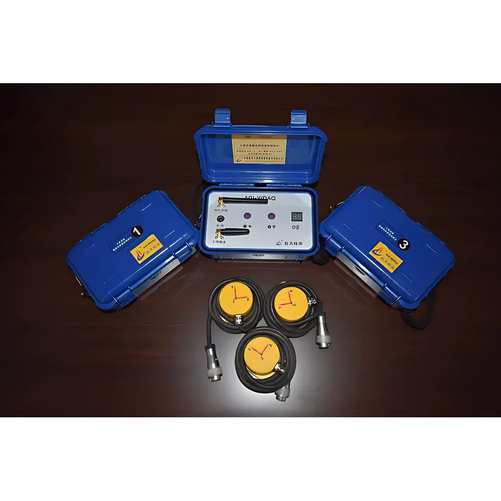
AGI-T3 Wireless 3D Seismic Imaging Tunnel Geological Prediction System
| Origin | Yunnan, China |
|---|---|
| Manufacturer Type | Authorized Distributor |
| Origin Category | Domestic (China) |
| Model | AGI-T3 |
| Pricing | Upon Request |
Overview
The AGI-T3 Wireless 3D Seismic Imaging Tunnel Geological Prediction System is an advanced geophysical instrument engineered for real-time, high-resolution pre-excavation geological characterization in tunneling projects. It operates on the physical principles of multi-component, multi-wave reflection seismology—specifically leveraging P-wave and S-wave propagation, reflection, and scattering phenomena in heterogeneous rock mass. Unlike conventional single-point or 2D profiling methods, the AGI-T3 implements a true spatial three-point localization algorithm, enabling direct 3D reconstruction of seismic wavefronts from distributed source–receiver geometry within confined tunnel environments. The system deploys elastic wave excitation (via controlled hammer impact or small-charge explosive sources) along both sidewalls of the tunnel face, while synchronized wireless sensor arrays capture reflected and diffracted energy returning from subsurface discontinuities—including fault zones, karst cavities, fractured zones, and lithological boundaries. By analyzing first-arrival times, amplitude envelopes, and velocity-dependent phase characteristics, the AGI-T3 generates volumetric structural models with meter-scale spatial resolution, supporting proactive risk mitigation during TBM or drill-and-blast excavation.
Key Features
- Full wireless architecture: Eliminates cabling constraints—enabling simultaneous trigger synchronization and high-fidelity data transmission across up to 48 distributed sensor nodes without latency or signal degradation.
- Multi-source flexibility: Compatible with both mechanical impact (sledgehammer-based) and low-energy explosive sources, allowing field adaptation to safety regulations, noise restrictions, and site access conditions.
- Direct P- and S-wave 3D imaging: Built upon rigorous three-point spatial localization theory, delivering native vectorized wavefield reconstruction without post-hoc interpolation or tomographic inversion assumptions.
- FK-domain 2D filtering & signal equalization: Applies frequency–wavenumber domain filtering combined with time-synchronized amplitude balancing to suppress ground roll, air-coupled noise, and tunnel wall reverberations—enhancing signal-to-noise ratio (SNR) of forward-scattered arrivals by ≥12 dB.
- Automated velocity scanning and stratification: Integrates iterative semblance-based velocity analysis with adaptive layer boundary detection, yielding depth-variant P- and S-wave velocity profiles essential for rock mass classification (e.g., RMR, Q-system) and support design calibration.
- Diffraction migration + Common Reflection Surface (CRS) stacking: Implements hybrid imaging workflow combining Kirchhoff diffraction migration with CRS superposition to resolve sub-wavelength scatterers and improve lateral continuity of interpreted features.
Sample Compatibility & Compliance
The AGI-T3 is validated for use in hard-rock, soft-ground, and mixed-face tunneling environments typical of highway, railway, and hydropower infrastructure projects. It complies with core geotechnical survey standards referenced in China’s Tunnel Construction Advanced Geological Forecasting Technical Specification (JGJ/T 405–2017). Data acquisition protocols align with ISO 22241-2 (seismic instrumentation performance criteria) and ASTM D7403 (standard test method for seismic refraction and reflection surveys). While not FDA- or GLP-regulated, its metadata-rich output structure—including precise timestamping, GPS-referenced positioning logs, and source/receiver geometry files—supports audit-ready documentation for QA/QC workflows under ISO 9001:2015 and EN 1536:2019 (piling and underground works).
Software & Data Management
The AGI-T3 is operated via AGIView™ v4.x, a Windows-based platform supporting real-time acquisition monitoring, interactive FK-filter tuning, velocity spectrum visualization, and 3D volume rendering using OpenGL-accelerated voxel engines. All raw and processed datasets are stored in open HDF5 format with embedded XML metadata headers compliant with the SEG-Y Rev 2.1 standard extension for near-surface applications. Software includes built-in trace-level QC flags, automatic gain recovery, and export modules for interoperability with industry-standard platforms including Petrel Geophysics, GOCAD, and Phase2. Audit trails record operator actions, parameter modifications, and processing sequence history—supporting traceability requirements for third-party review and regulatory submissions.
Applications
- Predrill assessment of fault zones, collapse columns, and tectonic breccia belts ahead of tunnel face
- Karst cavity detection and volumetric estimation in carbonate formations
- Quantitative rock mass velocity profiling for dynamic modulus estimation and blast design optimization
- Verification of grouting effectiveness behind lining segments via time-lapse velocity change mapping
- Integration with BIM-enabled construction management systems for 4D scheduling of hazard-responsive excavation sequences
FAQ
What types of seismic sources are supported?
The AGI-T3 supports both non-explosive (hand-held sledgehammer with calibrated force transducer) and low-yield explosive sources (≤50 g TNT equivalent), with configurable trigger thresholds and delay compensation.
Is the system suitable for curved or inclined tunnels?
Yes—the wireless node layout and coordinate transformation engine accommodate variable tunnel geometry; users input curvature radius and inclination angle during setup to maintain spatial fidelity in migrated volumes.
How is data quality assured during acquisition?
Real-time SNR monitoring, automatic coherence thresholding, and redundant trigger validation across ≥3 reference sensors ensure only valid waveforms enter the imaging pipeline.
Does the system meet international reporting standards for geotechnical due diligence?
Output deliverables include SEG-Y-compliant traces, velocity-depth models in ASCII/CSV, and annotated 3D PDF reports—all structured to satisfy IEC 61508 SIL2-aligned reporting frameworks used in major infrastructure lenders’ technical reviews.


")