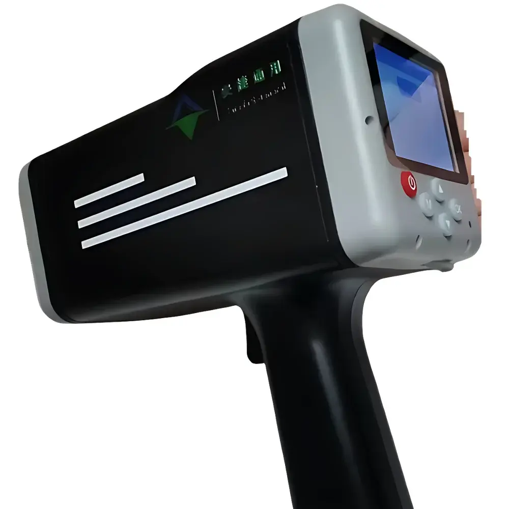
Agilent General AT-RDLS10 Handheld Radar Velocity Sensor
| Brand | Agilent General (Safe, Fast, General) |
|---|---|
| Origin | Beijing, China |
| Manufacturer Type | OEM Manufacturer |
| Origin Category | Domestic |
| Model | AT-RDLS10 |
| Price | USD 2,800 (FOB) |
Overview
The Agilent General AT-RDLS10 Handheld Radar Velocity Sensor is a portable, non-contact surface velocity measurement instrument engineered for field deployment in open-channel hydrometric applications. It operates on the principle of continuous-wave Doppler radar at 24 GHz (K-band), emitting a narrow 12° beam to detect the Doppler shift induced by moving water surfaces—enabling accurate surface velocity estimation without physical immersion or mechanical contact. Designed for operational safety and environmental resilience, the device eliminates risks associated with wading, unstable banks, or hazardous effluent exposure. Its core architecture integrates real-time angular compensation via an embedded dual-axis inclinometer and temperature monitoring via an onboard thermistor, ensuring velocity corrections for both pitch and yaw deviations as well as thermal drift. The instrument complies with IEC 60529 (IP67 ingress protection) and meets electromagnetic compatibility requirements per EN 61326-1 for industrial environments.
Key Features
- Ultra-portable design: Weighs less than 700 g; ergonomically balanced for one-handed operation during extended field surveys.
- True plug-and-play operation: No calibration or setup required—automatic horizontal/vertical angle compensation initiated upon power-on.
- Robust environmental rating: IP67-rated housing constructed from high-impact ABS resin, offering resistance to UV degradation, thermal cycling (–20 °C to +70 °C), chemical corrosion (including H₂S-laden wastewater), and mechanical shock.
- Dual-mode acquisition: Supports single-shot measurement (100.0 s integration) and continuous acquisition (up to 3000 s), with configurable averaging intervals for statistical robustness.
- Onboard data management: Internal flash memory stores up to 2,000 timestamped velocity records, each tagged with GPS-optional metadata (via Bluetooth pairing), inclination angles, ambient temperature, and signal quality indicators.
- Integrated power system: Rechargeable Li-ion battery provides ≥15 hours of continuous operation under typical duty cycles; charging via micro-USB compliant with IEC 62368-1 safety standards.
Sample Compatibility & Compliance
The AT-RDLS10 is validated for velocity profiling across heterogeneous flow media—including turbulent river surfaces, sediment-laden stormwater runoff, viscous sewage effluents, and saline coastal waters—without signal attenuation from suspended solids or biofouling. It conforms to ASTM D3858-22 (Standard Practice for Measuring Surface Velocity of Open Channels Using Radar) and supports traceable measurement workflows aligned with ISO/IEC 17025:2017 clause 7.7 (uncertainty evaluation). All firmware and data logging routines are designed to support audit-ready documentation for regulatory reporting under EPA Method 1604 and EU WFD (Water Framework Directive) Annex V compliance frameworks.
Software & Data Management
The optional Agilent FlowLink™ Wireless Measurement Suite (v3.2+) enables real-time telemetry via Bluetooth 5.0 LE, supporting synchronized multi-point surface velocity capture and cross-sectional discharge estimation using standard hydraulic algorithms (e.g., mid-section, mean-section, and index-velocity methods). Export formats include CSV, GeoJSON, and PDF reports compliant with GLP/GMP documentation requirements. Software features include automatic uncertainty propagation per GUM (JCGM 100:2008), digital signature-enabled report generation, and 21 CFR Part 11–compatible user authentication and electronic audit trails when deployed on validated Windows-based tablets.
Applications
- Real-time flood response monitoring during emergency hydrological events (e.g., levee breach assessment, dam release tracking)
- Routine wastewater treatment plant inflow/outflow verification under NPDES permit conditions
- Construction site sediment control validation (e.g., SWPPP compliance near bridge piers or culverts)
- Ecological flow assessment in regulated streams and irrigation canals
- Calibration and validation of permanent acoustic Doppler current profilers (ADCPs) and stage-discharge rating curves
- Marine port operations: tidal current mapping and dockside velocity profiling for vessel maneuvering safety
FAQ
What is the maximum effective measurement distance under adverse weather conditions?
Under light rain or fog (visibility >50 m), the AT-RDLS10 maintains reliable detection up to 85 m; performance degrades gradually beyond 100 m due to atmospheric attenuation at 24 GHz.
Does the device require annual factory recalibration?
No—its K-band radar module is solid-state with no moving parts or consumables; routine verification against a certified reference velocity source (e.g., calibrated rotating disc) every 12 months satisfies ISO/IEC 17025 maintenance requirements.
Can the instrument be used for submerged or bottom-velocity measurements?
No—it measures only surface velocity via reflected microwave energy; subsurface profiling requires complementary ADCP or electromagnetic flow sensor integration.
Is the internal data logger compatible with third-party GIS platforms?
Yes—CSV exports include WGS84 coordinates (when paired with external GNSS), velocity vectors, and metadata fields mapped to OGC Simple Features schema for direct ingestion into QGIS, ArcGIS Pro, or HydroDesktop.
How is measurement uncertainty quantified in field reports?
Uncertainty components include Doppler resolution (±0.01 m/s), angular compensation error (±0.3°), temperature-induced oscillator drift (±0.005 m/s/°C), and surface reflectivity variance—combined using root-sum-square methodology per GUM Annex E.
Related Products