AZ-S0210 Soil Hydromechanical–Thermal–Solute Coupled Transport Monitoring System
| Brand | AZ (Beijing Aozuo) |
|---|---|
| Origin | Germany |
| Manufacturer | Yes |
| Country of Origin | Imported |
| Model | AZ-S0210 |
| Instrument Type | Contaminant Transport Analyzer |
| Key Parameters | In-situ multi-depth soil water content, matric potential, temperature, and pore-water solute extraction (NO₂⁻, NO₃⁻+NO₂⁻, PO₄³⁻, SiO₄⁴⁻, NH₄⁺, Ca²⁺, Cl⁻, Fe²⁺/³⁺, total P, total N, SO₄²⁻, alkalinity, hardness, Cr(VI), CN⁻, N₂H₄, volatile phenols) |
| Sampling Frequency | Configurable from 1 s to 24 h per sensor channel |
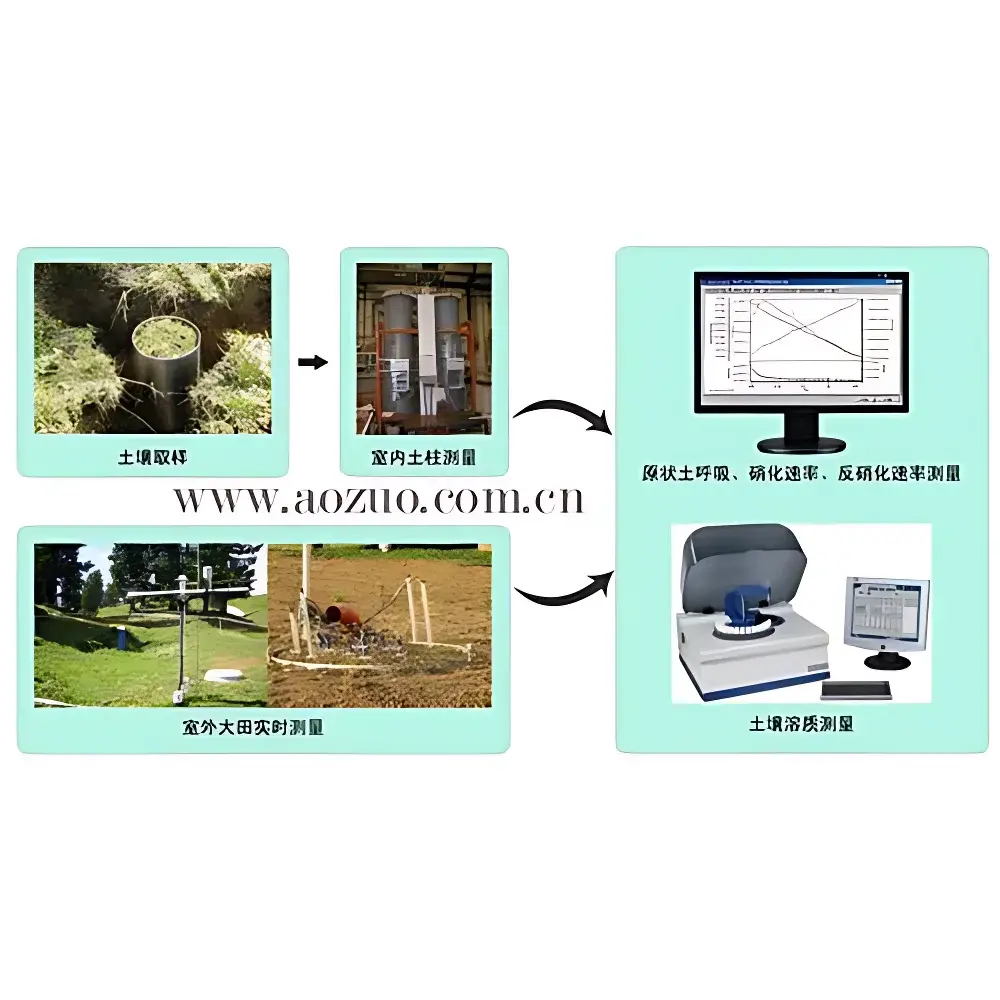
| Sensor Depth Resolution | Field-scale intact monoliths (1 m Ø × 2 m depth) with sensors at 30, 60, 120, 180 cm |
Overview
The AZ-S0210 Soil Hydromechanical–Thermal–Solute Coupled Transport Monitoring System is an integrated field-deployable platform engineered for long-term, in-situ quantification of coupled water flow, thermal conduction, and reactive solute transport in unsaturated and saturated soil profiles. It operates on the physical basis of Darcy–Richards flow theory for variably saturated media, extended by Fourier’s law for heat conduction and Fickian–advection–dispersion–reaction equations for solute migration. Unlike conventional single-parameter soil monitoring systems, the AZ-S0210 explicitly resolves interdependent feedbacks—such as evaporation-driven thermal gradients altering hydraulic conductivity, or salt-induced osmotic potential shifts modifying water retention curves—thereby enabling mechanistic modeling of non-equilibrium transport under realistic boundary conditions. Designed for deployment in heterogeneous field settings—including arid-zone salinization zones, agricultural lysimeters, riparian floodplains, and contaminated brownfield sites—the system supports validation of advanced numerical simulators (e.g., HYDRUS-1D/2D, STANMOD, PFLOTRAN) against high-resolution empirical data.
Key Features
- Modular architecture supporting both field-scale intact soil monoliths (1 m diameter × 2 m depth) and laboratory-scale controlled columns (30 cm diameter × 30/60/120 cm height), each configurable with stratified sensor arrays.
- Patent-pending non-disturbing monolith excavation methodology eliminating edge-flow artifacts and preserving natural soil structure–hydraulic continuity at column boundaries.
- Multi-depth, co-located sensing: simultaneous measurement of volumetric water content (θ, via TDR/FDR), soil water matric potential (ψ, via tensiometers or ceramic suction sensors), and temperature (T, Pt100 or thermistor arrays) at up to five discrete horizons per profile.
- Automated, vacuum-assisted pore-water extraction system enabling sequential, low-suction (< −20 kPa) sampling of soil solution without compression-induced artifact or preferential flow bias.
- Flexible temporal resolution: independent programmable acquisition intervals per channel—from 1 second (for transient infiltration events) to 24 hours (for seasonal trend analysis)—with synchronized timestamping and metadata tagging.
- Integrated ion analysis module compatible with standard ICP-OES, IC, and colorimetric assay workflows for anion/cation speciation and redox-sensitive species (e.g., Cr(VI), Fe²⁺, NO₂⁻).
Sample Compatibility & Compliance
The AZ-S0210 accommodates undisturbed field monoliths across diverse pedological classes (sandy loam to heavy clay), including saline-sodic, organic-rich, and anthropogenically contaminated matrices. Its sensor suite complies with ISO 11277 (soil description), ASTM D5859 (in-situ water content), and ISO 22028-2 (reference materials for aqueous speciation). The pore-water extraction protocol adheres to EPA Method 1311 (TCLP) and ISO 10390 (soil solution sampling) for regulatory-grade contaminant mobility assessment. All electronics meet IEC 60529 IP67 ingress protection and operate within −20 °C to +60 °C ambient ranges, certified for continuous outdoor deployment under GLP-compliant audit trails.
Software & Data Management
Data acquisition is managed via a ruggedized industrial datalogger with embedded SD card storage, USB/RS-485/Ethernet interfaces, and optional LTE telemetry. Firmware supports user-defined trigger logic (e.g., initiate solute extraction upon rainfall >5 mm/h detected by co-located tipping-bucket gauge). Raw sensor outputs are converted using manufacturer-provided calibration polynomials traceable to NIST standards. Exported time-series datasets include full uncertainty propagation (±0.002 m³/m³ for θ, ±0.5 kPa for ψ, ±0.1 °C for T) and conform to CF-NetCDF v1.8 metadata conventions. Software tools include batch processing for flux calculation (using Buckingham–Darcy and Fourier formulations), solute retardation factor estimation, and export to MODFLOW-NWT or HP1 input formats.
Applications
- Quantifying deep percolation and contaminant leaching pathways in pesticide- or nitrate-impacted aquifer recharge zones (e.g., Bavarian State Office for Environment field study, Munich floodplain).
- Validating coupled hydrothermal–biogeochemical models in irrigated agroecosystems subject to cyclic wetting–drying and salinization (e.g., Heilongjiang Hydraulic Research Institute maize lysimeter project).
- Assessing capillary rise and evaporative salt accumulation dynamics in semi-arid soils for sustainable land reclamation planning.
- Supporting site-specific risk assessment under EU Soil Thematic Strategy and US EPA RCRA Subpart F requirements through defensible pore-water concentration–depth profiles.
- Providing boundary-condition inputs for reactive transport simulations of redox-sensitive contaminants (Cr(VI), As(III), CN⁻) in reducing alluvial sediments.
FAQ
Can the AZ-S0210 be used in frozen soils?
Yes—its Pt100 temperature sensors and low-temperature-rated tensiometers support operation down to −20 °C; however, pore-water extraction is suspended below 0 °C to prevent ice-blockage.
Is the system compliant with FDA 21 CFR Part 11 for regulated environmental monitoring?
Full electronic audit trail, user access control, and digital signature support are available via optional software license; hardware-level timestamping is NTP-synchronized and traceable to UTC(NIST).
How is sensor calibration maintained over multi-year deployments?
Each sensor batch includes factory calibration certificates with drift coefficients; field recalibration ports allow periodic verification using standard reference solutions (e.g., saturated CaSO₄ for water potential, NaCl solutions for EC-based solute proxies).
Does the system support real-time remote data access?
LTE-enabled configurations provide encrypted HTTPS API endpoints for live sensor status, alarm thresholds (e.g., ψ < −100 kPa), and scheduled data pull—compatible with custom dashboards or enterprise GIS platforms.
What level of technical support is provided for model integration?
AZ provides documented MATLAB and Python APIs for direct ingestion into HYDRUS and PFLOTRAN workflows, plus application engineering consultation for boundary condition mapping and parameter inversion setup.


