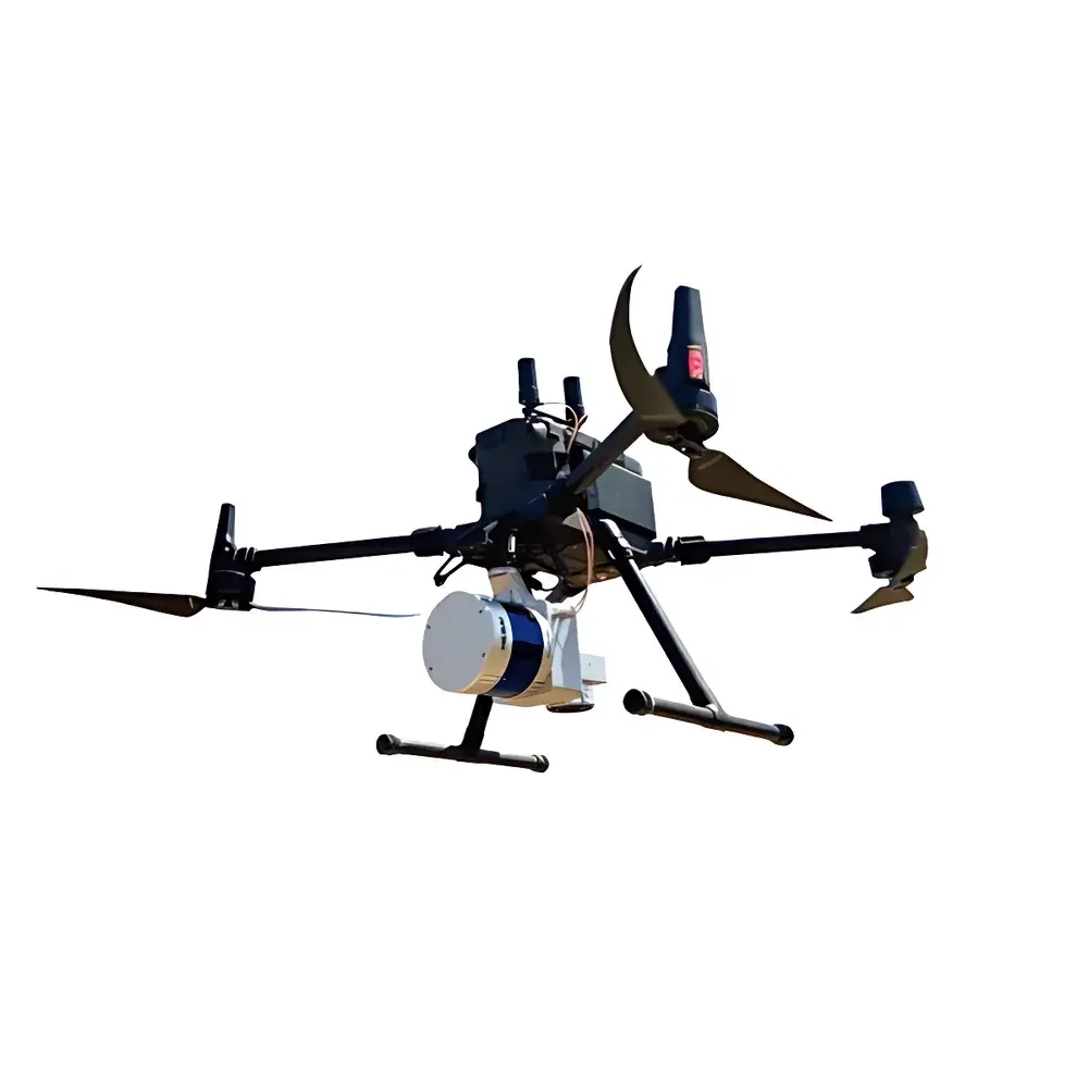
AZUP LiDAR 220N UAV-Mounted Light Detection and Ranging System
| Brand | AZUP |
|---|---|
| Origin | Beijing, China |
| Manufacturer Type | Original Equipment Manufacturer (OEM) |
| Country of Origin | China |
| Model | LiDAR 220N |
| Pricing | Upon Request |
Overview
The AZUP LiDAR 220N is a compact, UAV-integrated light detection and ranging (LiDAR) system engineered for high-accuracy 3D geospatial data acquisition from multi-rotor unmanned aerial platforms. Built upon time-of-flight (ToF) laser ranging principles, the system employs a 40-line rotating scanning mechanism operating at near-infrared wavelengths (typically 905 nm), enabling precise distance measurement through direct pulse emission and echo detection. Its integrated inertial navigation system (INS) — comprising a high-grade MEMS-based IMU synchronized with GNSS (GPS/GLONASS/Galileo/BeiDou) — delivers real-time position and attitude compensation, ensuring sub-decimeter horizontal and vertical accuracy in point cloud georeferencing. The co-mounted visible-light RGB camera supports synchronized image capture for photogrammetric enhancement, texture mapping, and visual validation of LiDAR-derived surfaces. Designed for operational robustness in field-deployed environmental monitoring, the LiDAR 220N meets mechanical and thermal stability requirements for sustained flight durations up to 45 minutes on typical commercial quadcopter platforms.
Key Features
- 40-channel rotating LiDAR sensor with ≥200 kHz total scan rate and adjustable vertical field-of-view (FOV) for adaptive terrain coverage
- Tightly coupled GNSS-INS navigation unit with RTK/PPK support, delivering ≤5 cm horizontal and ≤8 cm vertical positional accuracy (1σ, post-processed)
- Integrated 20-megapixel global-shutter RGB camera with hardware-synchronized trigger and geotagging capability
- Lightweight modular architecture (<2.1 kg total payload mass) optimized for Class II & III UAV platforms (e.g., DJI Matrice 300 RTK, Autel EVO Max 4T)
- Onboard data storage (dual SD card slots, up to 512 GB) with real-time telemetry and health monitoring via CAN/UART interface
- IP54-rated enclosure for dust and water resistance during low-altitude airborne operations in variable meteorological conditions
Sample Compatibility & Compliance
The LiDAR 220N is compatible with standard UAS airframes equipped with power delivery (24–36 V DC), CAN bus communication, and mounting interfaces compliant with ISO 13849-1 mechanical safety guidelines. It supports data output in industry-standard formats including LAS/LAZ (v1.4), E57, and PLY, ensuring interoperability with widely adopted GIS and photogrammetry software suites (e.g., ArcGIS Pro, Global Mapper, Pix4Dmapper, CloudCompare). The system adheres to electromagnetic compatibility (EMC) requirements per EN 61000-6-3 (Emission) and EN 61000-6-2 (Immunity), and conforms to laser safety Class 1 IEC 60825-1:2014 specifications under normal operating conditions. For regulatory deployment in EU, US, and APAC jurisdictions, it supports documentation packages aligned with ISO 19115 metadata standards and facilitates audit-ready data provenance logs required under GLP-compliant environmental survey workflows.
Software & Data Management
AZUP provides the proprietary LiDAR Studio Suite v3.x for raw data preprocessing, trajectory refinement, point cloud classification (ground/non-ground), and DSM/DTM generation. The software implements iterative closest point (ICP) registration algorithms and supports third-party integration via open APIs (RESTful endpoints and Python SDK). All processing workflows maintain full traceability: timestamps, sensor calibration coefficients (updated per mission), GNSS solution status flags, and INS bias estimates are embedded in metadata headers. Export modules comply with FDA 21 CFR Part 11 requirements for electronic records and signatures when configured for regulated environmental assessment applications. Data encryption (AES-256) and role-based access control (RBAC) are available in enterprise license tiers to meet ISO/IEC 27001-aligned information security policies.
Applications
- Power line corridor inspection: Automated detection of vegetation encroachment, tower deformation, and conductor sag analysis using classified ground and wire points
- Emergency rapid-response mapping: Generation of orthomosaic DEMs and contour maps within 2 hours of data acquisition for flood modeling or landslide assessment
- Forest structure inventory: Canopy height model (CHM) derivation, individual tree crown segmentation, and biomass estimation via allometric regression integration
- Coastal erosion monitoring: Multi-temporal change detection of shoreline position, dune morphology, and intertidal elevation shifts at ≤15 cm vertical resolution
- Archaeological site documentation: High-fidelity microtopographic reconstruction of buried features beneath vegetative cover using ground-return density optimization
FAQ
What is the maximum operational altitude above ground level (AGL) for the LiDAR 220N?
The system is validated for stable performance up to 120 m AGL under nominal atmospheric transmission conditions; optimal point density is achieved between 50–80 m AGL depending on terrain complexity.
Does the LiDAR 220N support real-time kinematic (RTK) positioning onboard?
Yes — the integrated GNSS receiver supports dual-frequency RTK output at 10 Hz via UART or CAN, enabling real-time centimeter-level positioning without post-processing dependency.
Is firmware update capability available over-the-air (OTA)?
Firmware updates require physical connection via USB-C and are performed using AZUP’s certified updater tool; OTA functionality is not implemented for cybersecurity and integrity assurance.
Can the system be calibrated in-field without returning to the manufacturer?
Yes — users may perform geometric boresight calibration (lever-arm and misalignment correction) using AZUP’s target-based calibration workflow, with results validated against NIST-traceable reference targets.
What level of point cloud classification automation does the software provide?
LiDAR Studio Suite includes rule-based and machine learning-assisted classifiers (e.g., Random Forest trained on ISPRS benchmark datasets) for ground, vegetation, building, and power line segmentation, with user-adjustable confidence thresholds.


