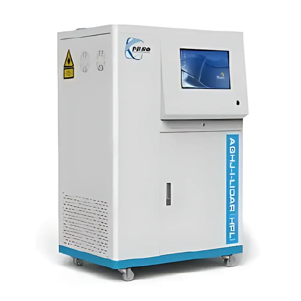
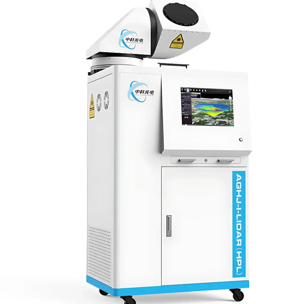
CASP AGHJ-I-LIDAR(HPL) High-Energy Scanning Atmospheric Aerosol Lidar
| Brand | CASP |
|---|---|
| Origin | Jiangsu, China |
| Manufacturer Type | Original Equipment Manufacturer (OEM) |
| Product Origin | Domestic (China) |
| Model | AGHJ-I-LIDAR(HPL) |
| Price Range | USD 140,000 – 280,000 |
| Laser Source | Nd:YAG / Solid-State Laser Diode |
| Detector | High-Sensitivity, Low-Noise Photomultiplier Tube (PMT) |
| Operating Wavelength | 532 nm |
| Maximum Detection Altitude | 20 km |
| Pulse Repetition Rate | 2–2.5 kHz |
Overview
The CASP AGHJ-I-LIDAR(HPL) is a high-energy scanning atmospheric aerosol lidar engineered for quantitative, real-time remote sensing of tropospheric particulate matter. Based on elastic backscatter lidar principles at 532 nm, it employs linearly polarized laser emission and dual-channel polarization-resolved detection to retrieve vertical and horizontal profiles of aerosol extinction coefficient, particle depolarization ratio, planetary boundary layer (PBL) height, and aerosol optical depth (AOD). Its core measurement methodology adheres to the fundamental radiative transfer equation for elastic scattering, enabling robust inversion of aerosol microphysical properties under varying atmospheric conditions. Designed for continuous unattended operation in ambient environments, the system supports both fixed-site deployment and mobile monitoring configurations, delivering spatially resolved aerosol data critical for source apportionment, transport analysis, and regulatory compliance assessment.
Key Features
- High-energy solid-state laser source with millijoule-level single-pulse energy, ensuring reliable signal-to-noise ratio (SNR) even under heavy aerosol loading (e.g., PM2.5 > 200 µg/m³).
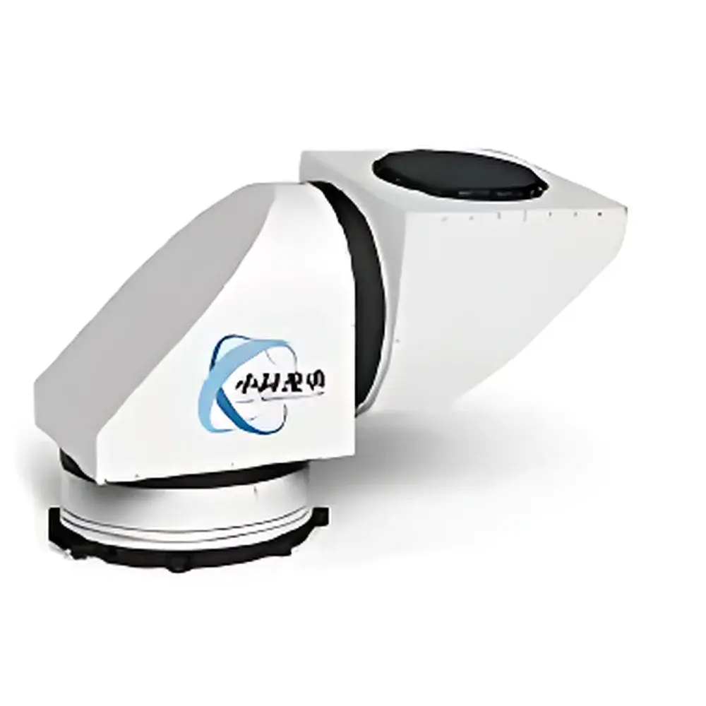
- Galvanometric scanning mirror system with integrated environmental protection—automated dust, moisture, and snow removal—enabling stable operation across temperature ranges from −25 °C to +50 °C and relative humidity up to 95% RH.
- Dual-polarization detection architecture using low-noise photomultiplier tubes (PMTs) optimized for 532 nm, supporting simultaneous acquisition of co-polarized and cross-polarized return signals for depolarization ratio calculation.
- GIS-integrated visualization engine for georeferenced 2D/3D mapping of aerosol concentration fields, facilitating source identification and plume trajectory modeling over complex terrain.
- Intelligent power management: automatic shutdown during grid failure and seamless restart upon power restoration, compliant with IEC 62040-3 for uninterruptible power system interoperability.
- Laser diode lifetime rated at ≥16,000 hours (MTBF), minimizing operational downtime and long-term maintenance costs.
Sample Compatibility & Compliance
The AGHJ-I-LIDAR(HPL) is designed for open-air atmospheric sampling without physical contact or sample collection. It meets the technical requirements specified in the Meteorological Specialized Technical Equipment Use Permit issued by the China Meteorological Administration (CMA). While not certified to EU CE or US EPA equivalency standards, its optical design and data processing algorithms align with internationally accepted lidar methodologies referenced in ISO 17123-8 (optoelectronic distance meters) and ASTM D6246 (standard guide for atmospheric aerosol measurements). The system supports audit-ready data logging with timestamped metadata, traceable to UTC via GPS-synchronized NTP, fulfilling baseline documentation needs for GLP-aligned environmental monitoring programs.
Software & Data Management
Control and analysis are performed through CASP’s proprietary LIDARView™ software suite, which includes real-time signal visualization, automated PBL height detection (using wavelet covariance transform), and batch inversion of aerosol extinction profiles using Fernald-Klett and Klett-Eloranta algorithms. Raw photon-counting data are stored in HDF5 format with embedded calibration coefficients, instrument status logs, and GPS coordinates. Export options include NetCDF-4, CSV, and GIS-compatible GeoTIFF layers. Software supports 21 CFR Part 11–compliant user access control, electronic signatures, and immutable audit trails for regulated applications. Remote diagnostics and firmware updates are enabled via TLS-secured HTTPS interface.
Applications
- Vertical Profiling: Continuous monitoring of aerosol vertical distribution up to 10 km AGL, supporting boundary layer dynamics studies and validation of numerical weather prediction (NWP) models.
- Point/Line Source Characterization: Targeted scanning of industrial stacks, power plant emissions, cement kilns, and major roadways to quantify emission fluxes and plume rise characteristics.
- Area-Wide Pollution Mapping: Quantitative assessment of aerosol loading across industrial parks, residential zones, and ecologically sensitive areas using raster-based scanning protocols.
- Mobile Campaign Monitoring: Vehicle-mounted operation in “park-and-scan” or directional transit mode for tracking regional pollution advection, frontal passage effects, and deposition patterns.
- Long-Term Trend Analysis: Integration into national air quality observation networks for multi-year trend evaluation aligned with WHO Air Quality Guidelines and national PM2.5/PM10 standards.
FAQ
What atmospheric parameters can this lidar directly measure?
It directly measures range-resolved elastic backscatter intensity at 532 nm for both parallel and perpendicular polarization channels. Derived products include aerosol extinction coefficient, depolarization ratio, PBL height, and AOD—calculated via established inversion algorithms.
Is the system suitable for outdoor deployment in harsh climates?
Yes. The galvo-scanner housing incorporates active environmental conditioning (heating, desiccant regeneration, and mechanical wiper-assisted snow removal), validated for continuous operation in desert, coastal, and sub-zero environments.
Does the system support integration with existing air quality monitoring networks?
Yes. It provides standardized API endpoints and SCADA-compatible Modbus TCP output for telemetry integration with central environmental data platforms (e.g., AQMesh, AirNow, or custom ETL pipelines).
What is the typical spatial resolution of vertical profiles?
Vertical resolution is configurable between 7.5 m and 30 m; temporal resolution ranges from 30 seconds (for PBL tracking) to 1 hour (for long-term trend analysis), depending on signal averaging settings.
Are calibration procedures traceable to international standards?
System calibration follows internal reference protocols traceable to NIST-traceable photometric standards; absolute calibration is performed annually using Rayleigh scattering cross-sections from molecular atmosphere models.
Related Products


