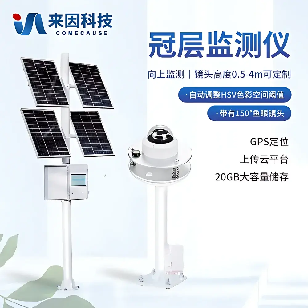

COMECAUSE IN-G100 Online Canopy Monitoring System
| Brand | COMECAUSE |
|---|---|
| Origin | Shandong, China |
| Manufacturer Type | Direct Manufacturer |
| Country of Origin | China |
| Model | IN-G100 |
| Price | USD 8,100 (FOB) |
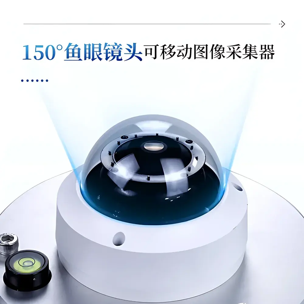
| Imaging Sensor | 150° fisheye lens (2592 × 1944 resolution) |
| PAR Spectral Range | 400–700 nm |
| PAR Measurement Range | 0–2000 µmol·m⁻²·s⁻¹ |
| Field Coverage Radius | 30 m |
| Lens Height Adjustment Range | 0.5–4 m (customizable) |
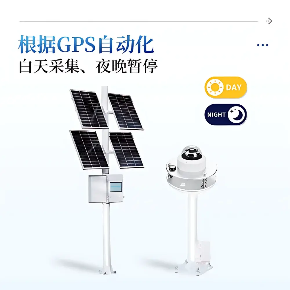
| Data Acquisition Interval | 0.5–72 h (user-configurable, daylight-activated via GPS) |
| Local Storage | 20 GB (≥180 days of image + metadata) |
| Power Supply | 200 W solar panel + 130 Ah gel battery (dual-mode: AC 220 V optional) |
| Operating Temperature | −10 °C to +55 °C |
| Display | 10-inch capacitive touchscreen (multi-language UI: English/Chinese) |
| Cloud Platform | Secure 4G-enabled agricultural data hub with audit-ready export (CSV, PNG, JSON) |
Overview
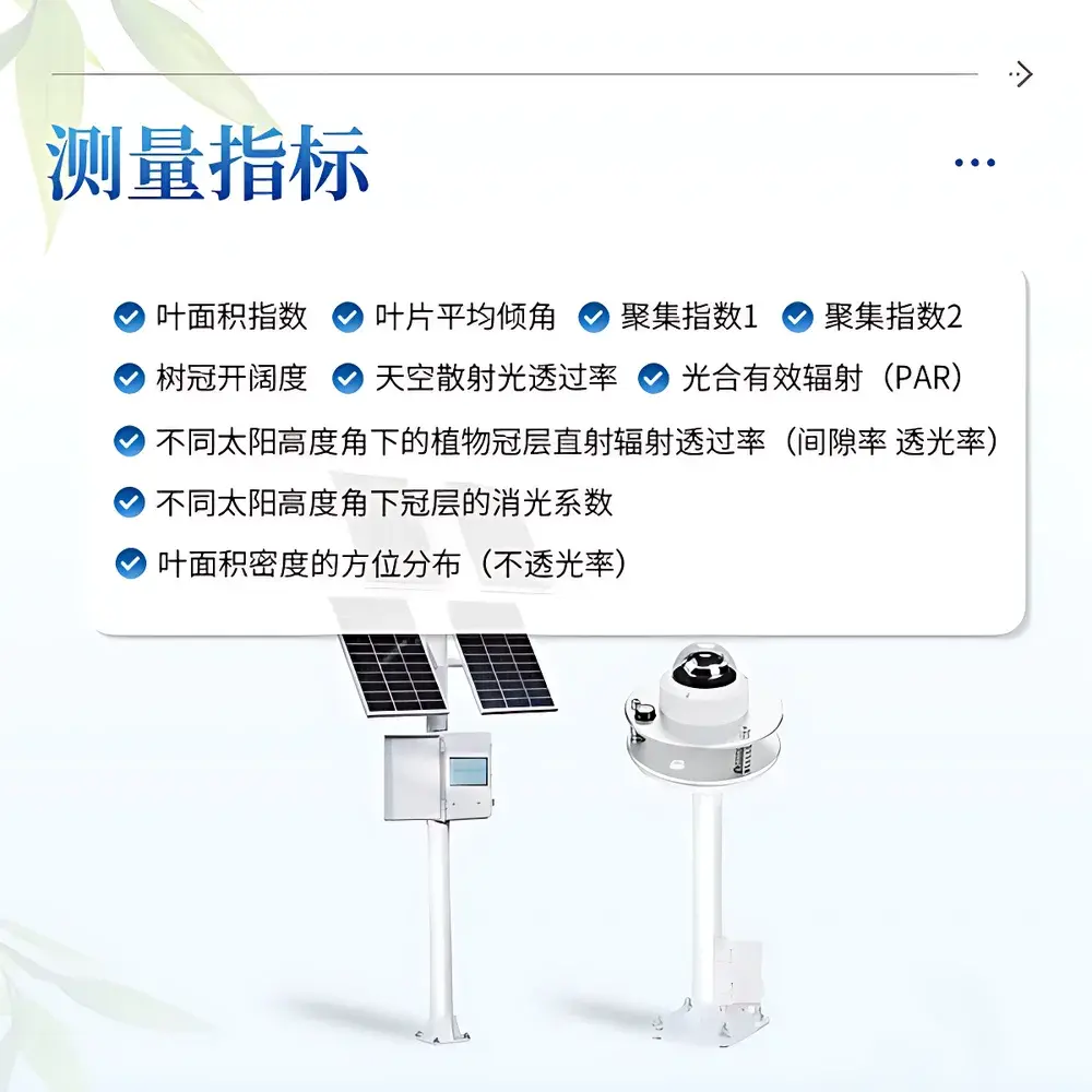
The COMECAUSE IN-G100 Online Canopy Monitoring System is a field-deployable, solar-powered instrumentation platform engineered for continuous, non-destructive assessment of plant canopy architecture and radiation interception dynamics. It operates on the widely validated fisheye photography principle—capturing upward-looking hemispherical images through a calibrated 150° wide-angle lens mounted beneath the canopy. These digital hemispheres are processed using geometrically constrained segmentation algorithms to quantify structural parameters including leaf area index (LAI), foliage inclination distribution, clumping indices (CI₁ and CI₂), canopy openness, and directional transmittance of photosynthetically active radiation (PAR, 400–700 nm). Unlike manual or handheld methods, the IN-G100 integrates autonomous diurnal scheduling, GPS-synchronized acquisition, and cloud-based analytics—enabling longitudinal studies of canopy development, phenological shifts, and microclimate modulation across agricultural, forestry, and ecological research sites.
Key Features
- Fully autonomous operation: GPS-triggered daytime imaging with nighttime suspension; configurable acquisition intervals from 30 minutes to 72 hours
- High-fidelity optical capture: 150° fisheye lens (2592 × 1944 resolution) with zenithal (0°–75°) and azimuthal (0°–360°) 10-zone discretization for spatially resolved gap fraction analysis
- Integrated PAR sensing: Cosine-corrected quantum sensor compliant with ISO 17166:2021 (CIE S 025/E:2015) spectral response, enabling concurrent measurement of direct beam and diffuse sky radiation transmittance at variable solar elevation angles
- Onboard image processing: Embedded Linux-based analysis engine performing real-time HSV color space thresholding, shadow correction, and pixel-based gap classification—minimizing operator bias and ensuring inter-site reproducibility
- Dual-power resilience: 200 W monocrystalline solar array paired with 130 Ah maintenance-free gel battery; AC 220 V fallback option for grid-connected deployments
- Robust environmental rating: IP65-rated enclosure; operational stability across −10 °C to +55 °C ambient temperatures and high-humidity field conditions
Sample Compatibility & Compliance
The IN-G100 is compatible with herbaceous and woody vegetation canopies up to 4 m in height, supporting both row-crop (e.g., maize, soybean, cotton) and orchard/forest understory configurations. Its fisheye-based methodology aligns with established protocols in ISO 11727:2020 (optical determination of LAI), ASTM E2913-22 (standard guide for canopy light interception measurements), and FAO CropWat modeling requirements. All firmware and cloud data handling comply with GLP-aligned metadata tagging—including timestamp (UTC), GPS coordinates (WGS84), solar geometry (zenith/azimuth), and instrument calibration status. Audit trails for data uploads, user logins, and parameter modifications meet baseline traceability expectations under FDA 21 CFR Part 11 Annex 11 principles.
Software & Data Management
Data acquisition, preprocessing, and visualization occur via the COMECAUSE AgriCloud Platform—a secure, role-based web interface accessible via desktop or mobile browsers. Raw fisheye images, processed canopy metrics, and time-series PAR logs are stored with SHA-256 checksum validation. Users may export structured datasets in CSV (for statistical analysis in R/Python/MATLAB), annotated PNGs (for publication), or JSON (for API integration with farm management software such as Climate FieldView or Granular). The system supports automated alerts (email/SMS) for anomalies—e.g., sustained low PAR transmission indicating pest infestation or canopy closure exceeding agronomic thresholds. All cloud interactions employ TLS 1.3 encryption and OAuth 2.0 authentication.
Applications
- Long-term canopy phenology tracking in breeding trials (e.g., LAI progression curves for drought-tolerant wheat lines)
- Irrigation scheduling support via real-time PAR attenuation monitoring and canopy conductance estimation
- Forest regeneration assessment: quantifying understory light availability and gap-phase dynamics in mixed-species stands
- Urban green infrastructure evaluation: measuring seasonal shading efficacy of street tree canopies on pedestrian thermal comfort
- Validation of radiative transfer models (e.g., SAIL, 4SAIL) using ground-truthed gap fraction profiles across azimuth/zenith bins
- Carbon sequestration modeling input: LAI and clumping index data integrated into eddy covariance flux partitioning workflows
FAQ
Does the IN-G100 require manual image calibration before each deployment?
No. The system performs automatic white-balance and HSV threshold adaptation during each acquisition cycle using reference patches embedded in the fisheye dome’s periphery.
Can raw fisheye images be exported for third-party analysis?
Yes. All original TIFF-format hemispherical images are retained locally and downloadable via USB 3.0 or cloud API with full EXIF metadata (GPS, UTC timestamp, lens distortion coefficients).
Is the cloud platform compatible with existing GIS or ERP systems?
Yes. RESTful API endpoints support standardized OGC SensorThings API v1.1 payloads, enabling seamless ingestion into QGIS, ArcGIS Enterprise, or SAP S/4HANA Agriculture modules.
What is the typical battery autonomy during extended cloudy periods?
Under worst-case conditions (72 h continuous overcast), the 130 Ah battery sustains >14 days of scheduled operation at 2-hour intervals—verified per IEC 62133-2:2017 discharge testing.
How is data integrity ensured during intermittent 4G connectivity?
Local storage buffers all untransmitted data with CRC32 error checking; retransmission resumes automatically upon network restoration, with sequence-numbered packet reconciliation.
Related Products