COMECAUSE IN-G20 Portable Canopy Analyzer for Leaf Area Index (LAI) and Structural Parameter Measurement
| Brand | COMECAUSE |
|---|---|
| Origin | Shandong, China |
| Manufacturer Type | Direct Manufacturer |
| Model | IN-G20 |
| Principle | Hemispherical Digital Image Analysis |
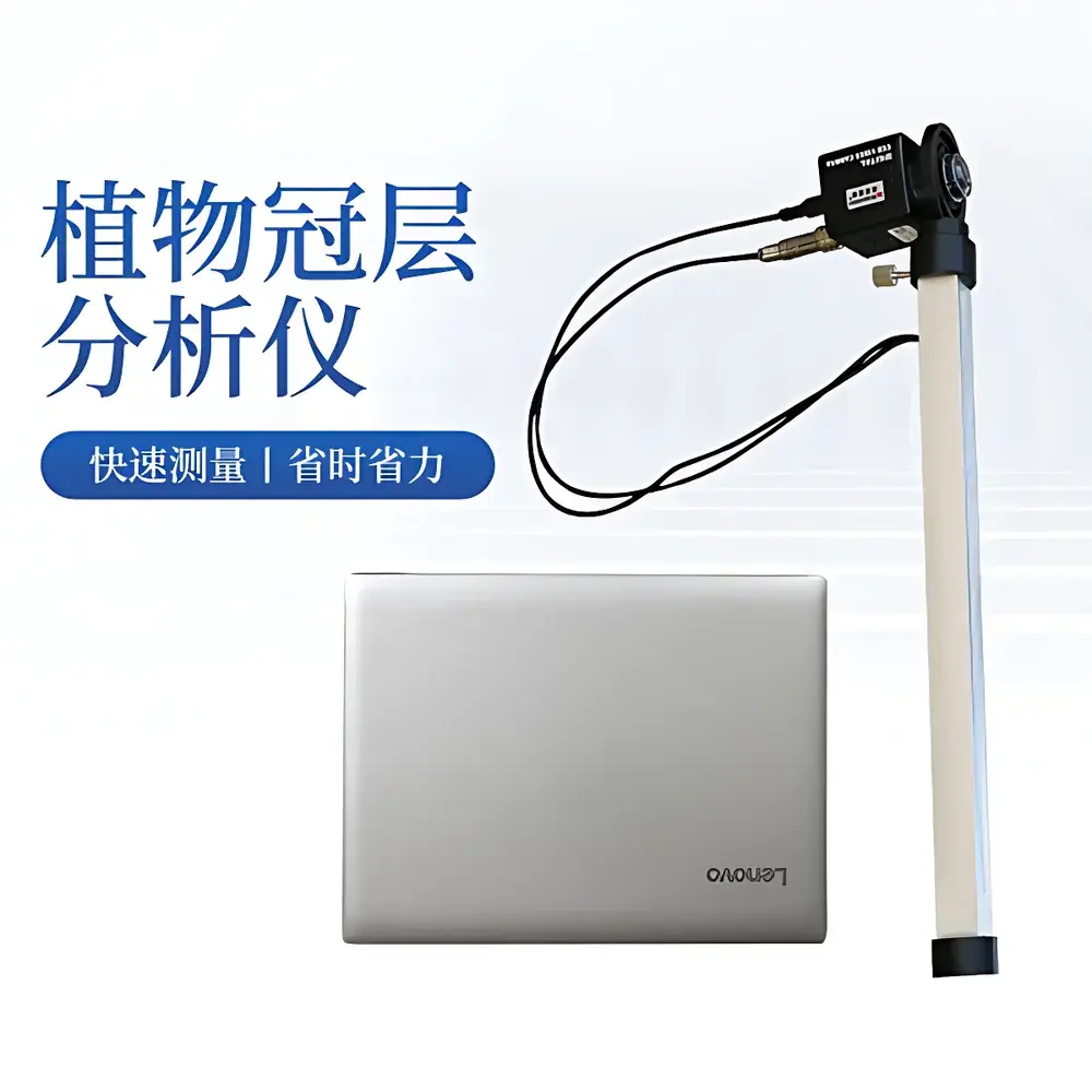
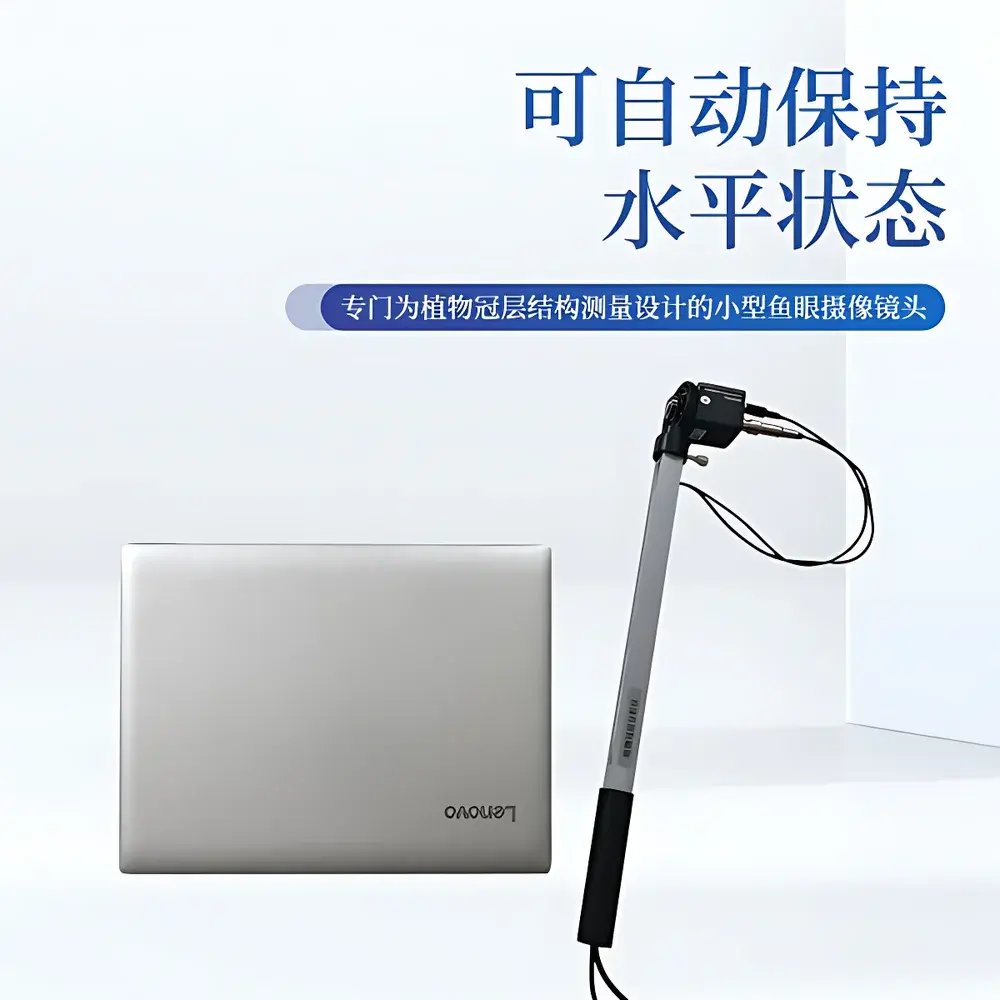
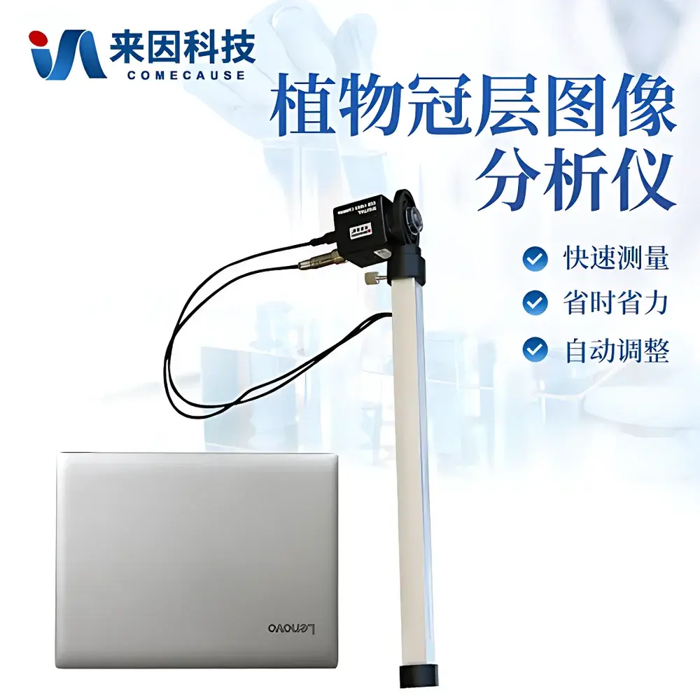
| Form Factor | Handheld Portable System |
| PAR Sensor Range | 400–700 nm |
| Photosynthetic Photon Flux Density (PPFD) Measurement Range | 0–2000 μmol·m⁻²·s⁻¹ |
| Field of View | 150° Fisheye Lens |
| Image Resolution | 768 × 494 pixels |
| Zenith Angle Coverage | 0°–75° (divisible into 10 zones) |
| Azimuthal Coverage | 0°–360° (divisible into 10 zones) |
| Operating Temperature | 0–55 °C |
| Probe Dimensions | Ø60 mm × 100 mm |
| Weight (probe only) | 500 g |
| Interface | USB 2.0 |
| GPS Integration | Built-in geotagging with real-time latitude/longitude output |
| Data Cloud Sync | Encrypted upload to proprietary agricultural cloud platform |
Overview
The COMECAUSE IN-G20 Portable Canopy Analyzer is an engineered field instrument designed for non-destructive, rapid quantification of plant canopy structural parameters using hemispherical digital image analysis. It operates on the physical basis of radiation transmission through vegetation canopies—specifically applying the Beer–Lambert law under standardized assumptions of leaf angle distribution and light scattering behavior. By capturing fisheye-lens-based hemispherical images of the sky above and beneath the canopy, the system computes key biophysical indices including Leaf Area Index (LAI), gap fraction, foliage inclination angle distribution, extinction coefficient, and directional transmittance at varying solar zenith angles. Unlike destructive sampling or point-sensor methods, the IN-G20 delivers spatially resolved, repeatable metrics across heterogeneous stands without altering canopy integrity—making it suitable for longitudinal ecological monitoring, agronomic trials, and forest inventory applications.
Key Features
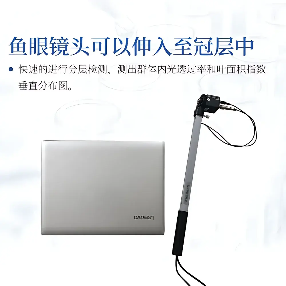
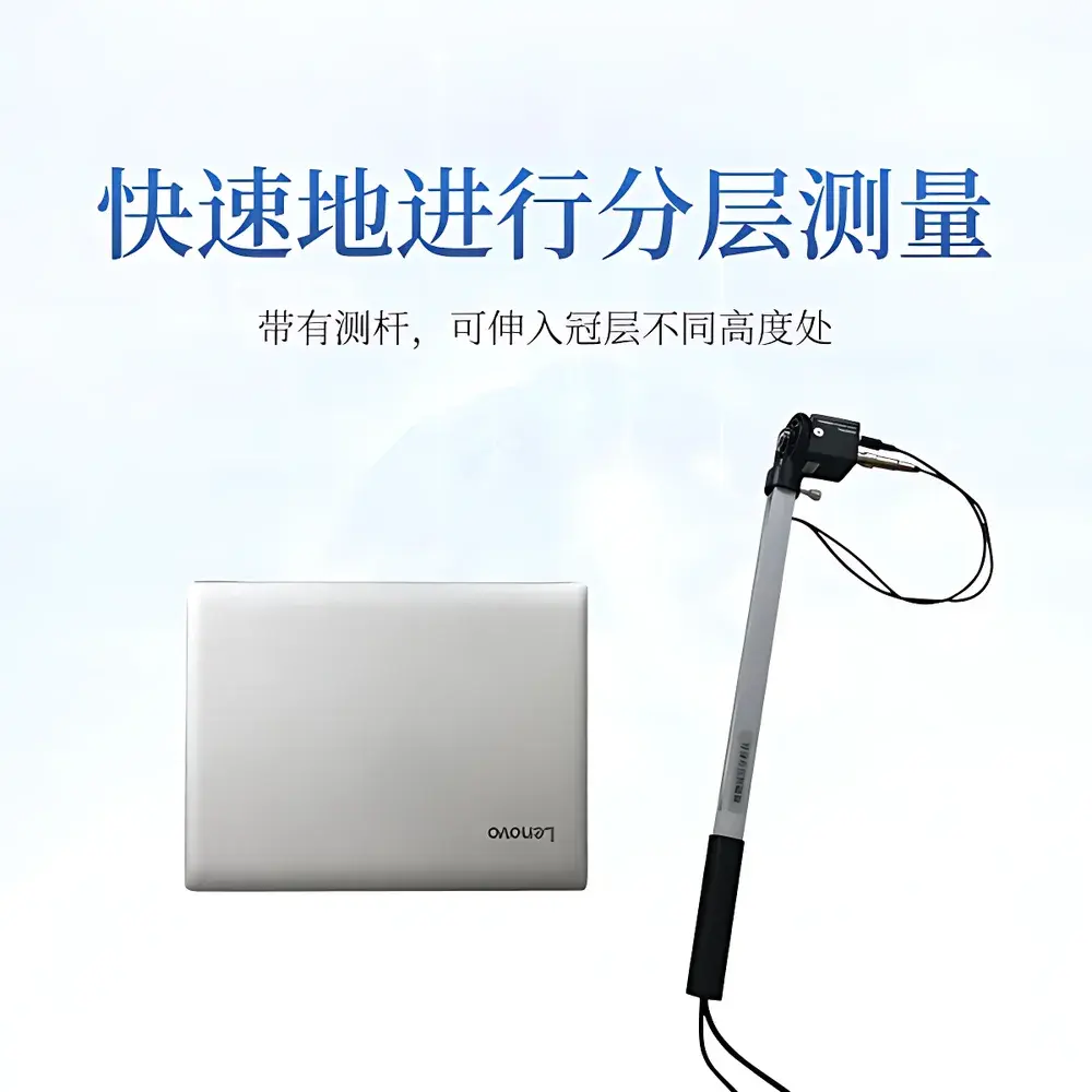
- Fisheye optical probe with 150° field-of-view lens and automatic leveling gimbal mount—enabling stable, orientation-independent image capture without tripods.
- Integrated 25-channel PAR sensor array mounted along a telescoping measurement rod—providing concurrent photosynthetic photon flux density (PPFD) validation alongside image-derived structural metrics.
- High-fidelity CCD imaging sensor (768 × 494 resolution) optimized for visible spectrum (400–700 nm) with calibrated dynamic range up to 2000 μmol·m⁻²·s⁻¹ PPFD.
- Zenith-azimuthal zoning capability: user-definable partitioning of the hemispherical image into up to 10 zenith-angle bands and 10 azimuth sectors—supporting stratified analysis of vertical and horizontal canopy heterogeneity.
- Region-of-interest masking functionality: allows exclusion of non-canopy artifacts (e.g., gaps due to missing plants, edge effects, or obstructions) during threshold-based segmentation.
- Real-time GPS geotagging with embedded NMEA output—ensuring traceable spatial metadata for GIS integration and time-series site-level comparisons.
- USB 2.0 interface with plug-and-play compatibility to Windows-based laptops; includes hardware encryption dongle for software licensing and data security compliance.
Sample Compatibility & Compliance
The IN-G20 is validated for use across diverse vegetation types—including row crops (maize, soybean, wheat), orchard systems, shrublands, and closed-canopy forests—provided the target canopy height permits probe insertion at multiple vertical positions. Its optical design accommodates variable leaf optical properties (e.g., reflectance, transmittance) without requiring species-specific calibration. The system conforms to internationally accepted protocols for LAI estimation as defined in ISO 11727:2022 (Optics and photonics — Instruments for measuring leaf area index) and aligns with methodological frameworks cited in USDA ARS Technical Bulletin No. 1934 and FAO CropWat guidelines. All software modules support audit-trail logging and user-access controls compatible with GLP-aligned workflows; raw image files and processed outputs are stored in open TIFF and CSV formats to ensure long-term reproducibility and third-party validation.
Software & Data Management
The bundled CanopyStruct Analyze Suite (v4.2+) provides full workflow control—from image acquisition and geometric correction to multi-threshold segmentation and radiative transfer modeling. The software implements both classic gap-fraction inversion (based on the Lang–Sartori model) and optional two-stream approximations for improved accuracy under clumped canopies. All analyses generate exportable reports compliant with MIAME and ISA-TAB metadata standards. Processed datasets synchronize automatically via TLS 1.2–secured HTTPS to the COMECAUSE AgriCloud platform, where users access role-based dashboards, temporal trend visualizations, and API endpoints for integration with farm management information systems (FMIS) or research LIMS. Local data storage adheres to GDPR and HIPAA-aligned encryption standards; no telemetry or usage analytics are transmitted without explicit opt-in consent.
Applications
- Agronomic Monitoring: Enables high-frequency LAI tracking during critical phenophases (e.g., vegetative growth, tasseling, grain fill), supporting nitrogen-use efficiency modeling and irrigation scheduling based on actual canopy light interception dynamics.
- Ecological Field Studies: Supports long-term monitoring of successional change, disturbance recovery, and climate-driven phenological shifts—particularly valuable in NEON, LTER, and ILTER network protocols.
- Forestry Inventory: Facilitates rapid estimation of basal area, crown closure, and understory light availability—complementing LiDAR-derived metrics in mixed-species stands where laser penetration is limited.
- Urban Green Infrastructure Assessment: Quantifies shading efficacy and evapotranspirative potential of street trees and green roofs through spatially explicit transmittance mapping.
- Educational Use: Serves as a pedagogical tool for teaching micrometeorology, plant–light interactions, and remote sensing fundamentals in undergraduate and graduate curricula.
FAQ
Does the IN-G20 require external power sources in the field?
No—the fisheye probe and PAR rod operate via USB bus power from the connected laptop; no batteries or AC adapters are needed during standard operation.
Can the system be used under cloudy or low-light conditions?
Yes—the CCD sensor and PAR array maintain calibrated linearity down to 5 μmol·m⁻²·s⁻¹, enabling reliable measurements under diffuse skylight and overcast conditions.
Is the software compatible with macOS or Linux operating systems?
The CanopyStruct Analyze Suite is Windows-native (Windows 10/11, 64-bit); however, virtualized execution via Parallels Desktop or VMware Workstation is supported for macOS users.
How does the IN-G20 handle overlapping or highly clumped foliage?
The software includes a clumping correction module based on the Beta function approximation, allowing users to input stand-level effective LAI estimates derived from allometric relationships or independent measurements.
What level of technical support and firmware updates are provided post-purchase?
COMECAUSE offers 3 years of complimentary remote diagnostics, software patches, and annual calibration verification services; extended service contracts include on-site technician deployment within APAC regions.