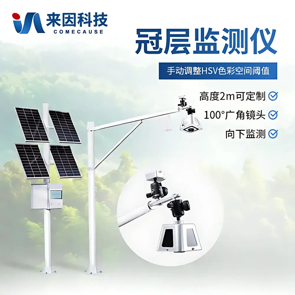
COMECAUSE IN-G200 Wireless Canopy Analyzer
| Brand | COMECAUSE |
|---|---|
| Origin | Shandong, China |
| Manufacturer Type | Direct Manufacturer |
| Model | IN-G200 |
| Measurement Principle | Hemispherical Photography-Based Canopy Structure Analysis |
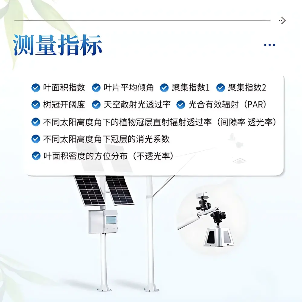
| PAR Sensor Range | 0–2000 μmol·m⁻²·s⁻¹ (400–700 nm) |
| Image Resolution | 2592 × 1944 |
| Field of View | 100° (Zenith Angle: 0°–75°, Azimuth: 0°–360°, both subdivided into 10 sectors) |
| Data Storage | 20 GB local (≥180 days of image + metadata) |
| Transmission | 4G LTE to cloud platform |
| Power Supply | 200 W solar panel + 130 Ah gel battery (or optional 220 V AC) |
| Operating Temperature | −10 °C to +55 °C |
| Deployment Radius | Up to 30 m from host unit |
| Minimum Sampling Interval | 1 hour |
| Display | 10-inch color touchscreen with HSV threshold calibration |
| Supported Languages | English, Simplified Chinese |
Overview
The COMECAUSE IN-G200 Wireless Canopy Analyzer is a field-deployable, solar-powered instrument engineered for long-term, unattended monitoring of plant canopy architecture and radiation interception dynamics. It operates on the internationally standardized principle of hemispherical photography—capturing downward-facing fisheye images of the canopy from above, followed by automated digital analysis of gap fraction, pixel classification, and angular distribution of sky visibility. This method provides quantitative, non-destructive estimates of structural parameters that govern light capture, photosynthetic efficiency, and microclimate regulation within crop stands. Unlike manual or handheld canopy meters requiring repeated site visits, the IN-G200 enables continuous, time-synchronized observation across full phenological cycles—from emergence through senescence—delivering high-temporal-resolution datasets essential for physiological modeling, irrigation scheduling, and precision agronomic intervention.
Key Features
- Solar-reliant autonomous operation with integrated 200 W photovoltaic panel and 130 Ah deep-cycle gel battery, enabling multi-season deployment without grid access.
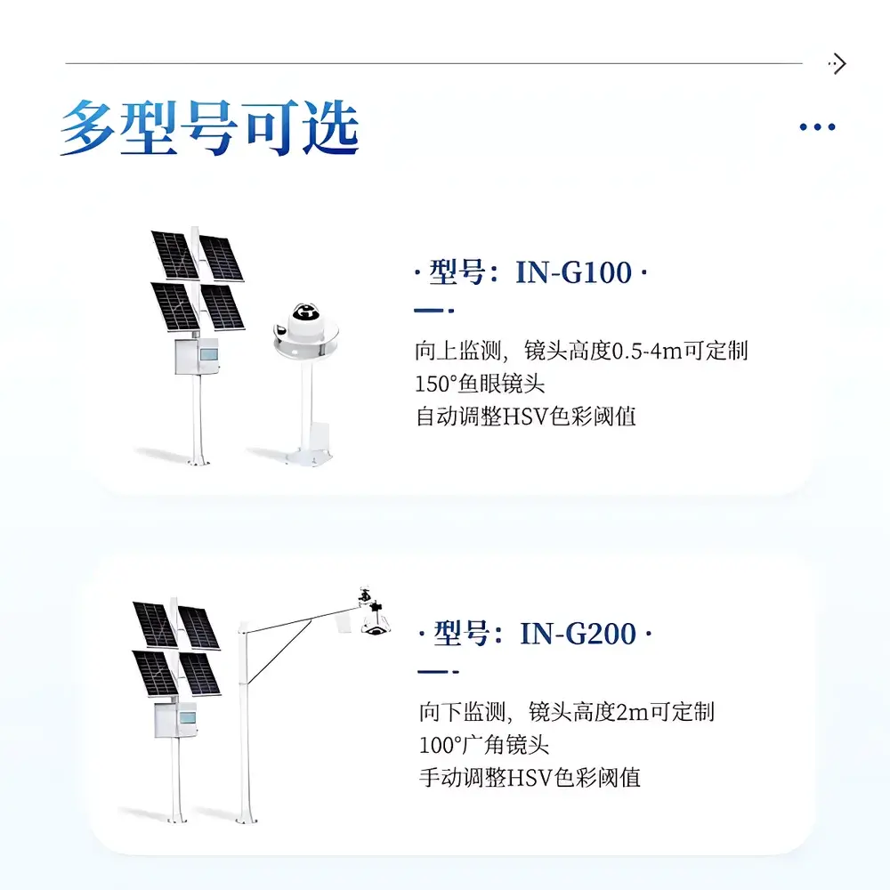
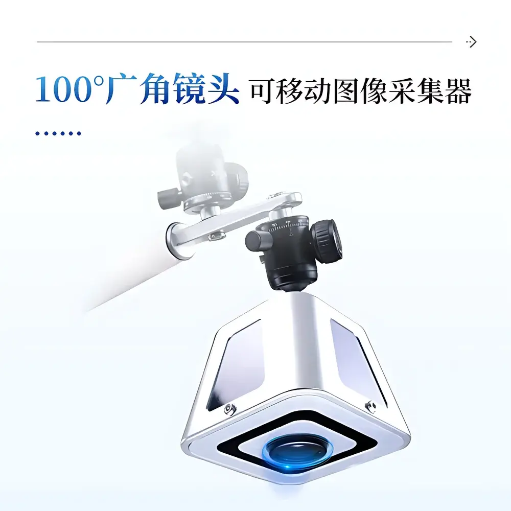
- Motorized, pan-tilt-capable imaging head equipped with a calibrated 100° wide-angle lens (f/2.0), positioned at 2 m height (customizable) above canopy level for consistent geometric sampling.
- Full-spectrum PAR sensor (400–700 nm) co-located with imaging head, synchronized to record incident and transmitted photosynthetically active radiation under varying solar zenith angles.
- Onboard image processing engine performing real-time segmentation using HSV color space thresholding, configurable via 10-inch touchscreen interface supporting English and Simplified Chinese.
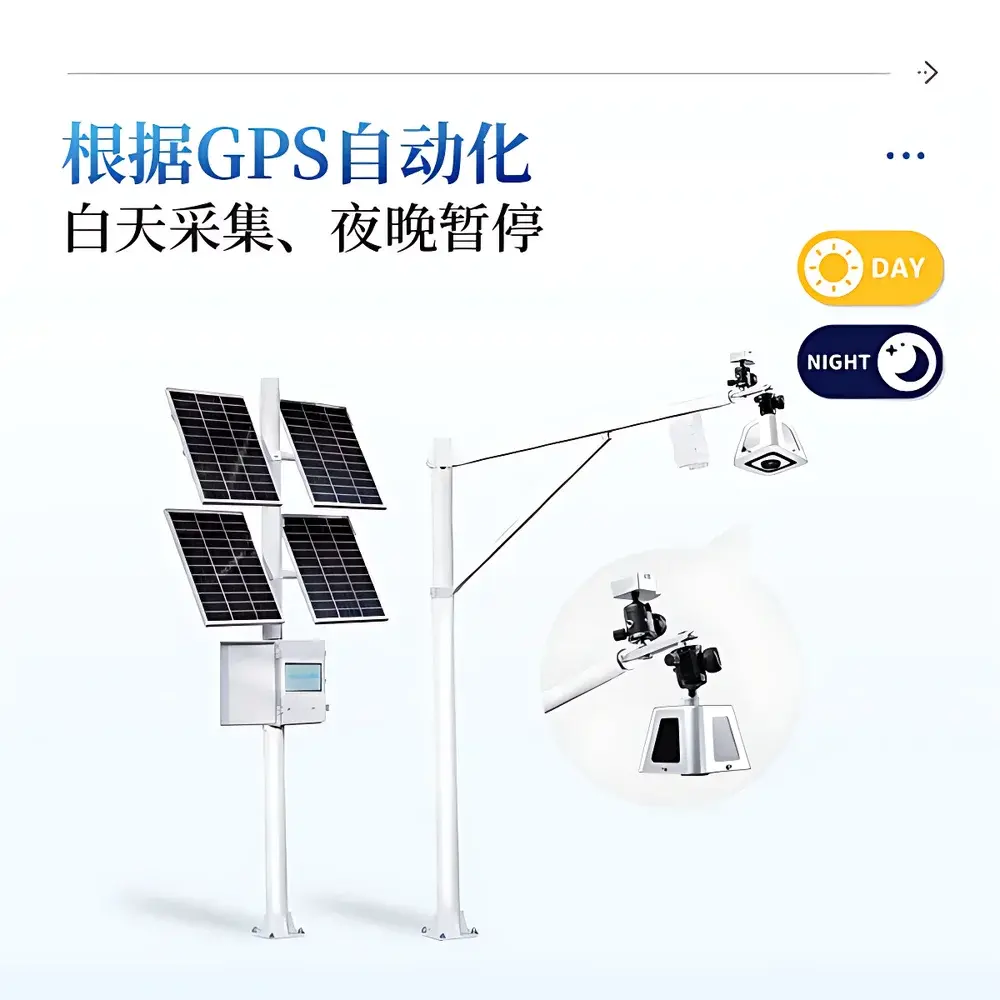
- GPS-synchronized acquisition logic: automatic daytime-only image capture triggered by solar elevation; nighttime suspension prevents unnecessary power consumption and thermal noise accumulation.
- Robust environmental enclosure rated IP67, validated for continuous operation between −10 °C and +55 °C in open-field agricultural environments.
Sample Compatibility & Compliance
The IN-G200 is compatible with herbaceous and semi-woody vegetation including cereal crops (wheat, rice, maize), row crops (soybean, cotton), horticultural species (tomato, strawberry), and perennial systems (vineyards, orchards). Its measurement protocol aligns with ISO 11727:2022 (optical methods for leaf area index estimation) and ASTM E2913-21 (standard practice for determining canopy light transmission). Data integrity conforms to GLP-aligned audit trails: each image and PAR reading is timestamped, geotagged, and annotated with sensor status flags. While not FDA 21 CFR Part 11-certified out-of-the-box, the cloud platform supports user-defined electronic signature workflows and export formats compliant with FAO AgroDataCube and Crop Ontology standards.
Software & Data Management
Raw images and radiometric data are processed onboard and stored locally (20 GB NAND flash) before secure 4G LTE transmission to the COMECAUSE AgriCloud platform. Users access time-series visualizations—including LAI trajectories, zenith-angle-resolved transmittance curves, azimuthal light distribution heatmaps, and PAR attenuation profiles—via browser-based dashboards. All datasets support CSV/NetCDF export with embedded metadata (EXIF + custom schema). The platform enforces role-based access control and integrates with third-party farm management software (e.g., Climate FieldView, Granular) via RESTful API. Local USB-C export allows offline validation and reproducible analysis using open-source tools such as R ‘raster’ and Python ‘scikit-image’.
Applications
- Dynamic LAI Monitoring: Tracking leaf area expansion and decline across growth stages to detect nitrogen deficiency, water stress, or pest-induced premature senescence.
- Radiation Use Efficiency (RUE) Modeling: Coupling PAR transmission profiles with biomass accumulation data to calibrate process-based crop models (e.g., APSIM, DSSAT).
- Irrigation Decision Support: Deriving real-time crop coefficients (Kc) from observed canopy closure and PAR interception, feeding into evapotranspiration-driven irrigation controllers.
- Planting Geometry Optimization: Quantifying how row orientation, spacing, and cultivar architecture affect diurnal light penetration—informing varietal selection and planting prescription maps.
- Agricultural Insurance & Yield Forecasting: Providing objective, auditable canopy development metrics for parametric insurance triggers and pre-harvest yield estimation frameworks.
FAQ
What is the minimum recommended deployment height for the imaging head?
The standard configuration assumes a 2 m mounting height above ground level, optimized for typical cereal and row-crop canopies. Custom heights from 1.5 m to 4 m are supported upon request.
Can the system operate in low-light or overcast conditions?
Yes—the PAR sensor maintains linearity down to 5 μmol·m⁻²·s⁻¹, and image analysis relies on contrast-based segmentation rather than absolute brightness, ensuring robustness under diffuse illumination.
How frequently can data be uploaded to the cloud?
Transmission intervals are user-configurable from 1 hour to 72 hours; uploads occur only after successful onboard processing and battery voltage verification.
Is raw image data accessible for independent analysis?
Yes—full-resolution TIFF images (2592 × 1944) and associated EXIF metadata (including GPS, timestamp, exposure settings) are retained locally and exportable via USB-C.
Does the system require annual recalibration?
The PAR sensor is factory-calibrated traceable to NIST standards; no routine recalibration is required. Lens vignetting and color response are corrected during initial setup using included calibration targets.
Related Products