COMECAUSE IN-GD10 Portable Vegetation Canopy Cover Analyzer
| Brand | COMECAUSE |
|---|---|
| Origin | Shandong, China |
| Manufacturer | Yes |
| Country of Origin | China |
| Model | IN-GD10 |
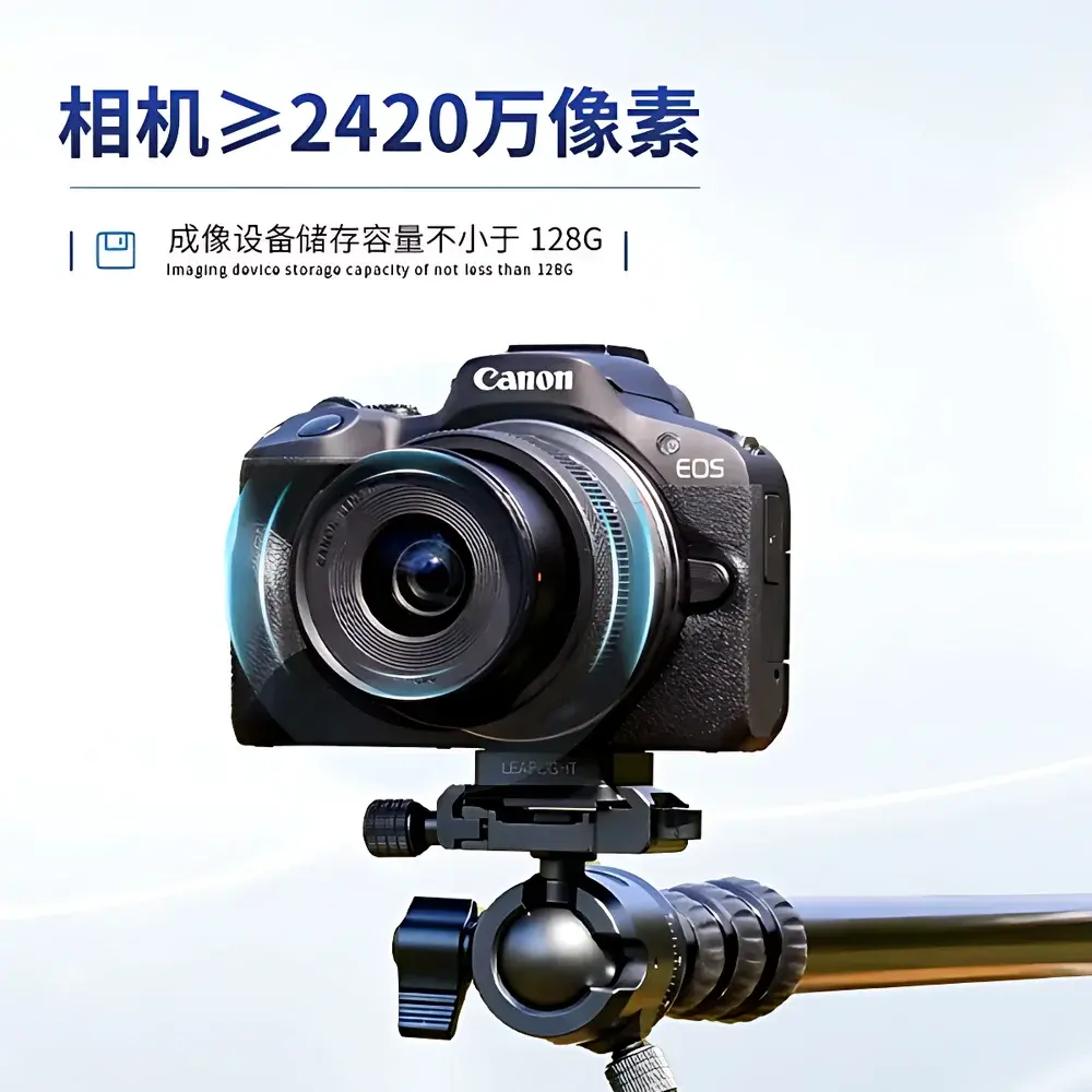
| Imaging Sensor | ≥24.2 MP CMOS |
| Storage Capacity | ≥128 GB internal |
| Optical Zoom | 18–45 mm f/3.5–6.3 |
| Focus | Auto-focus with exposure & flash compensation |
| Image Formats | JPEG, PNG, BMP |
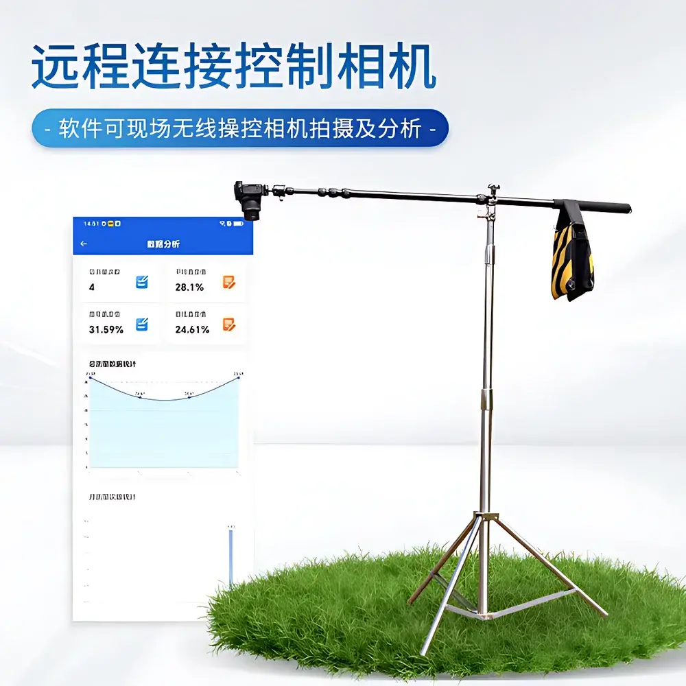
| Connectivity | Wi-Fi hotspot (10 m range), wireless remote camera control |
| Operating Temperature | −25 °C to +55 °C |
| Relative Humidity | ≤80% RH |
| Software Platform | Android 6.0+ |
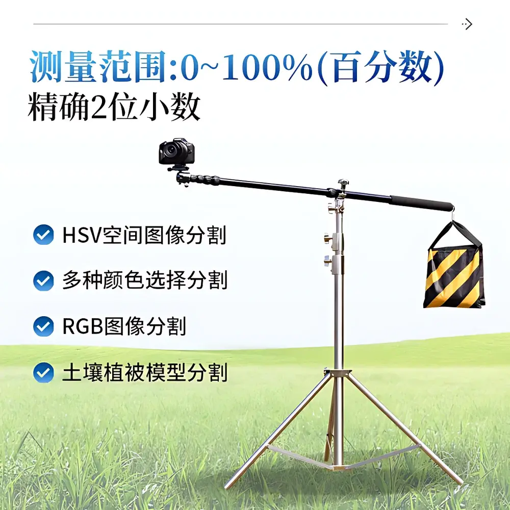
| Coverage Range | 0–100% (two-decimal precision) |
| Accuracy | ≥90% (field validation), ≥95% (binary output consistency) |
| Segmentation Modes | HSV, RGB, multi-color selection, soil-vegetation spectral model |
| Max Input Image Size | ≥50 MB |
| Data Export | Geo-tagged analysis reports, Excel (.xlsx), binary masks, annotated images |
| Cloud Sync | Yes (encrypted HTTPS upload with geolocation metadata) |
Overview
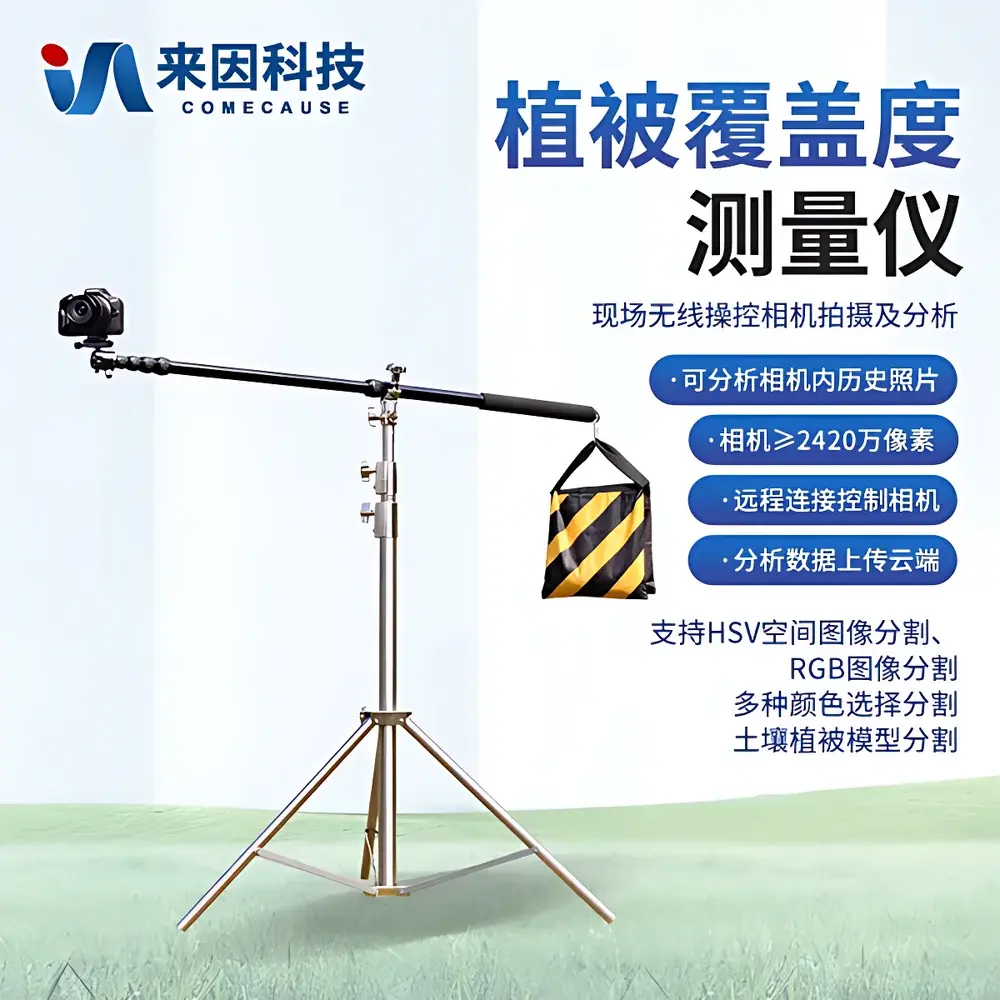
The COMECAUSE IN-GD10 Portable Vegetation Canopy Cover Analyzer is a field-deployable digital imaging system engineered for quantitative, non-destructive assessment of vegetation canopy cover and closure—key biophysical parameters in ecological monitoring, agricultural land management, rangeland health evaluation, and climate change impact studies. Unlike manual ocular estimation or point-intercept methods, the IN-GD10 employs computer vision–based image segmentation calibrated to spectral reflectance characteristics of green vegetation and bare soil substrates. It operates on the principle of pixel-level classification within standardized color spaces (RGB and HSV), augmented by an embedded soil-vegetation spectral response model trained across diverse biome types—including temperate grasslands, arid shrublands, paddy fields, and Mediterranean scrub. The system integrates a high-resolution interchangeable-lens DSLR (Canon EOS R50) with proprietary Android-based analytical software, enabling real-time acquisition, georeferenced processing, and reproducible quantification without destructive sampling or laboratory dependency.
Key Features
- Field-rugged optical platform: Canon EOS R50 camera with 24.2 MP APS-C CMOS sensor, 18–45 mm zoom lens, auto-focus, auto-exposure, and flash compensation optimized for variable ambient light conditions.
- Dual-color-space segmentation engine: Supports HSV-based hue-saturation-value thresholding and RGB channel-specific intensity masking—both configurable manually or via automated adaptive algorithms.
- Soil-vegetation spectral model: Pre-trained classification module accounting for regional variations in soil tone, litter cover, shadow effects, and senescent biomass, improving robustness across heterogeneous landscapes.
- Geo-referenced data capture: Integrated GPS tagging (via paired Android device) embeds latitude, longitude, altitude, and timestamp into every processed image and report.
- High-capacity local processing: On-device analysis of images up to 50 MB; ≥128 GB onboard storage ensures extended field deployment without external media.
- Wireless operational flexibility: Built-in Wi-Fi hotspot enables direct connection to Android tablets or smartphones at distances up to 10 meters—fully functional in offline environments (e.g., remote pastures, forest understory).
- Remote camera control: Real-time shutter triggering, live view preview, and batch capture scheduling via mobile app interface.
Sample Compatibility & Compliance
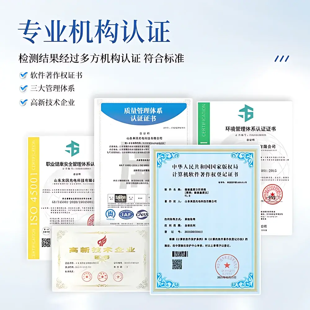
The IN-GD10 is designed for open-field, canopy-level imaging of herbaceous and low-stature woody vegetation—suitable for crops (e.g., wheat, maize, soybean), grasslands, alpine meadows, coastal dunes, and post-fire succession plots. It does not require physical contact with plant tissue and imposes no disturbance to growth dynamics. While not certified to ISO/IEC 17025 or ASTM E2923 (as it is a field-imaging tool rather than a metrological instrument), its analytical outputs align with widely accepted protocols including USDA-NRCS Field Handbook Chapter 4 (Canopy Cover Estimation), FAO’s Global Land Cover Monitoring guidelines, and the European Union’s Copernicus Land Monitoring Service validation frameworks. All geotagged output files comply with EXIF 2.3 and XMP metadata standards, supporting traceability in GLP-aligned environmental reporting.
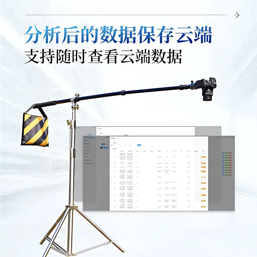
Software & Data Management
The Android application (v3.2+, compatible with Android 6.0 and later) provides a full-featured image analytics workflow: cropping, rotation, zoom, contrast enhancement, and multi-layer mask editing. Users may select single-image or batch-mode analysis; results include canopy cover (%) and closure (%), binary masks (black/white), false-color overlays, and statistical summaries (mean, min, max, SD). Output formats include PNG/JPEG/BMP for visualization and structured .xlsx exports containing measurement metadata, tolerance settings, RGB/HSV thresholds used, geographic coordinates, and timestamps. All datasets support encrypted cloud upload via TLS 1.2–secured endpoints; cloud-stored records retain full audit trails, including user ID, upload time, and modification history—facilitating compliance with FAIR data principles and internal QA/QC review cycles.
Applications
- Agricultural extension services: Rapid assessment of crop establishment uniformity, intercropping density, and residue cover pre-planting.
- Rangeland monitoring programs: Annual tracking of perennial grass cover, invasive species encroachment, and drought-induced dieback.
- Ecological restoration projects: Quantitative baseline and post-intervention evaluation of native seedling survival and ground-layer re-establishment.
- Carbon sequestration verification: Supporting Tier 2 IPCC inventory calculations where canopy cover serves as a proxy for aboveground biomass accumulation.
- University field ecology courses: Teaching objective vegetation structure quantification with immediate visual feedback and exportable datasets for statistical analysis.
- Government land-use audits: Generating defensible, repeatable metrics for compliance with national soil conservation policies (e.g., China’s Grassland Law, US Farm Bill Conservation Reserve Program).
FAQ
Does the IN-GD10 require internet connectivity to function in the field?
No. The device creates its own Wi-Fi hotspot, enabling local communication between the camera and Android host without cellular or external network infrastructure.
Can the software process drone-captured imagery?
Yes—provided images meet resolution and lighting criteria (≥24 MP, minimal motion blur, consistent illumination), and are saved in JPEG/PNG/BMP format with embedded EXIF metadata.
Is calibration required before each measurement session?
No routine hardware calibration is needed. However, users are advised to capture a reference image under representative lighting conditions when transitioning between markedly different environments (e.g., shaded forest floor to open steppe) to refine HSV/RGB thresholds.
How is measurement accuracy validated?
Accuracy ≥90% refers to agreement with ground-truth ocular estimates performed by trained ecologists across >200 independent test sites spanning six vegetation types; ≥95% reflects intra-software repeatability under identical input parameters.
Are software updates provided after purchase?
Yes—COMECAUSE delivers free over-the-air (OTA) firmware and Android app updates for two years post-purchase, including new segmentation models, enhanced geotagging fidelity, and expanded Excel export templates.


