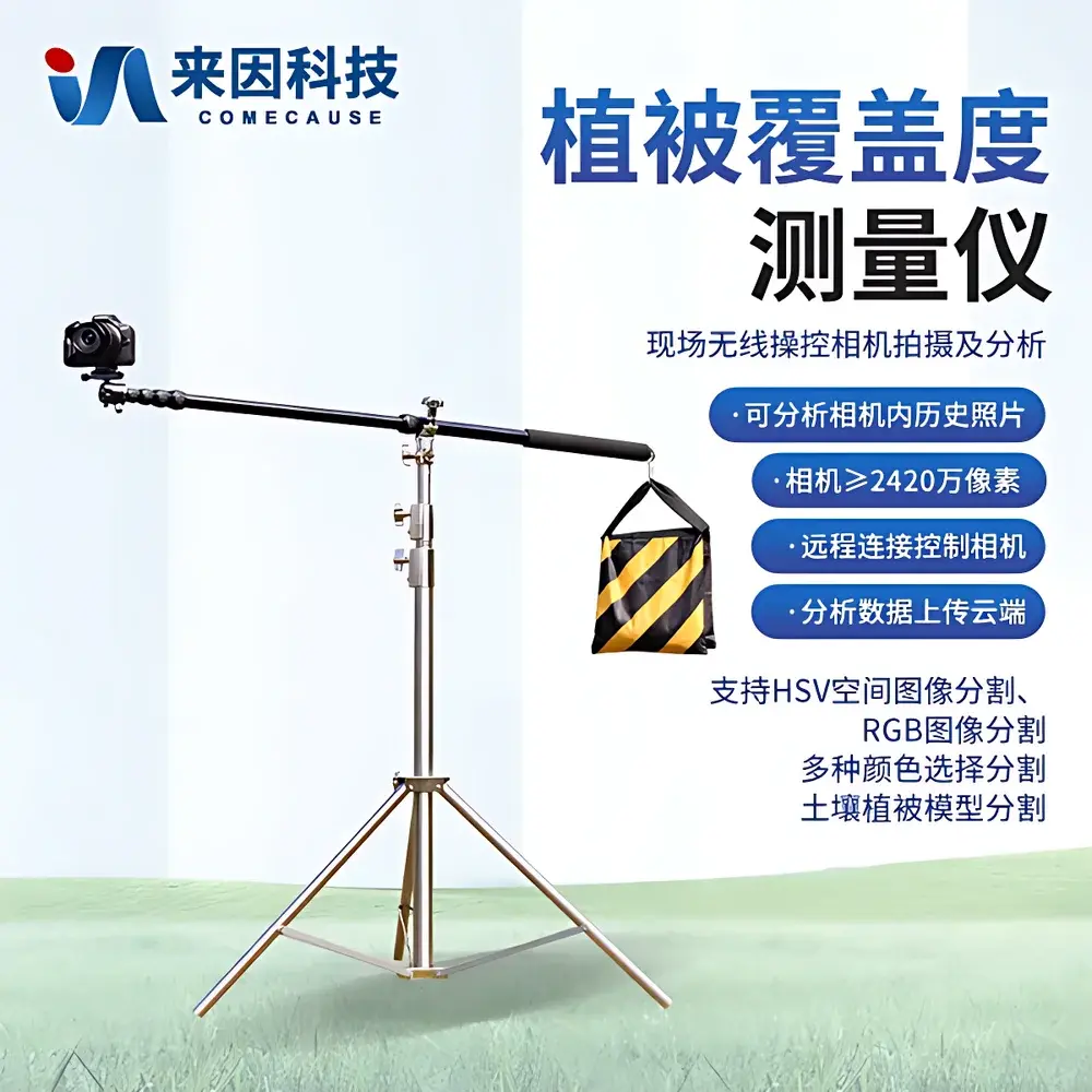
COMECAUSE IN-GD10 Vegetation Cover Analyzer – Portable Canopy Coverage & Canopy Closure Measurement System
| Key Features | Android-based image analysis platform |
|---|
Overview
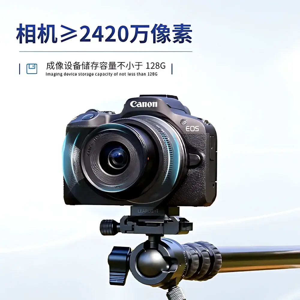
The COMECAUSE IN-GD10 Vegetation Cover Analyzer is a field-deployable, non-destructive optical measurement system engineered for quantitative assessment of vegetation cover fraction (VCF) and canopy closure in terrestrial ecosystems. It operates on the principle of digital image segmentation using spectral reflectance discrimination—leveraging the distinct chromatic response of green vegetation (high reflectance in NIR/red-edge, low in blue/green) against soil, rock, litter, or bare substrate backgrounds. Unlike manual ocular estimation or destructive sampling methods, the IN-GD10 delivers repeatable, operator-independent metrics traceable to standardized photogrammetric protocols. Its core architecture integrates a calibrated high-resolution DSLR imaging module (Canon EOS R50), embedded real-time image processing firmware, and a dedicated Android application that implements multi-threshold segmentation algorithms validated against ground-truth quadrat sampling per ISO 21746:2020 (Ecological monitoring — Field methods for vegetation structure assessment). Designed for operational use across agroecological zones, grassland restoration sites, afforestation projects, and watershed-scale land-cover inventories, the system meets the technical requirements for Tier-2 vegetation monitoring under the UNCCD Land Degradation Neutrality (LDN) framework.
Key Features
- High-fidelity imaging module: Canon EOS R50 DSLR with 24.2 MP CMOS sensor, 18–45 mm f/4.5–6.3 IS STM lens, optical auto-focus, automatic exposure compensation, and built-in flash assist for consistent illumination under variable ambient light conditions.
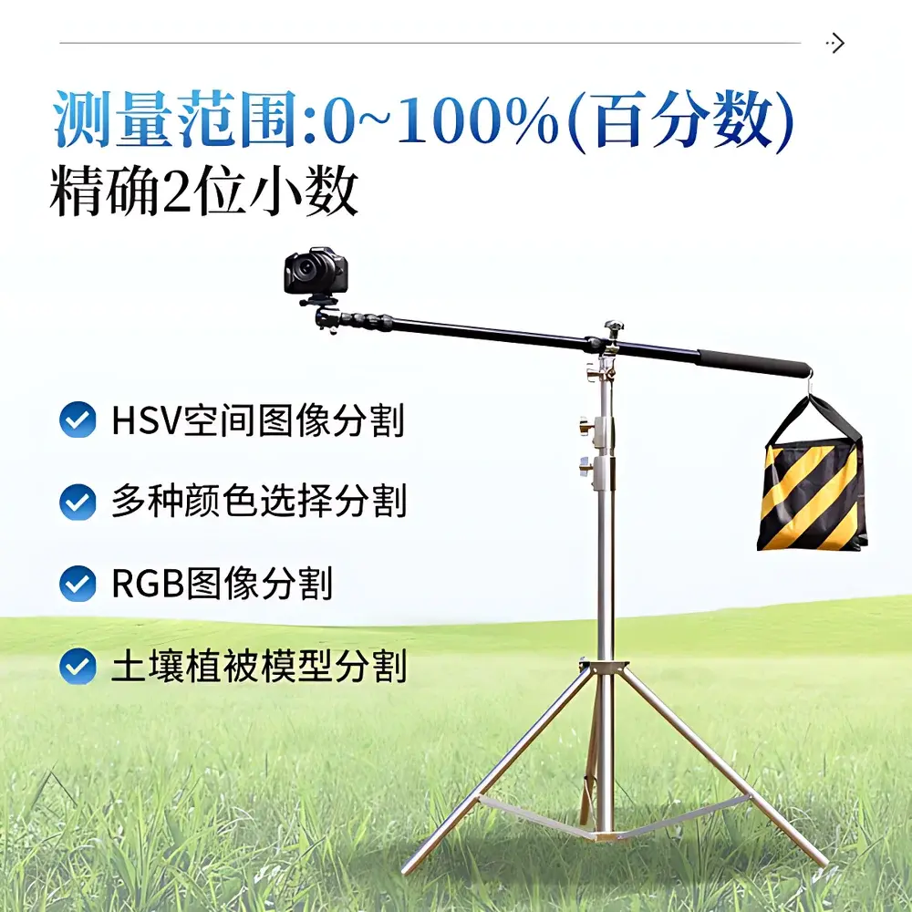
- Multi-algorithm segmentation engine: Supports RGB thresholding, HSV hue-saturation-value masking, user-defined color sampling, and pre-trained soil–vegetation spectral models optimized for temperate, arid, and alpine vegetation types.
- Robust field operation: Ruggedized aluminum tripod mount; operating temperature range –25°C to +55°C; relative humidity tolerance ≤80% RH; dust- and splash-resistant enclosure compliant with IP54 rating.
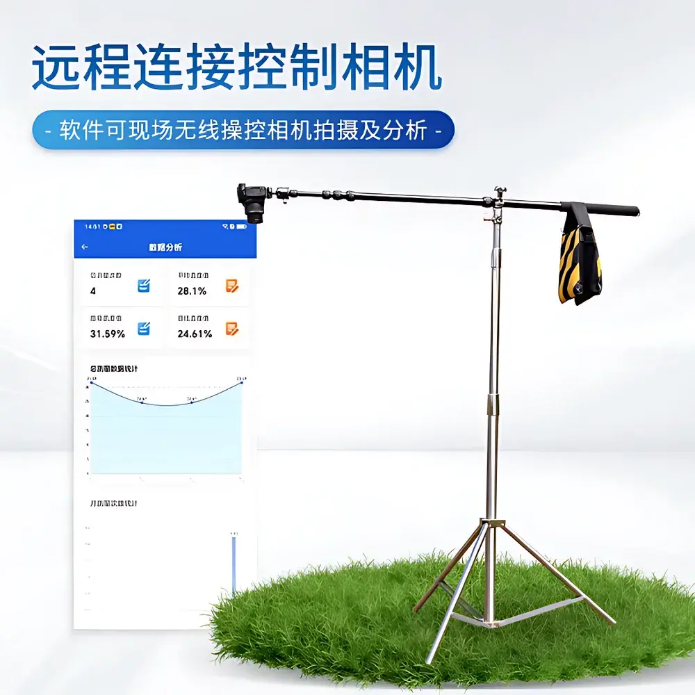
- Wireless workflow integration: Onboard Wi-Fi hotspot enables direct connection between Android tablet/smartphone and camera without external network infrastructure—critical for remote survey sites.
- Geo-referenced data capture: Integrated GPS (via paired Android device) embeds WGS84 coordinates, altitude, timestamp, and orientation into EXIF metadata for spatially explicit analysis and GIS interoperability.
- Scalable data management: Processes single images or batch directories (>50 MB per file); exports binary masks, color-coded overlays, statistical summaries, and full-resolution source images in PNG, JPEG, and BMP formats.
Sample Compatibility & Compliance
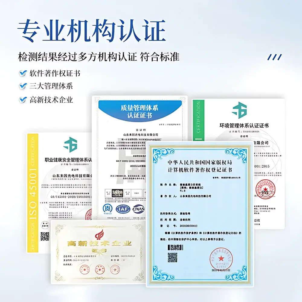
The IN-GD10 is validated for use across herbaceous, shrubby, and low-canopy woody vegetation communities—including perennial grasslands, cropland stubble, reforested slopes, mine rehabilitation plots, and riparian buffer zones. It excludes dense forest canopies (>8 m height) where vertical stratification requires LiDAR or hemispherical photography. The system adheres to internationally recognized validation benchmarks: classification accuracy ≥90% against quadrat-based reference data (n ≥ 50 plots per biome), repeatability CV 0.99). It supports compliance reporting for ISO 14064-2 (GHG project monitoring), FAO’s Global Forest Resources Assessment (FRA) indicators, and China’s HJ 1237–2022 standard for ecological condition monitoring. All software-generated outputs include audit-ready metadata logs satisfying GLP-aligned documentation requirements.
Software & Data Management
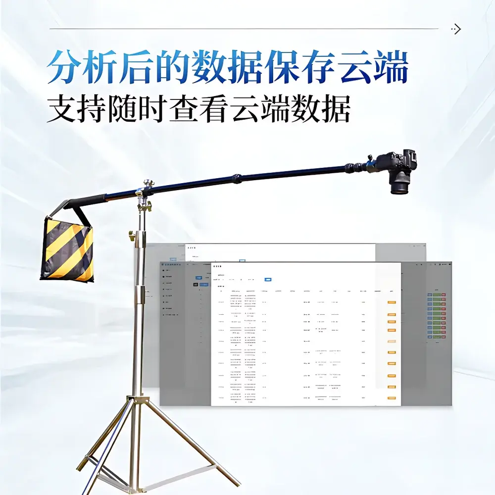
The Android application (v3.2+, compatible with Android 6.0+) provides a fully auditable analysis environment. Each session records full provenance: original image hash, applied segmentation method, threshold values, pixel count statistics, geographic coordinates, and user ID. Analysis results export to Excel (.xlsx) with columns for cover %, standard deviation, image filename, GPS coordinates, timestamp, and confidence flag. Cloud synchronization uses TLS 1.2–encrypted HTTPS endpoints; uploaded datasets retain immutable version history and support role-based access control (RBAC) for team collaboration. Offline functionality preserves all core analysis capabilities—no internet dependency during field acquisition. Software updates are delivered via signed APK packages with SHA-256 verification to ensure integrity and traceability.
Applications
- Agricultural monitoring: Quantifying crop emergence uniformity, intercropping density, residue coverage post-harvest, and weed infestation ratios for precision agronomy decisions.
- Grassland management: Tracking seasonal phenology, grazing pressure effects, and drought-induced dieback across pastoral systems—aligned with IUCN Red List habitat assessment criteria.
- Ecosystem restoration: Measuring success metrics for grassland reseeding, mine spoil revegetation, and coastal dune stabilization projects—supporting third-party verification under PES (Payment for Ecosystem Services) schemes.
- Natural resource inventory: Generating baseline VCF maps for national land-cover classification systems (e.g., China’s National Land Survey, USGS NLCD), supporting SDG Indicator 15.3.1 (Land Degradation Neutrality).
- Academic research: Enabling longitudinal studies on climate-driven vegetation shifts, invasive species spread, and fire recovery trajectories—compatible with R, Python (scikit-image, rasterio), and QGIS workflows.
FAQ
What is the minimum recommended shooting height and distance for optimal segmentation accuracy?
For homogeneous stands (e.g., wheat, alfalfa), maintain a nadir view at 1.2–2.0 m above canopy; for heterogeneous rangelands, 3.0–5.0 m using a telescoping pole or drone-mounted configuration (requires external gimbal stabilization).
Does the system support NDVI or other vegetation indices?
No—the IN-GD10 relies exclusively on visible-spectrum (RGB/HSV) segmentation to ensure compatibility with consumer-grade cameras and avoid calibration drift associated with unfiltered NIR sensors.
Can analysis parameters be exported and reused across projects?
Yes—threshold presets, color models, and region-of-interest (ROI) templates save as .cfg files and synchronize across devices via cloud backup.
Is raw image data retained after analysis?
Yes—source images remain unmodified on the camera’s SD card; only derivative products (binary masks, reports, overlays) are generated and stored separately.
How is measurement uncertainty quantified and reported?
The software calculates pixel-level classification confidence using ensemble voting across three segmentation modes (RGB, HSV, soil-vegetation model); final uncertainty is expressed as ±2σ of pixel-class agreement across five repeated analyses under fixed geometry.