COMECAUSE IN-GD20 Vegetation Canopy Cover Analyzer System
| Brand | COMECAUSE |
|---|---|
| Origin | Shandong, China |
| Manufacturer Type | Direct Manufacturer |
| Model | IN-GD20 |
| Measurement Principle | Hemispherical Digital Imaging + RGB/HSV Pixel-Based Canopy Segmentation |
| Optical Resolution | 8 MP Sensor with 25× Motorized Zoom (2–125 mm Focal Length) |
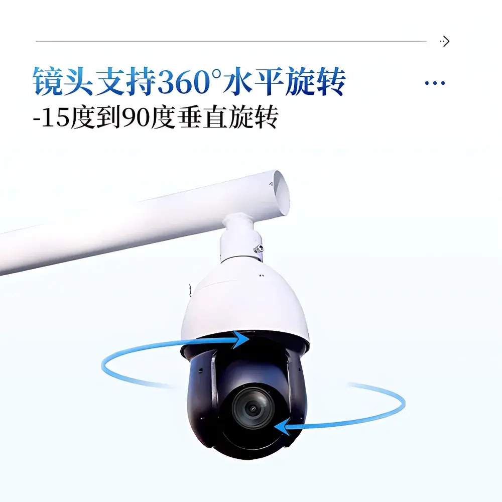
| Field of View | 360° Horizontal Rotation, −15° to +90° Vertical Tilt |
| Coverage Range | 0–100% (0.01% Resolution) |
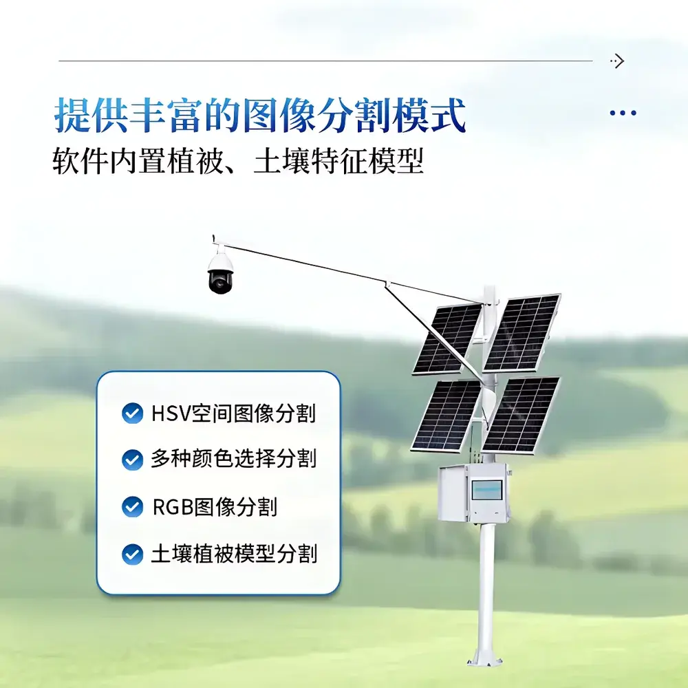
| Image Processing Modes | HSV Segmentation, RGB Thresholding, Soil-Vegetation Dual-Model Classification |
| Data Storage | 20 GB Onboard + USB Export + 4G Cloud Upload (Agricultural Data Center) |
| Power Supply | 200 W Solar Panel + 130 Ah Gel Battery (AC 220 V Backup) |
| Operating Environment | −40 °C to +55 °C, 0–100% RH |
| IP Rating | IP67 (Waterproof & Dustproof) |
| Software Compliance | Supports Audit Trail Logging, User Authentication (Admin Password), Geotagged Image Metadata (GPS), Exportable Excel Reports (CSV/XLSX), FDA 21 CFR Part 11–Ready Data Integrity Framework |
Overview
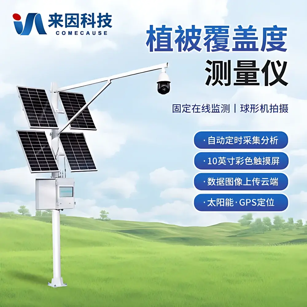
The COMECAUSE IN-GD20 Vegetation Canopy Cover Analyzer System is an engineered field-deployable instrument designed for quantitative, non-destructive measurement of vegetation cover fraction—the proportion of ground surface obscured by vertical projection of plant canopy elements (leaves, stems, branches). Ground-based hemispherical photography, coupled with pixel-level spectral segmentation in RGB and HSV color spaces, forms the core optical measurement principle. Unlike subjective visual estimation or grid-based manual sampling, the IN-GD20 applies geometrically calibrated image analysis to derive statistically robust cover estimates compliant with ISO 19115 metadata standards and FAO-recommended protocols for land cover assessment. Its architecture integrates optical imaging, embedded edge processing, georeferenced data acquisition, and cloud-synchronized telemetry—enabling long-term, unattended monitoring across agroecological gradients, from intensively managed croplands to arid rangelands and post-disturbance restoration sites.
Key Features
- 8-megapixel hemispherical imaging module with motorized 25× optical zoom (2–125 mm focal range), auto-focus, and adaptive exposure control for consistent low-light performance.
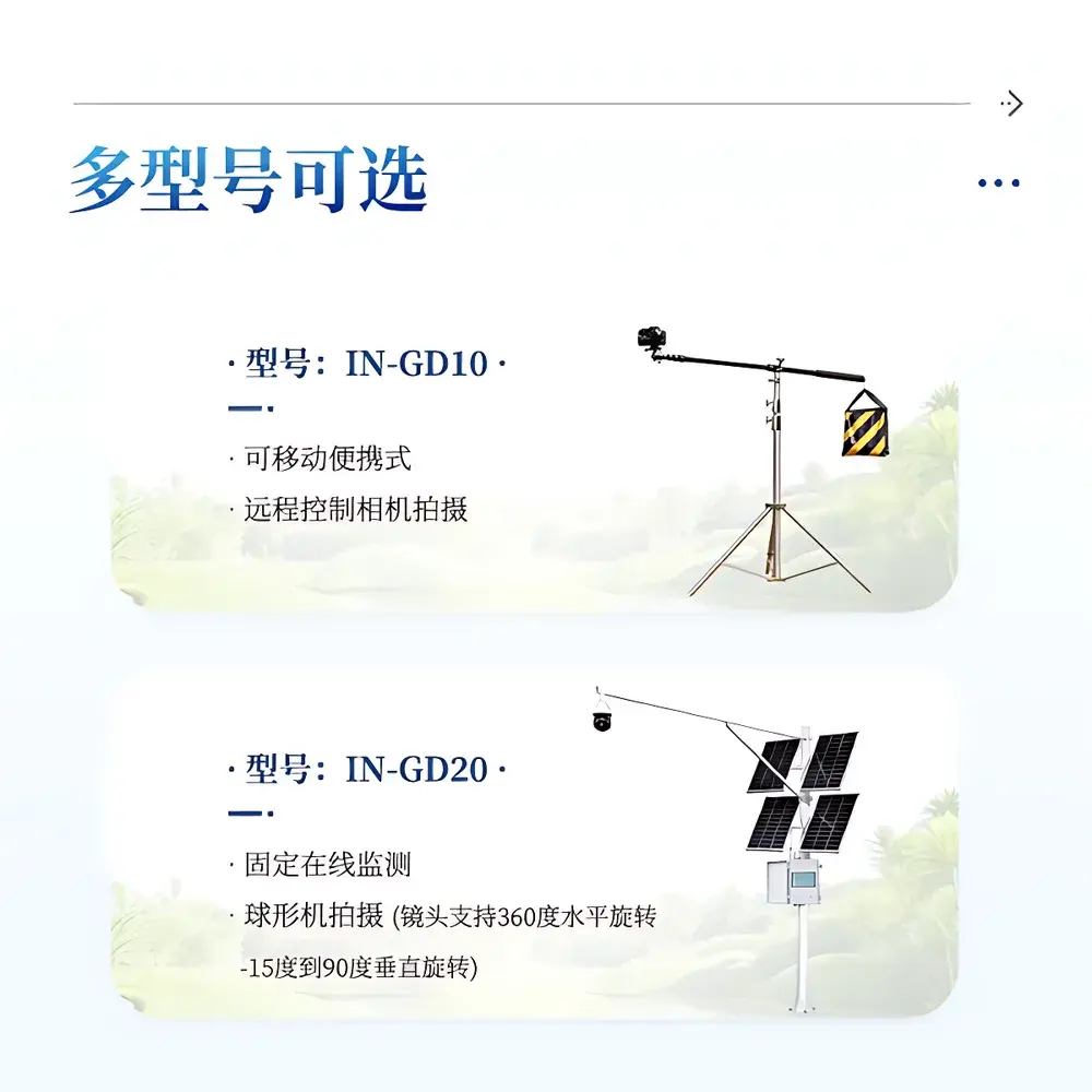
- Motorized pan-tilt head (360° azimuth, −15° to +90° elevation) enabling programmable multi-angle canopy capture without manual repositioning.
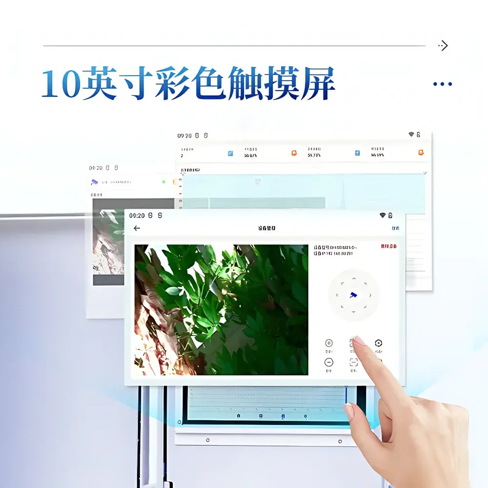
- 10-inch industrial-grade capacitive touchscreen interface with dual-language (English/Chinese) support, real-time threshold adjustment, and on-device binary/RGB overlay visualization.
- Embedded vegetation–soil discriminant model library, pre-trained across temperate, subtropical, and semi-arid biomes—reducing user-dependent calibration effort.
- Solar-powered autonomous operation: 200 W photovoltaic array + 130 Ah deep-cycle gel battery sustains continuous duty cycles under ≤72 h consecutive overcast conditions.
- GPS-synchronized acquisition scheduler: Configurable capture intervals from 30 minutes to 72 hours; automatic day/night mode switching based on local solar zenith angle.
- Comprehensive data provenance: Each image and derived metric includes embedded EXIF metadata (latitude/longitude, timestamp, sensor orientation, exposure settings, analysis parameters).
Sample Compatibility & Compliance
The IN-GD20 accommodates heterogeneous vegetation structures—including herbaceous monocultures (e.g., wheat, maize), shrub-steppe mosaics, young forest understories, and cryptogamic soil crusts—without physical contact or disturbance. Its segmentation algorithms are validated against ASTM D7971-22 (Standard Practice for Digital Image Analysis of Vegetation Cover) and align with USDA-NRCS National Resources Inventory (NRI) sampling protocols. The system meets IEC 60529 IP67 ingress protection requirements for outdoor deployment and operates within GLP-compliant workflows when paired with audit-trail-enabled software configuration. All stored and transmitted datasets retain immutable identifiers for traceability—supporting regulatory reporting under EU CAP Monitoring Framework and China’s Ecological Conservation Redline Policy.
Software & Data Management
The proprietary IN-GD20 Analytical Suite (v3.2+) provides a secure, role-based desktop and mobile environment for image ingestion, batch processing, and statistical reporting. It implements configurable user authentication (admin password lockout), session logging, and version-controlled parameter templates. Output formats include georeferenced PNG/JPEG/BMP images, binary masks, and Excel-compatible .xlsx reports containing mean cover %, standard deviation, pixel count distributions, and confidence intervals per acquisition. Data export paths support direct USB mass storage, encrypted 4G LTE upload to ISO 27001-certified agricultural cloud infrastructure, and API-driven integration with GIS platforms (ArcGIS Pro, QGIS) via OGC-compliant WFS endpoints. All raw and processed files adhere to FAIR principles (Findable, Accessible, Interoperable, Reusable) and are structured according to Darwin Core and Agronomy Ontology (AgroO) schema conventions.
Applications
- Precision Agriculture: Quantifying crop emergence uniformity, canopy closure timing, and nitrogen-use efficiency proxies through longitudinal cover trajectories correlated with yield models (e.g., APSIM, DSSAT).
- Rangeland & Grassland Ecology: Tracking degradation/recovery dynamics in semi-arid systems using NDVI-informed cover thresholds aligned with UNCCD Land Degradation Neutrality indicators.
- Forestry & Silviculture: Estimating stand-level leaf area index (LAI) surrogates and crown closure metrics for inventory updates and fire risk modeling (NFPA 1141).
- Soil Erosion Modeling: Providing input parameters for RUSLE and WEPP models by delivering spatially explicit cover maps at sub-field resolution.
- Urban Green Infrastructure: Validating green roof performance, park canopy equity indices, and street tree density compliance against WHO Urban Green Space Guidelines.
- Climate Change Research: Supporting phenocam networks by generating time-series cover metrics for cross-site comparisons of spring green-up and autumn senescence shifts.
FAQ
What optical principle does the IN-GD20 use to calculate vegetation cover?
It employs downward-facing hemispherical digital imaging combined with pixel classification in HSV and RGB color spaces, calibrated against known sky–canopy geometry models (e.g., Gap Fraction Theory).
Does the system require manual calibration for different vegetation types?
No—pre-loaded soil–vegetation discriminant models reduce calibration dependency, though users may refine thresholds using region-specific training images.
How is data integrity ensured during wireless transmission?
All 4G uploads use TLS 1.3 encryption; each dataset carries a SHA-256 hash signature and timestamped digital certificate for tamper detection.
Can the IN-GD20 integrate with existing farm management information systems (FMIS)?
Yes—via RESTful API and standardized CSV/GeoJSON exports compatible with Climate FieldView, Granular, and AgriWebb platforms.
Is the device suitable for polar or high-altitude deployments?
Rated for −40 °C operation and tested up to 4,500 m ASL; cold-start firmware ensures reliable boot at sub-zero temperatures.
Related Products


