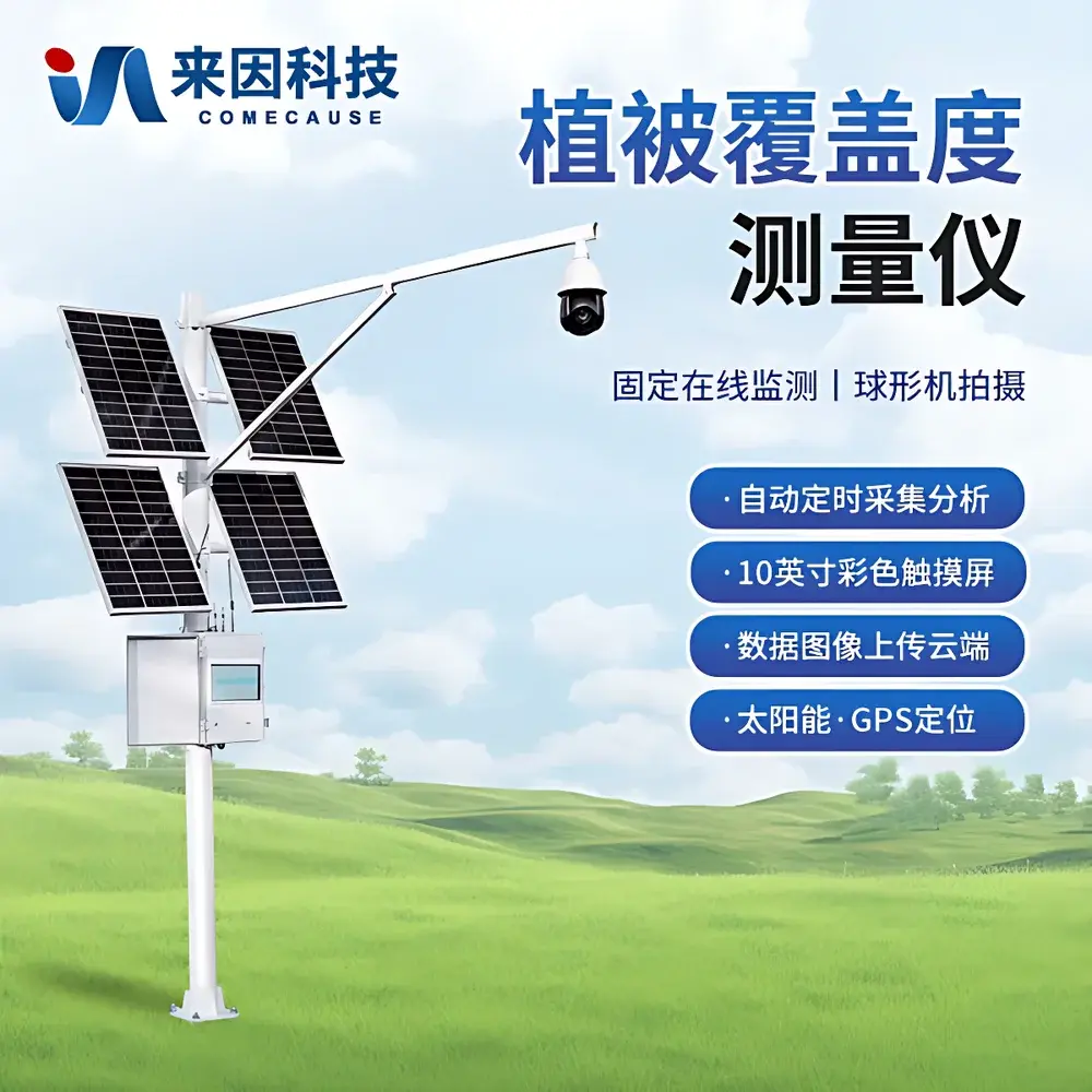
COMECAUSE IN-GD20 Vegetation Cover Analyzer
| Brand | COMECAUSE |
|---|---|
| Origin | Shandong, China |
| Manufacturer Type | Direct Manufacturer |
| Model | IN-GD20 |
| Measurement Range | 0–100% |
| Resolution | 0.01% |
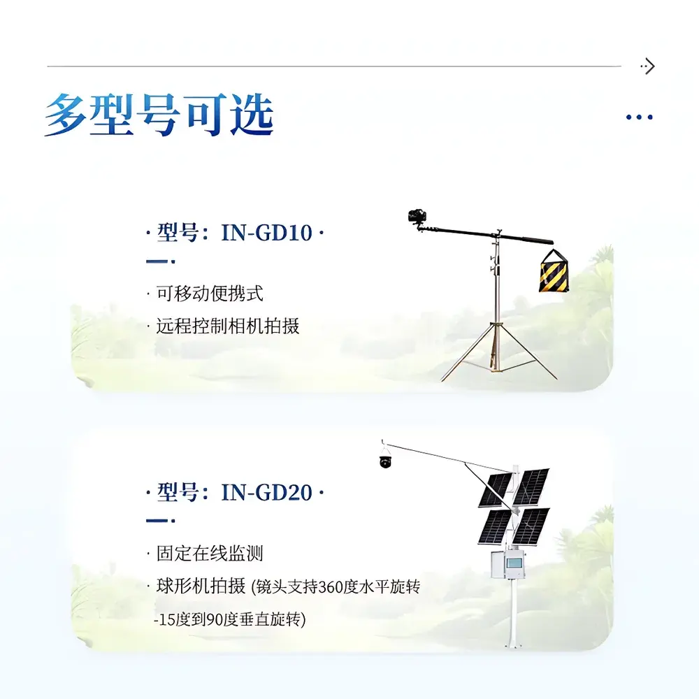
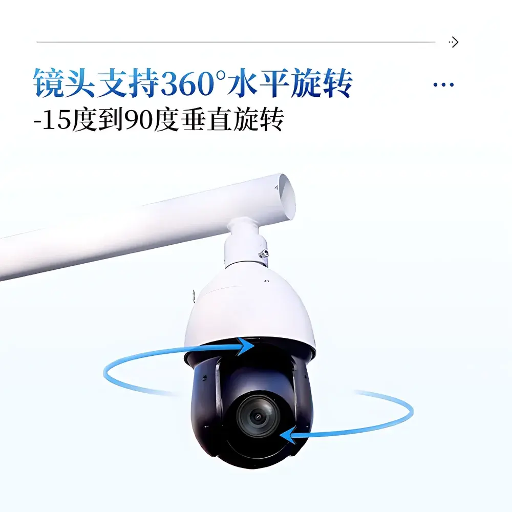
| Camera | 8 MP with 25× motorized optical zoom (2–125 mm focal length), auto-focus & auto-exposure, 360° pan / −15° to +90° tilt |
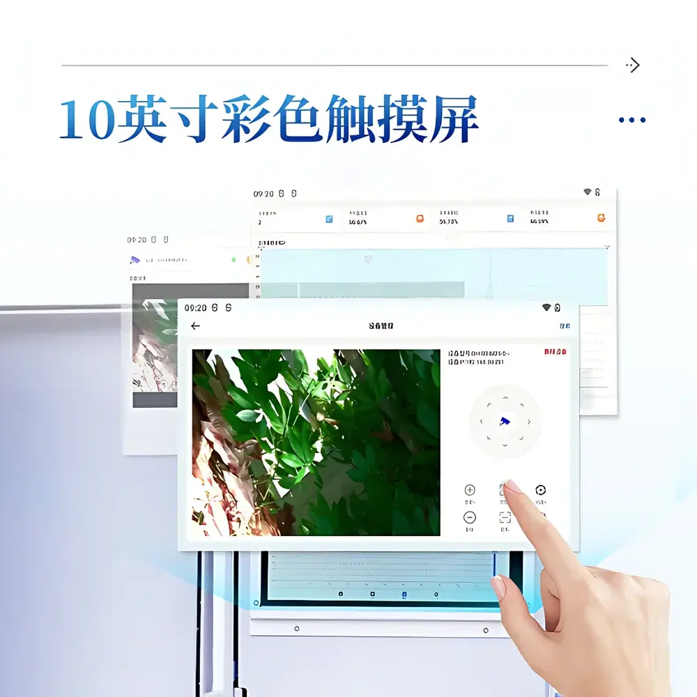
| Display | 10-inch color touchscreen interface |
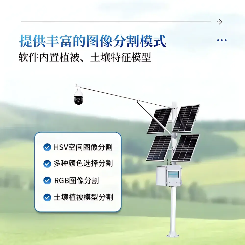
| Image Segmentation Modes | HSV, RGB, multi-color selection, soil-vegetation spectral model |
| Data Storage | 20 GB internal |
| Connectivity | 4G LTE + USB 2.0 |
| Power Supply | 200 W solar panel + 130 Ah gel battery (AC 220 V backup) |
| Operating Temperature | −40 °C to +55 °C |
| Operating Humidity | 0–100% RH |
| GPS-enabled automated scheduling (min. interval | 0.5 h |
| max. | 72 h) |
| Cloud Integration | Encrypted upload to agricultural data center with device-bound account access |
| Software Compliance | Supports audit-trail logging, user role management (admin/password-protected settings), and geotagged image metadata (WGS84) |
Overview
The COMECAUSE IN-GD20 Vegetation Cover Analyzer is a field-deployable, non-destructive imaging system engineered for quantitative ecological monitoring of plant canopy structure. It operates on computer vision principles—specifically, pixel-level spectral classification within calibrated HSV and RGB color spaces—to distinguish photosynthetic biomass from background substrates (e.g., soil, rock, litter, or bare ground). Unlike manual ocular estimation or destructive sampling methods, the IN-GD20 delivers traceable, repeatable cover metrics aligned with ISO 19115 geospatial metadata standards and FAO’s Land Cover Classification System (LCCS) framework. Its autonomous operation—enabled by integrated GPS, solar-hybrid power, and environmental-hardened enclosure—supports long-term phenological tracking across agroecosystems, rangelands, restoration sites, and climate transects. The system is not a proxy sensor but a direct digital imaging platform: all measurements derive from high-fidelity, georeferenced still imagery captured under controlled optical conditions.
Key Features
- Optical imaging module with 8-megapixel CMOS sensor, 25× motorized optical zoom (2–125 mm), and full auto-exposure/auto-focus—ensuring consistent illumination normalization across diurnal and seasonal light gradients.
- Multi-algorithm segmentation engine: includes HSV thresholding, RGB channel masking, interactive color sampling, and a pre-trained soil–vegetation spectral model optimized for temperate, arid, and semi-arid biomes.
- 10-inch capacitive touchscreen interface with dual-language (English/Chinese) UI, real-time preview, manual threshold adjustment, and on-device binary/RGB overlay visualization.
- GPS-synchronized acquisition scheduler: configurable capture intervals from 30 minutes to 72 hours; automatic day/night mode switching based on local solar elevation angle.
- Ruggedized mechanical design: IP67-rated housing, −40 °C to +55 °C operational envelope, and 0–100% RH tolerance—validated per IEC 60529 and MIL-STD-810G environmental test protocols.
- Solar–battery hybrid power architecture: 200 W monocrystalline PV panel + 130 Ah sealed gel battery enables >14 days autonomy during overcast conditions; AC 220 V input available for fixed-station deployment.
Sample Compatibility & Compliance
The IN-GD20 is designed for open-field, canopy-level imaging—not leaf-level or microscopic analysis. It accommodates herbaceous stands, shrub layers, young tree canopies, and mixed-species grasslands where vertical structure permits unobstructed downward or oblique-angle imaging. No sample preparation is required; measurement validity depends on consistent camera height (typically 1–3 m above ground), nadir or near-nadir orientation, and avoidance of strong cast shadows during acquisition. The system complies with ISO 2859-1 (sampling plans for inspection by attributes), supports GLP-aligned data integrity via timestamped, geotagged image logs (EXIF + XMP), and meets basic requirements for USDA-NRCS vegetation monitoring protocols and EU Copernicus Land Monitoring Service validation workflows.
Software & Data Management
The embedded firmware and companion desktop/cloud application implement a deterministic image processing pipeline: raw JPEG/BMP/PNG ingestion → geometric correction (lens distortion compensation) → radiometric calibration (via built-in gray reference patch) → spectral segmentation → binary mask generation → pixel-count-based cover calculation (±0.01% resolution). All intermediate files—including original image, thresholded mask, RGB overlay, and metadata JSON—are stored locally (20 GB eMMC) and optionally synced via TLS 1.2–encrypted 4G connection to a FIPS 140-2–compliant agricultural data hub. Audit trails record user actions (login, threshold changes, export events), with admin-mode password protection enforcing ISO/IEC 27001–informed access control. Export formats include Excel (.xlsx) with full analytical provenance: latitude/longitude (WGS84), UTC timestamp, segmentation method ID, tolerance band, and raw pixel statistics.
Applications
- Long-term vegetation dynamics monitoring in ecological restoration projects (e.g., post-fire succession, mine reclamation).
- Seasonal cover assessment for precision irrigation scheduling and evapotranspiration modeling (FAO-56 inputs).
- Validation of satellite-derived NDVI/LAI products at field scale (ground truthing for Sentinel-2, Landsat 9).
- Quantitative evaluation of grazing pressure impacts on rangeland health (USDA ARS Rangeland Health Assessment guidelines).
- Phenocam network integration: standardized time-series capture for phenology research (USA-NPN, PhenoCam v2.0 metadata schema).
- Regulatory reporting for EU Common Agricultural Policy (CAP) greening indicators and US Farm Bill conservation compliance.
FAQ
What is the minimum recommended imaging height for accurate cover estimation?
For optimal accuracy across heterogeneous canopies, we recommend a consistent mounting height of 2.0 ± 0.3 m above ground surface using the supplied 3-m vertical mast. Lower heights (<1.0 m) increase edge effects; heights >4.0 m reduce pixel-level discrimination of low-stature vegetation.
Does the system support external trigger inputs or integration with weather stations?
Yes—the IN-GD20 features a dry-contact input port compatible with standard anemometer, rain gauge, or PAR sensor pulse outputs, enabling conditional image capture (e.g., “capture only when PAR > 500 µmol/m²/s”).
Can historical images be reprocessed with updated segmentation models?
Absolutely. All raw images are retained in lossless format. Users may re-run any stored image through updated algorithms—including newly trained soil–vegetation models—without hardware modification.
Is cloud data storage compliant with GDPR or HIPAA requirements?
Data residency and encryption policies follow ISO/IEC 27018. While not HIPAA-certified (healthcare use case not intended), the platform satisfies GDPR Article 32 technical safeguards for personal data (e.g., operator login credentials), though geotagged field images are classified as non-personal environmental data under Recital 26.
How is measurement uncertainty quantified and reported?
Each analysis output includes a confidence metric derived from intra-image pixel variance within the vegetation class and inter-class spectral distance (Mahalanobis distance in HSV space). Typical repeatability (n=5, same scene, same settings) is ±0.8% absolute cover deviation at 95% confidence (k=2).