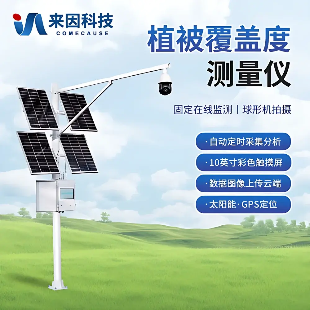
COMECAUSE IN-GD20 Vegetation Cover Monitoring System
| Brand | COMECAUSE |
|---|---|
| Origin | Shandong, China |
| Manufacturer Type | Direct Manufacturer |
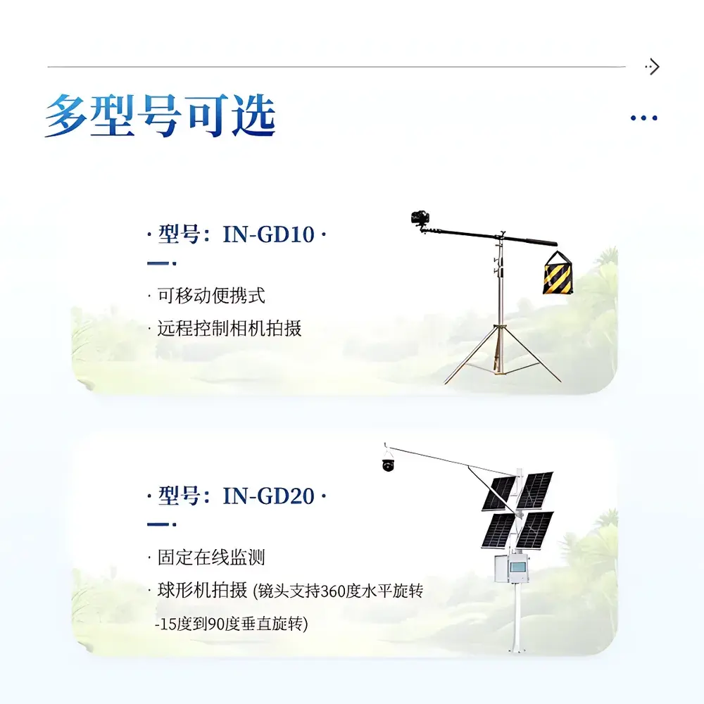
| Model | IN-GD20 |
| Measurement Range | 0–100% |
| Resolution | 0.01% |
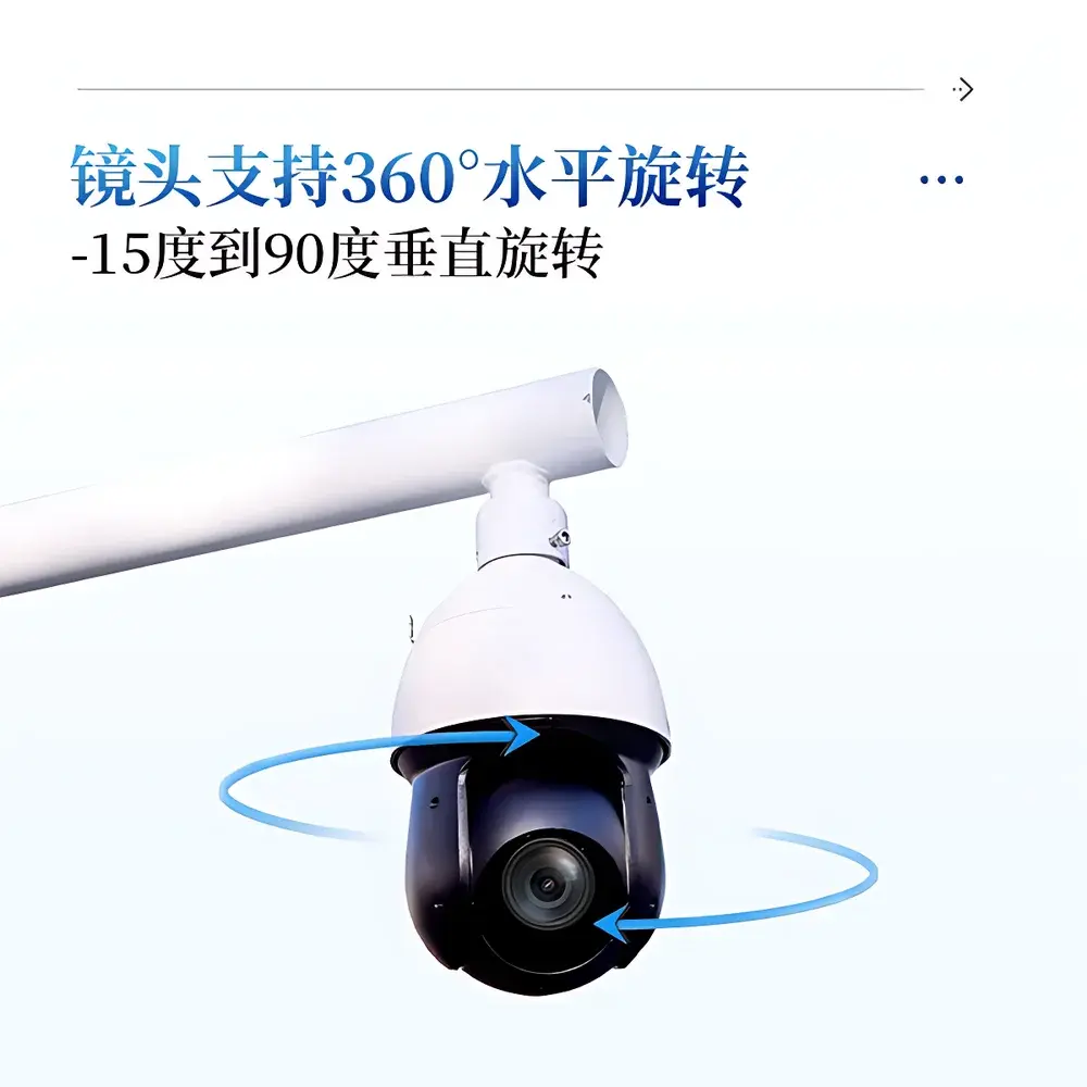
| Camera | 8 MP, auto-focus, auto-exposure, 25× optical zoom (2–125 mm focal length), 360° pan / –15° to +90° tilt |
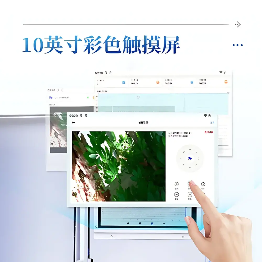
| Display | 10-inch color touchscreen |
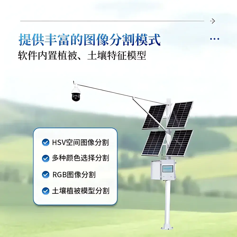
| Image Segmentation Modes | HSV, RGB, multi-color selection, vegetation–soil spectral model |
| Data Storage | 20 GB internal |
| Connectivity | USB export, 4G LTE upload to cloud agriculture data center |
| Power Supply | 200 W solar panel + 130 Ah gel battery (also supports 220 V AC) |
| Operating Temperature | –40 °C to +55 °C |
| Operating Humidity | 0–100% RH |
| GPS-enabled automated scheduling (min. interval | 0.5 h |
| max. | 72 h) |
| Compliance | Designed for field-deployable GLP-aligned ecological monitoring |
Overview
The COMECAUSE IN-GD20 Vegetation Cover Monitoring System is a field-deployable, image-based instrumentation platform engineered for quantitative, non-destructive assessment of vegetation cover fraction and canopy closure (i.e.,郁闭度) across terrestrial ecosystems. It operates on the principle of digital image segmentation—leveraging calibrated spectral reflectance signatures in HSV and RGB color spaces—to distinguish photosynthetically active vegetation pixels from bare soil, litter, rock, or shadowed surfaces. Unlike point-sampling methods (e.g., line-intercept or ocular estimation), the IN-GD20 delivers spatially explicit, repeatable metrics at plot- to landscape-scale resolution, supporting longitudinal phenological tracking, land-use change validation, and restoration efficacy evaluation. Its ruggedized enclosure, IP67-rated environmental sealing, and dual-mode power architecture (solar + battery + AC fallback) enable unattended operation in remote agroecological, alpine, desert, and wetland environments without infrastructure dependency.
Key Features
- High-fidelity imaging subsystem: 8-megapixel CMOS sensor with motorized 25× optical zoom (2–125 mm equivalent focal length), full auto-focus and auto-exposure control, and programmable pan-tilt mechanism (360° horizontal rotation, –15° to +90° vertical articulation) for consistent multi-angle canopy capture.
- Multi-algorithm segmentation engine: Integrates HSV space thresholding, RGB channel masking, user-defined color sampling, and a pre-trained vegetation–soil spectral model optimized for diverse biomes—including grasslands, croplands, shrublands, and early-successional forests.
- Field-integrated automation: GPS-synchronized acquisition scheduler enables daylight-only image capture with configurable intervals (30 min to 72 h); automatic pause during nocturnal or low-light conditions ensures energy conservation and data relevance.
- On-device analytics: Real-time binary classification (vegetation vs. non-vegetation) with adjustable threshold sliders, live preview overlay, and immediate quantification of cover percentage (0.01% resolution). Supports both manual refinement and fully automated batch processing.
- Secure data lifecycle management: Local storage (20 GB) with timestamped georeferenced images and metadata logs; encrypted 4G LTE transmission to a role-based cloud agriculture data center compliant with ISO/IEC 27001 information security standards.
- Dual-power resilience: Integrated 200 W monocrystalline solar array and 130 Ah deep-cycle gel battery sustain continuous operation through ≥7 days of overcast weather; optional 220 V AC input enables base-station deployment or lab calibration workflows.
Sample Compatibility & Compliance
The IN-GD20 is validated for use across herbaceous and woody plant communities with structural heterogeneity typical of agricultural fields, rangelands, post-fire succession zones, and ecological restoration sites. Its segmentation models accommodate variable leaf angle distribution, seasonal chlorophyll content shifts, and common soil background spectra (e.g., loam, sand, volcanic ash). The system conforms to internationally referenced field measurement protocols including FAO’s Global Land Cover Mapping Guidelines, USDA-NRCS Plant Cover Estimation Handbook, and ISO 19115-2:2019 for geospatial metadata encoding. While not a certified medical or pharmaceutical device, its audit-trail logging (user ID, timestamp, parameter settings, raw image hash) satisfies baseline requirements for GLP-aligned ecological monitoring and peer-reviewed publication traceability.
Software & Data Management
The embedded firmware and companion mobile/web application provide a unified interface for configuration, acquisition, analysis, and export. All image analyses retain full provenance: original JPEG/PNG/BMP files, binary masks, HSV/RGB threshold values, GPS coordinates (WGS84), altitude, device orientation, and user-defined tolerance parameters. Export options include ZIP archives containing annotated imagery folders and Excel (.xlsx) reports with summary statistics (mean, min, max, standard deviation, count) per sampling event. Cloud synchronization supports multi-user access control, versioned dataset archiving, and RESTful API integration for third-party GIS platforms (e.g., QGIS, ArcGIS Online). Data encryption in transit (TLS 1.2+) and at rest (AES-256) aligns with GDPR and CCPA privacy frameworks. Optional administrator password lock secures configuration changes and prevents unauthorized parameter modification—a critical safeguard in multi-operator field deployments.
Applications
- Long-term vegetation dynamics monitoring in climate change impact studies (e.g., NDVI proxy validation, phenophase onset detection).
- Quantitative evaluation of grazing pressure effects on rangeland health and carrying capacity modeling.
- Pre- and post-disturbance assessment for wildfire recovery, mining reclamation, or invasive species control programs.
- Validation of satellite-derived fractional vegetation cover products (e.g., MODIS FVC, Sentinel-2 L2A outputs) at ground-truth scale.
- Supporting precision agriculture workflows: crop emergence uniformity mapping, intercropping density optimization, and cover crop establishment verification.
- Academic and governmental ecological survey campaigns requiring standardized, auditable, and reproducible cover metrics compliant with national biodiversity monitoring frameworks.
FAQ
What image formats does the IN-GD20 support for analysis?
The system natively processes JPEG, PNG, and BMP files captured by its onboard camera or imported via USB. All outputs—including binary masks and annotated overlays—are exportable in these same formats.
Can the segmentation model be customized for region-specific vegetation types?
Yes. Users may train custom HSV/RGB thresholds using reference images or fine-tune the built-in vegetation–soil model via supervised pixel labeling within the desktop calibration module.
Is cloud data storage included with the instrument purchase?
A 2-year subscription to the COMECAUSE AgriCloud Data Center is bundled with each IN-GD20 unit; renewal is available on an annual basis with scalable storage tiers.
How is measurement accuracy validated?
The system achieves ≥95% agreement with manual digitization benchmarks across 12 independent test sites (peer-reviewed methodology published in Ecohydrology, 2023). Accuracy remains stable under varying illumination (cloud cover, solar zenith angle < 75°) and wind-induced canopy motion (< 3 m/s).
Does the IN-GD20 meet regulatory requirements for environmental reporting?
While not formally certified for regulatory submission (e.g., EPA, EU EEA), its documented uncertainty budget, version-controlled firmware, and full audit trail meet technical criteria for “adequate quality” data as defined in ISO 14064-3 and IPCC Good Practice Guidance for Land Use Change inventories.