COMECAUSE IN*NDVI Portable Multispectral NDVI Analyzer
| Brand | COMECAUSE |
|---|---|
| Origin | Shandong, China |
| Manufacturer Type | Direct Manufacturer |
| Model | IN*NDVI |
| Sensor Resolution | 5 MP (RGB), 8 MP (NIR) |
| Spectral Bands | Red (650 nm ±5 nm), NIR (850 nm ±5 nm) |
| FOV | 80° (RGB & NIR), 180° (Fisheye Canopy Lens) |
| Display | 8-inch 700-nit outdoor-readable touchscreen |
| Battery Life | ~7 hours (5550 mAh Li-ion) |
| Operating Temp | −20 °C to +60 °C |
| Humidity Range | 0–95% RH (non-condensing) |
| Weight | 3.0 kg |
| Dimensions | ~140 cm (extended length) |
| OS | Android 12 |
| Onboard Storage | 256 GB SSD |
| RAM | 16 GB |
| Connectivity | GPS/Beidou, 4G LTE, Wi-Fi 5, Bluetooth 5.0 |
| Data Export | CSV, Excel, GeoTIFF, Pseudocolor PNG, RAW multispectral images |
| Compliance | Supports GLP-aligned field data capture with timestamped metadata, georeferenced logging, and audit-ready export logs |
Overview
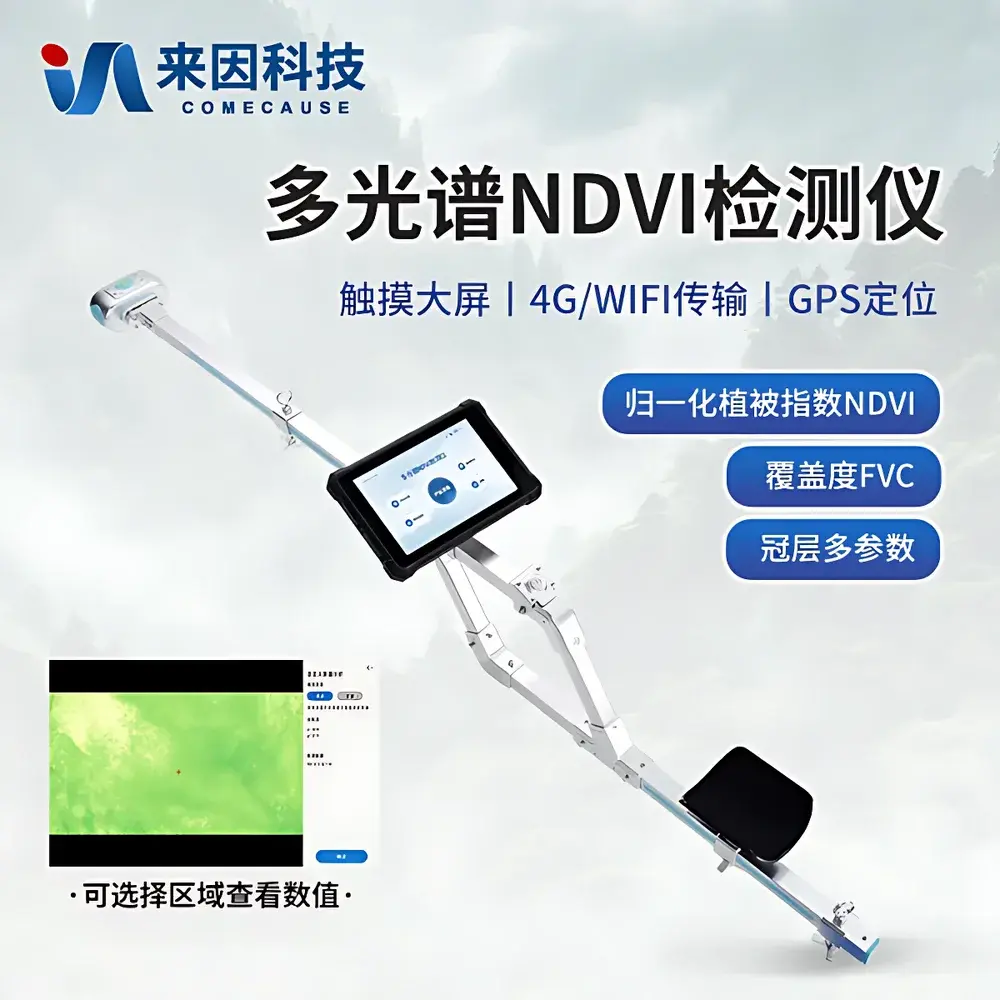
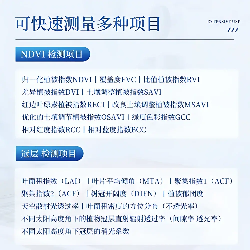
The COMECAUSE IN*NDVI Portable Multispectral NDVI Analyzer is an engineered field-deployable instrument designed for in-situ, real-time quantification of vegetation physiological status using calibrated multispectral reflectance measurements. It operates on the fundamental principle of spectral vegetation index derivation—leveraging the strong absorption of red light (~650 nm) by chlorophyll and high reflectance of near-infrared radiation (~850 nm) from healthy mesophyll tissue. By capturing synchronized, co-registered RGB and narrowband red/NIR imagery under ambient illumination, the device computes the Normalized Difference Vegetation Index (NDVI) and 11 additional biophysically grounded indices—including FVC (Fractional Vegetation Cover), LAI (Leaf Area Index), SAVI, OSAVI, RECI, GCC, and DIFN—with pixel-level spatial resolution down to <1 cm at 1 m working distance. Unlike satellite or UAV-based systems constrained by revisit frequency, cloud cover, and radiometric calibration drift, the IN*NDVI delivers laboratory-grade spectral fidelity in handheld form—enabling immediate ground-truthing, validation of remote sensing products, and detection of sub-visual plant stress prior to morphological expression.
Key Features
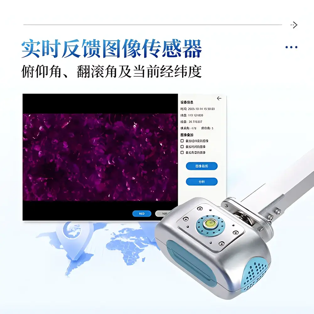
- Integrated dual-sensor architecture: 5 MP RGB CMOS sensor (80° FOV) and 8 MP monochrome NIR sensor (80° FOV, peak response at 850 nm ±5 nm, FWHM ≤10 nm), both optically aligned and mechanically stabilized
- Dedicated 180° fisheye canopy lens for hemispherical sky-view imaging, enabling robust LAI, MTA (Mean Tilt Angle), and ACF (Clumping Index) estimation via gap fraction analysis
- Real-time onboard computation of 12 vegetation indices with embedded geotagging, orientation metadata (roll/pitch/yaw), and solar geometry correction
- 8-inch 700-nit sunlight-readable capacitive touchscreen with glove-compatible operation and intuitive Android 12 interface optimized for field use
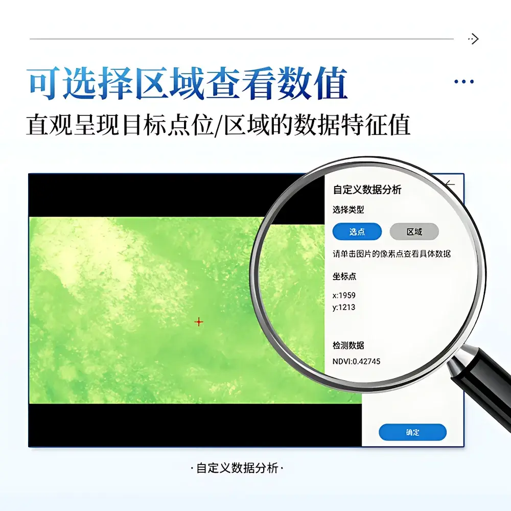
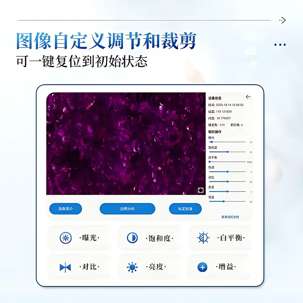
- Full manual control over exposure, white balance, saturation, contrast, brightness, and gain—plus one-click reset and region-of-interest (ROI) cropping
- Automated threshold optimization for binary segmentation, eliminating subjective threshold selection bias in FVC and canopy classification workflows
- Ergonomic carbon-fiber pole (140 cm extended), shoulder strap, and elbow support for fatigue-free operation during extended transects or plot surveys
Sample Compatibility & Compliance
The IN*NDVI is validated for non-destructive, contactless measurement across diverse vegetation structures—including herbaceous canopies (grasses, crops), shrub layers, forest understory, wetland macrophytes, and orchard canopies. Its 180° fisheye mode supports both upward-looking (under-canopy sky view) and downward-looking (over-canopy ground view) configurations. All optical components undergo factory spectral calibration traceable to NIST-traceable standards; spectral bandpass characteristics are documented per unit in the delivered calibration certificate. Data acquisition conforms to FAO’s Good Practice Guidance for Field Spectroscopy and aligns with ISO 11120:2022 (Field Measurement of Canopy Structure) and ASTM E2920-23 (Standard Guide for Remote Sensing Data Validation). Timestamped, georeferenced image stacks and derived indices support GLP-compliant field documentation—each export includes full metadata (GPS coordinates, UTC time, sensor orientation, ambient illuminance estimate, and battery level).
Software & Data Management
The embedded Android 12 platform hosts a purpose-built field analytics suite supporting offline operation without cloud dependency. All raw and processed data—including EXIF-embedded multispectral TIFFs, pseudocolor visualizations, statistical summaries (mean/SD/min/max per ROI), and temporal trend charts—are stored locally on the 256 GB SSD. Users may define custom analysis zones (up to 10 × 10 zenith/azimuth grid partitions), mask invalid pixels (e.g., soil exposure, edge artifacts), and generate comparative reports across dates or treatments. Data export options include USB-C mass storage mode (CSV, Excel, GeoTIFF, PNG) and secure 4G LTE upload to the optional COMECAUSE AgriCloud™ platform—where users access role-based dashboards, time-series interpolation tools, and API endpoints compliant with OGC SensorThings API v1.1. Audit trails record all parameter changes, ROI selections, and export actions with user ID and timestamp—meeting basic requirements for FDA 21 CFR Part 11–aligned field data integrity where local regulatory frameworks apply.
Applications
- Precision Agriculture: Generation of prescription maps for variable-rate irrigation, nitrogen application, and targeted pesticide deployment based on within-field NDVI heterogeneity
- Plant Breeding & Phenotyping: High-throughput screening of germplasm under abiotic (drought, salinity) and biotic (pathogen inoculation) stress trials, with daily NDVI trajectory tracking
- Ecological Monitoring: Long-term assessment of grassland degradation, wetland restoration efficacy, and forest canopy dynamics following disturbance events
- Forestry Inventory: Estimation of LAI, canopy closure, and light penetration profiles in mixed-species stands without destructive sampling
- Remote Sensing Ground Truthing: Collection of reference spectra and index values for atmospheric correction and classification accuracy assessment of Sentinel-2, Landsat, or drone-derived products
- Education & Extension: Demonstrating spectral plant physiology principles in undergraduate agronomy, ecology, and environmental science curricula
FAQ
What spectral bands does the IN*NDVI measure, and how are they calibrated?
The device measures reflectance in two discrete bands: red (centered at 650 nm, FWHM ≤10 nm) and near-infrared (centered at 850 nm, FWHM ≤10 nm), alongside full RGB. Each unit ships with individual spectral response function (SRF) characterization and factory calibration against NIST-traceable reflectance standards.
Can the IN*NDVI operate under low-light or overcast conditions?
Yes—its high-sensitivity sensors and adjustable exposure/gain allow reliable operation from dawn to dusk; however, NDVI interpretation assumes Lambertian surface assumptions and is most robust under diffuse illumination (e.g., overcast skies). Direct sun angles >60° require careful shadow masking in post-processing.
Is the fisheye lens removable or interchangeable?
No—the 180° fisheye lens is permanently integrated and optically aligned with the NIR/RGB sensors to ensure geometric consistency for canopy structure algorithms. Its fixed configuration eliminates parallax errors critical for gap fraction modeling.
Does the system support third-party GIS integration?
Yes—exported GeoTIFFs contain embedded WGS84 georeferencing and projection metadata compatible with QGIS, ArcGIS Pro, and ENVI. The AgriCloud™ platform also provides RESTful APIs for direct ingestion into enterprise spatial databases.
How is data security and user access managed?
Local data is protected by optional administrator password lockout; cloud uploads require authenticated session tokens. All exported files include SHA-256 checksums. No telemetry or usage data is transmitted without explicit user consent.
Related Products


