COMECAUSE IN-NDVI Non-Contact Multispectral NDVI Measurement System
| Brand | COMECAUSE |
|---|---|
| Origin | Shandong, China |
| Manufacturer Type | Direct Manufacturer |
| Product Origin | Domestic (China) |
| Model | IN-NDVI |
| Price | USD 11,800 (approx.) |
Overview
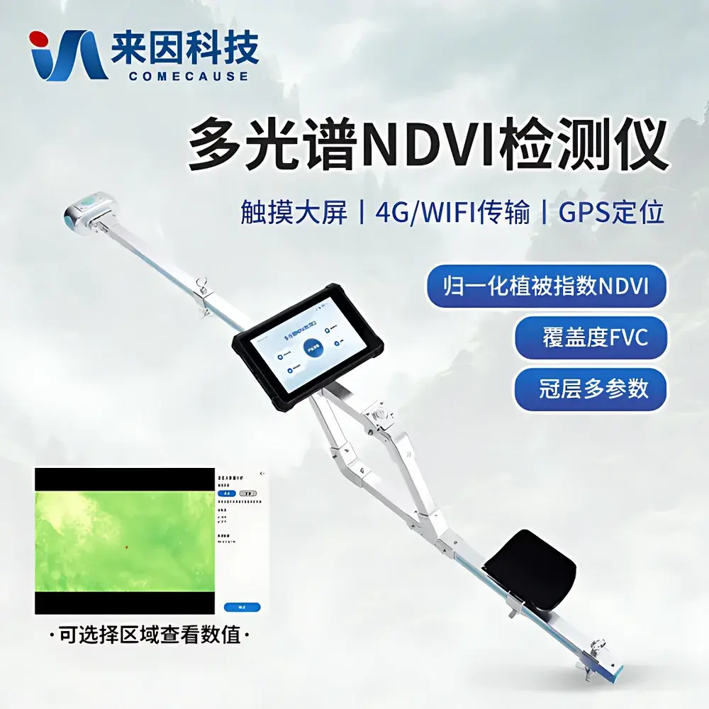
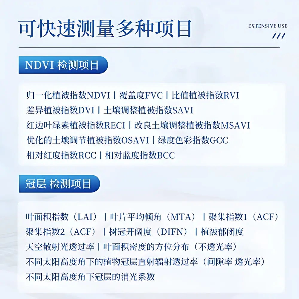
The COMECAUSE IN-NDVI is a field-deployable, non-contact multispectral imaging system engineered for quantitative plant phenotyping and canopy structural analysis. It operates on the principle of spectral reflectance ratioing—specifically calculating the Normalized Difference Vegetation Index (NDVI) as (NIR − Red)/(NIR + Red), using calibrated narrowband sensors centered at 650 nm (red) and 850 nm (NIR, FWHM = 10 nm). Unlike passive satellite or drone-based NDVI estimation, the IN-NDVI integrates synchronized RGB, red, and near-infrared imaging with inertial measurement and georeferencing to deliver ground-truthed, spatially resolved vegetation indices under variable ambient lighting. Its dual-capture capability—upward-looking fisheye (180° FOV) for canopy architecture analysis and downward-looking (80° FOV) for plot-scale surface assessment—enables simultaneous acquisition of structural (LAI, MTA, ACF, DIFN) and physiological (NDVI, SAVI, OSAVI, RECI, GCC) parameters in a single field operation. Designed for reproducible field trials, it meets foundational requirements for GLP-aligned agricultural research and long-term ecological monitoring.
Key Features
- Triple-sensor optical architecture: 5 MP RGB CMOS (80° FOV, true-color output), 8 MP NIR/Red monochrome sensors (80° FOV, spectral bands at 650 ± 5 nm and 850 ± 5 nm)
- 180° hemispherical fisheye lens for upward-facing canopy gap fraction and LAI derivation, compliant with ISO 11727 and ASTM E2913 standards for canopy geometry quantification
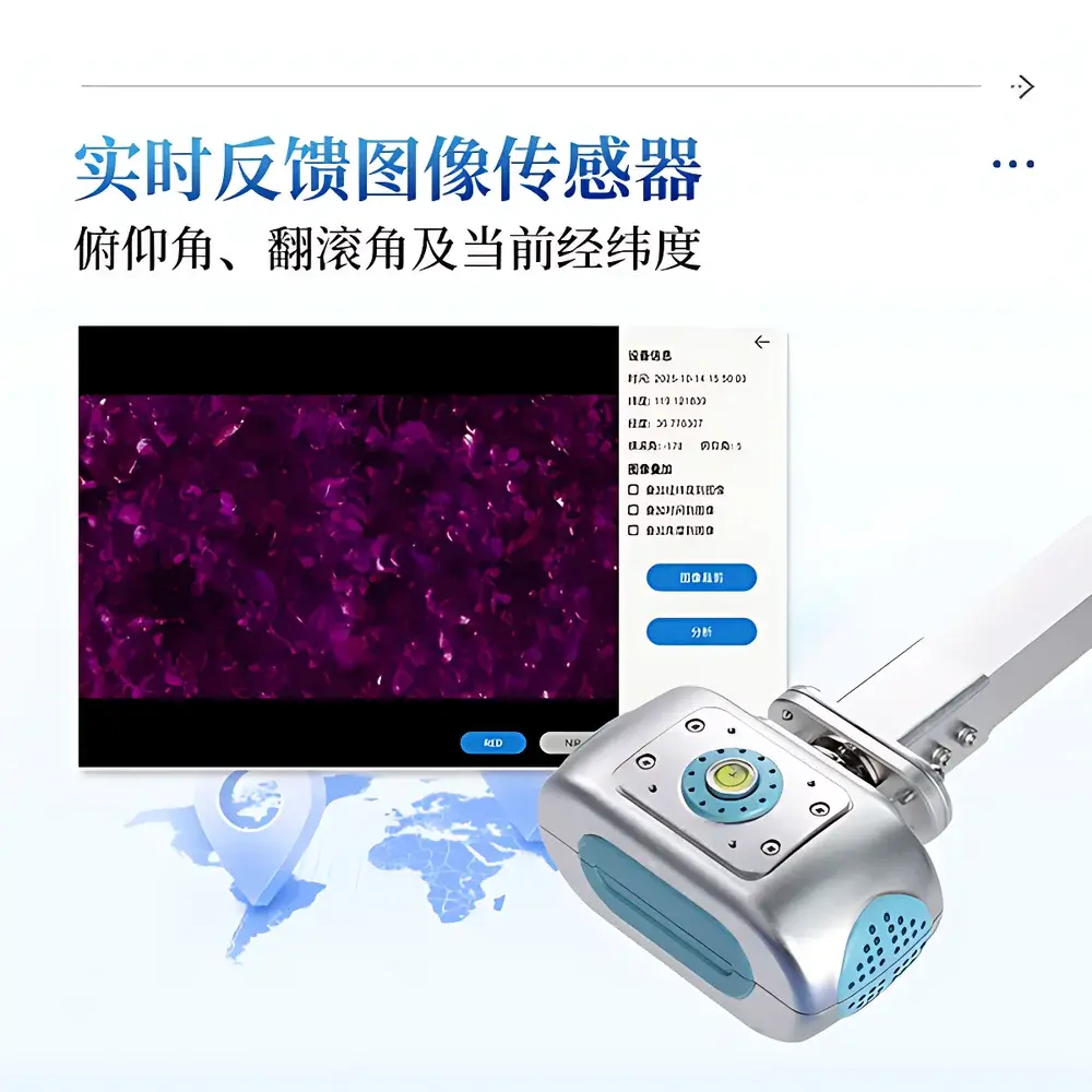
- Integrated 9-axis IMU (roll: 0–360°, pitch: 0–90°) with real-time sensor orientation metadata embedded into image EXIF headers
- 8-inch 700-nit sunlight-readable capacitive touchscreen running Android 12 OS, optimized for glove-compatible field interaction
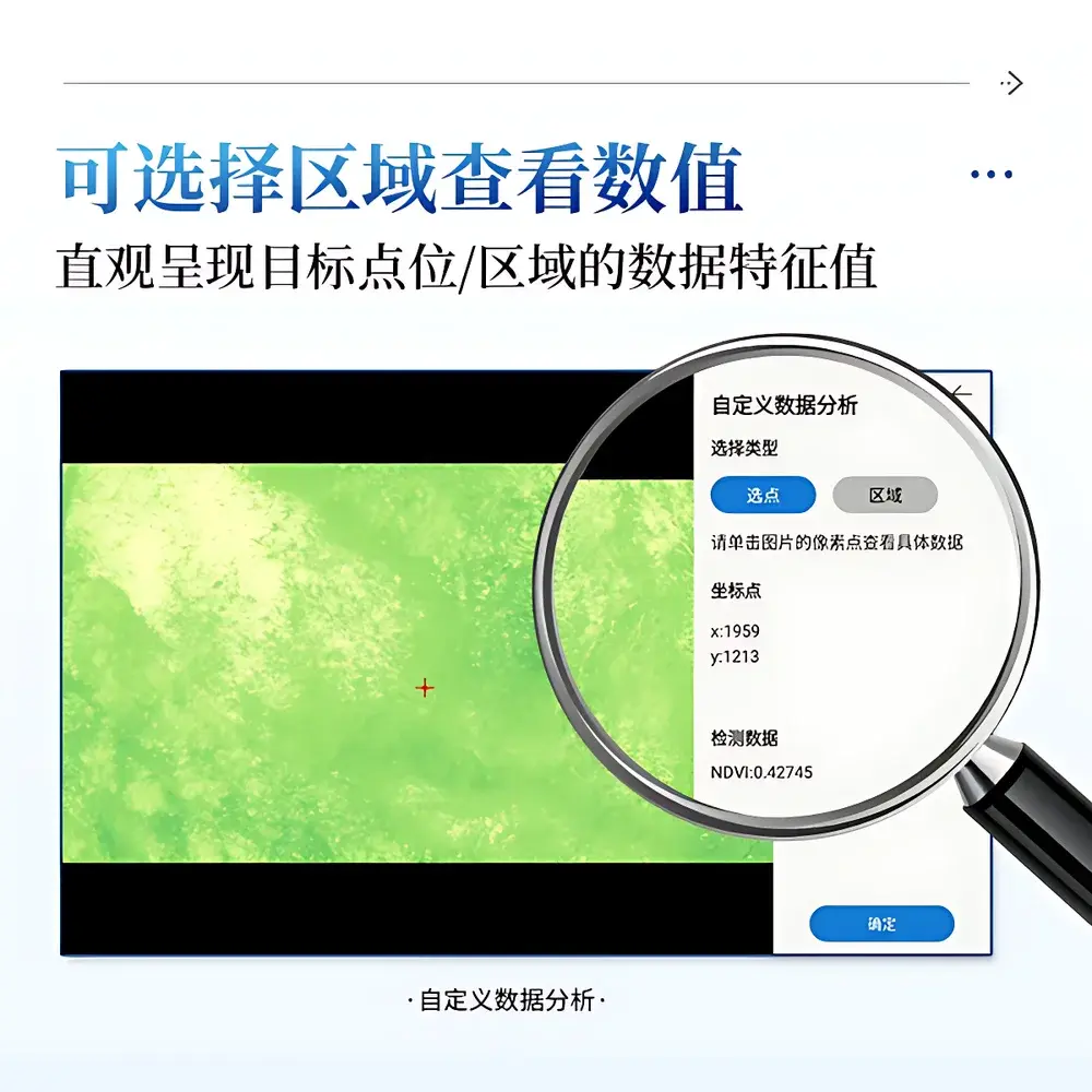
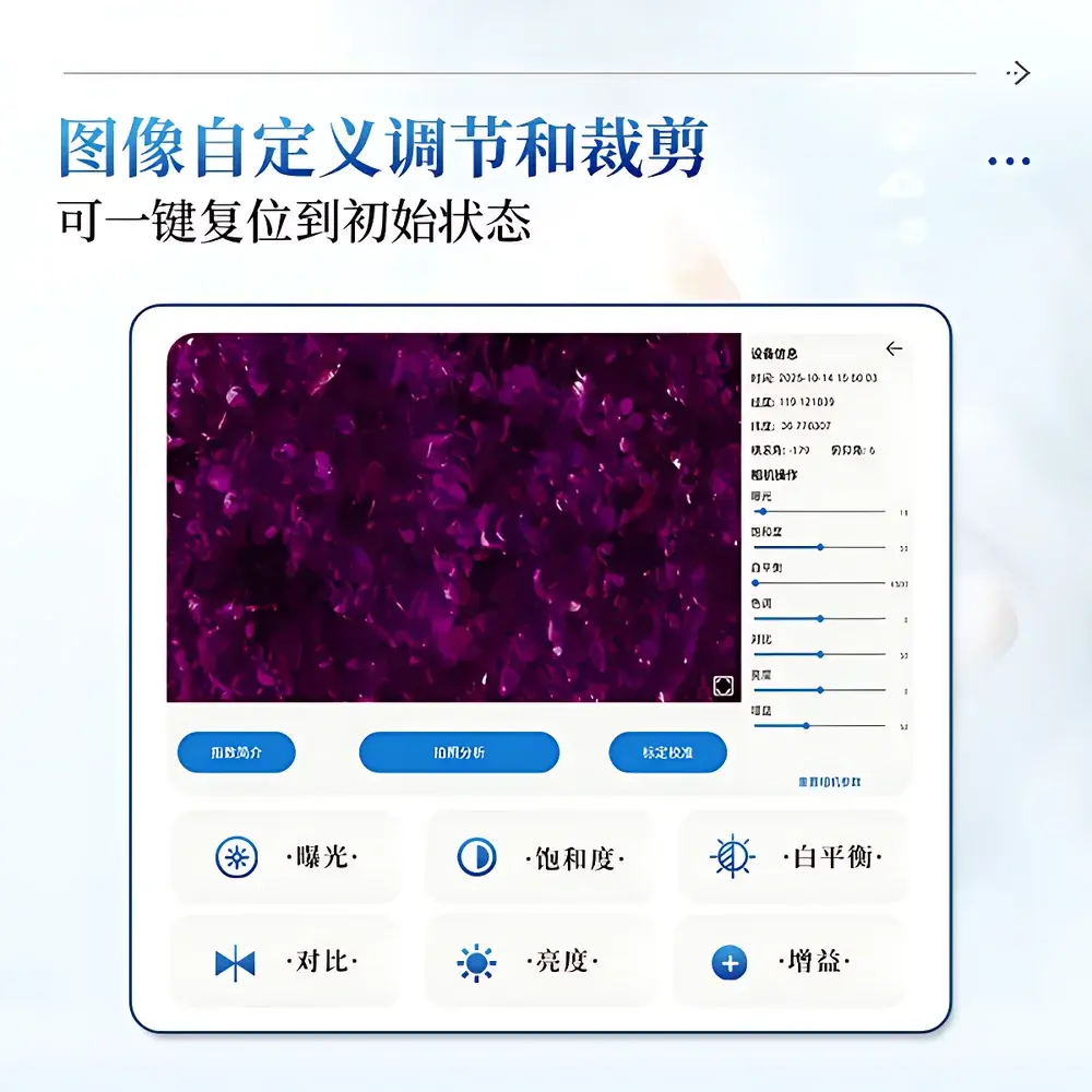
- On-device image processing engine supporting dynamic thresholding, region-of-interest (ROI) masking, and automated pixel classification without cloud dependency
- Field-rugged design: IP54-rated enclosure, operating range −20 °C to +60 °C, 0–95% RH (non-condensing), 3 kg total mass with ergonomic shoulder strap and elbow support
Sample Compatibility & Compliance
The IN-NDVI is validated for use across heterogeneous vegetative surfaces including herbaceous grasslands, row-crop agroecosystems, forest understory plots, and wetland emergent vegetation. Its non-destructive, contactless methodology eliminates sampling bias associated with clipping or destructive LAI measurement. Data outputs comply with FAO’s Agro-Meteorological Data Exchange Format (AMDEF) conventions and support traceability per ISO/IEC 17025:2017 Annex A.2 for field instrumentation calibration documentation. While not FDA 21 CFR Part 11-certified (as it does not perform regulated clinical or pharmaceutical testing), its audit trail features—including timestamped GPS coordinates, operator ID, device serial number, and immutable image hash generation—support GxP-aligned environmental monitoring workflows.
Software & Data Management
The embedded Android application provides real-time index computation, interactive spectral ROI analysis, and configurable export protocols. All raw images, processed indices, and metadata are stored locally on 256 GB internal eMMC storage (with 240 GB user-accessible space), enabling >720 days of continuous logging at standard acquisition intervals. Export formats include CSV (for NDVI, FVC, LAI, GCC, etc.), GeoTIFF (georeferenced pseudocolor maps), and JPEG (annotated thumbnails with overlayed angles and coordinates). Data synchronization occurs via encrypted TLS 1.3 over 4G LTE to the COMECAUSE AgriCloud platform, where users access time-series dashboards, cross-site comparisons, and API-driven integration with third-party GIS or farm management systems (e.g., FarmOS, QGIS, ArcGIS Online). Administrator password protection ensures data integrity during multi-user deployments.
Applications
- High-throughput phenotyping trials: Tracking genotype-by-environment interactions across breeding nurseries using NDVI time series and LAI dynamics
- Precision irrigation scheduling: Correlating canopy-level NDVI gradients with soil moisture sensor networks to optimize water use efficiency
- Carbon sequestration modeling: Estimating aboveground biomass and leaf area density distributions for regional carbon flux parameterization
- Wetland health assessment: Quantifying emergent vegetation cover (FVC) and spectral greenness (GCC) to monitor hydrological regime shifts
- Educational field labs: Teaching spectral remote sensing principles, radiometric calibration, and canopy radiative transfer theory in undergraduate ecology curricula
FAQ
Does the IN-NDVI require external calibration targets for field use?
No. The system employs factory-calibrated spectral response curves and auto-exposure compensation based on incident light intensity; however, optional gray card calibration is supported for high-accuracy comparative studies.
Can the device operate without GPS signal?
Yes. Positional metadata defaults to last-known coordinates with timestamped inertial drift compensation; full GNSS (GPS + BeiDou) is required only for georeferenced mapping exports.
Is raw spectral radiance data accessible for custom index development?
Yes. Raw DN (digital number) values from all three sensors are exportable in 16-bit TIFF format, enabling user-defined vegetation index formulation and radiometric correction workflows.
What is the typical measurement repeatability for NDVI under consistent lighting conditions?
Based on inter-device validation across 12 units (n = 45 repeated measurements per unit), NDVI repeatability is ±0.012 (1σ) within a single day under stable solar zenith angles (±5°).
How is firmware updated and software maintained?
Over-the-air (OTA) updates are delivered via secure HTTPS push through the AgriCloud portal; local USB-based update packages are also provided for offline environments.