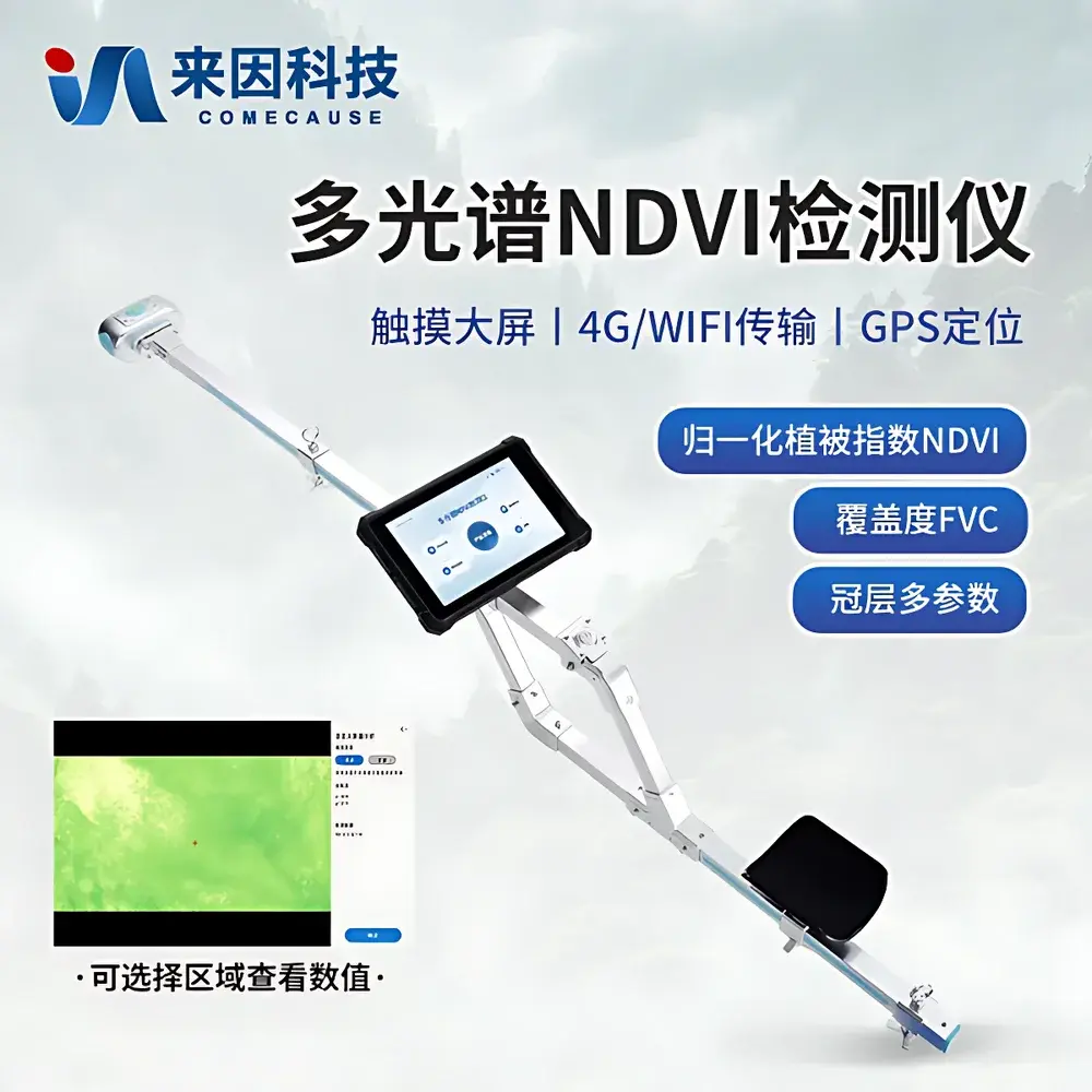
COMECAUSE IN-NDVI Multispectral Canopy Analyzer
| Brand | COMECAUSE |
|---|---|
| Origin | Shandong, China |
| Manufacturer Type | Direct Manufacturer |
| Model | IN-NDVI |
| RGB Sensor | 5 MP CMOS, 80° FOV, true-color output |
| Fisheye Lens | 180° hemispherical FOV for canopy imaging |
| NIR/Red Sensors | 8 MP, dual-band (650 nm ±5 nm red, 850 nm ±5 nm NIR, FWHM 10 nm) |
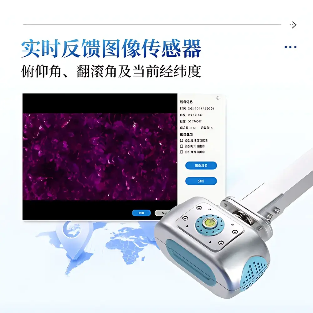
| IMU | Roll 0–360°, Pitch 0–90°, real-time overlay on image |
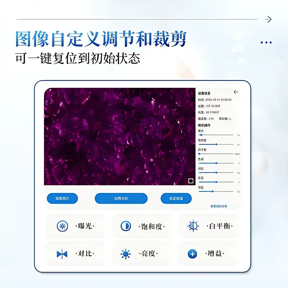
| Image Controls | Adjustable exposure, saturation, white balance, contrast, brightness, gain |
| Display | 8-inch 700-nit outdoor-readable touchscreen |
| Battery | 5550 mAh Li-ion, ~7 h continuous operation |
| Onboard System | Android 12, 16 GB RAM, 256 GB internal storage |
| Connectivity | GPS + BeiDou, 4G LTE, Wi-Fi 5, Bluetooth 5.0 |
| Environmental Rating | -20 °C to +60 °C, 0–95% RH (non-condensing) |
| Weight | 3.0 kg |
| Total Length | ~140 cm |
| Data Export | USB export of raw images, false-color maps, Excel reports, statistical charts |
| Cloud Integration | Secure 4G upload to agri-data cloud platform with user-authenticated access |
| Security | Admin password protection, audit-ready data logging |
| Language | Switchable Chinese/English UI |
Overview
The COMECAUSE IN-NDVI Multispectral Canopy Analyzer is a field-deployable, handheld phenotyping instrument engineered for quantitative vegetation structural and physiological assessment in natural and managed ecosystems. It operates on the principle of multispectral reflectance imaging—capturing synchronized, co-registered red (650 nm) and near-infrared (850 nm) spectral bands alongside high-resolution RGB imagery—to compute radiometrically consistent vegetation indices without requiring external calibration targets under variable illumination. Its dual-acquisition architecture supports both upward-looking (under-canopy) and downward-looking (over-canopy) configurations, enabling rigorous characterization of canopy architecture—including leaf area index (LAI), mean tilt angle (MTA), gap fraction distribution, and directional light transmittance across zenith and azimuthal angles. Designed for reproducible field measurements in grasslands, croplands, wetlands, and forest understories, the system integrates inertial measurement unit (IMU)-stamped orientation metadata directly into image headers, ensuring geometric fidelity for spatially referenced analysis.
Key Features
- Integrated dual-sensor imaging: 5 MP RGB CMOS (80° FOV) and 8 MP monochrome sensors optimized for 650 nm (±5 nm) and 850 nm (±5 nm) bands, with 10 nm full-width half-maximum (FWHM) spectral selectivity.
- 180° fisheye lens for hemispherical canopy photography, supporting angular partitioning of sky-view factors into 10 zenith zones (0–90°) and 10 azimuth sectors (0–360°).
- Real-time IMU fusion: Roll (0–360°), pitch (0–90°), and heading data overlaid on acquired images, enabling georeferenced angular filtering and removal of non-canopy artifacts (e.g., soil gaps, edge effects).
- On-device Android 12 platform with 16 GB RAM and 256 GB eMMC storage—capable of storing >720 days of raw imagery, processed indices, and metadata locally.
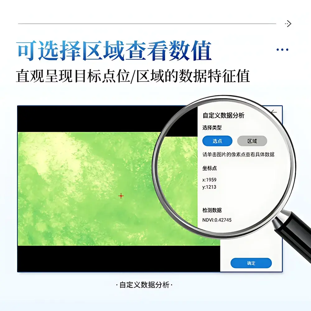
- Field-configurable image processing: Exposure, white balance, contrast, saturation, brightness, and gain adjustments; region-of-interest (ROI) selection via point or polygon; automated threshold optimization to minimize operator bias.
- Ergonomic design: Telescoping 140 cm carbon-fiber pole with shoulder strap and elbow support, reducing operator fatigue during extended transect surveys.
Sample Compatibility & Compliance
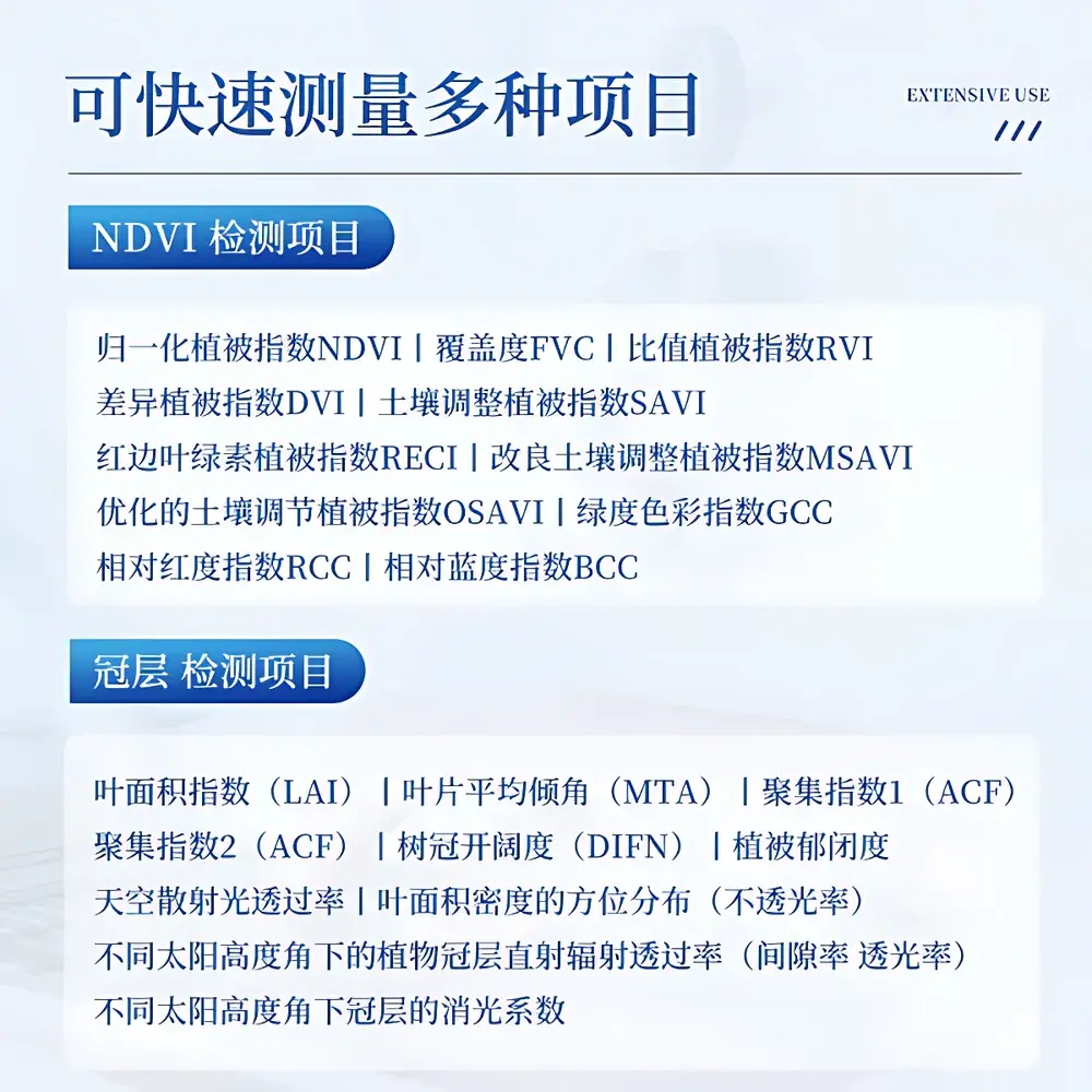
The IN-NDVI is validated for use across diverse vegetation types—including monocot and dicot herbaceous stands, shrub layers, and deciduous/coniferous tree canopies—without sample preparation or destructive sampling. Its optical configuration conforms to ASTM E2623-21 (Standard Practice for Spectral Reflectance Measurements of Vegetation) for passive multispectral field instrumentation. All vegetation index algorithms—including NDVI, SAVI, MSAVI, OSAVI, RECI, GCC, RCC, and BCC—are implemented per peer-reviewed formulations cited in Remote Sensing of Environment and ISPRS Journal of Photogrammetry and Remote Sensing. The device meets IEC 60529 IP54 ingress protection requirements for dust and water resistance, and its operating temperature/humidity range (-20 °C to +60 °C, 0–95% RH non-condensing) aligns with ISO 17025:2017 environmental monitoring equipment specifications. Data integrity protocols comply with GLP principles, including immutable timestamping, operator ID tagging, and encrypted local storage.
Software & Data Management
- Embedded Android application provides real-time NDVI/FVC/LAI visualization, interactive ROI analysis, and false-color mapping using standardized color ramps (e.g., Viridis, Plasma).
- Cloud synchronization via 4G LTE to a secure, ISO/IEC 27001-certified agricultural data platform—supporting role-based access control, versioned dataset archiving, and API-driven integration with GIS and crop modeling tools.
- Export capabilities include: raw TIFF/RAW files, annotated PNG overlays, Excel (.xlsx) summary tables with statistical descriptors (mean, SD, CV%), time-series charts (bar/line), and UTM-projected geoJSON polygons.
- Audit-trail functionality logs all parameter changes, image exports, and admin-level actions—fully traceable for FDA 21 CFR Part 11–aligned workflows where required.
- Bilingual UI (English/Chinese) with one-tap language switching; administrator password lock prevents unauthorized modification of calibration settings or firmware updates.
Applications
The IN-NDVI serves as a primary tool in precision agriculture, ecological monitoring, and plant breeding programs. It enables longitudinal tracking of canopy development dynamics—including early-season vigor assessment, drought stress detection via NDVI temporal derivatives, and post-harvest residue quantification. In rangeland management, it supports objective FVC estimation compliant with UNCCD LDN (Land Degradation Neutrality) reporting standards. For forest ecology, its dual-direction acquisition mode facilitates LAI inversion using gap fraction models (e.g., Beer-Lambert–based or stochastic radiative transfer approaches), while its angular segmentation allows calculation of clumping index (Ω) and diffuse non-interceptance (DIFN). Researchers utilize its high-temporal-resolution datasets to validate satellite-derived vegetation products (e.g., Sentinel-2 L2A, Landsat Collection 2) at plot scale, satisfying FAO’s CropWatch validation protocol requirements.
FAQ
What spectral bands does the IN-NDVI measure, and how are they calibrated?
The instrument captures discrete red (650 nm ±5 nm) and near-infrared (850 nm ±5 nm) bands using interference-filtered CMOS sensors. Factory spectral response curves are stored in device firmware and applied during index computation; no user recalibration is required under standard daylight conditions.
Can the IN-NDVI operate without cloud connectivity?
Yes—full functionality, including image capture, on-device index calculation, and local storage, is available offline. Cloud upload is optional and occurs only when 4G signal is detected and user credentials are authenticated.
How does the system handle mixed-pixel scenes (e.g., soil-vegetation shadows)?
The software applies adaptive thresholding based on local histogram statistics and supports manual masking of non-canopy regions (e.g., bare soil patches, rocks) prior to index derivation—ensuring robustness in heterogeneous landscapes.
Is the device compatible with third-party GIS or statistical software?
All exported data (Excel, GeoJSON, TIFF) adhere to open, non-proprietary formats. Coordinate metadata includes WGS84 latitude/longitude, UTM zone, and altitude from integrated GPS/BeiDou, enabling direct import into QGIS, ArcGIS, R (raster, sf packages), or Python (rasterio, geopandas).
What maintenance is required for long-term field deployment?
No routine optical recalibration is needed. Users should clean lenses with lens-grade tissue and ethanol before each survey; battery health is monitored via onboard diagnostics, and firmware updates are delivered over-the-air or via USB.
Related Products


