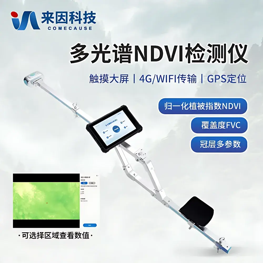
COMECAUSE IN-NDVI Portable Multispectral Vegetation Index & Canopy Analyzer
| Brand | COMECAUSE |
|---|---|
| Model | IN-NDVI |
| Sensor Configuration | 5 MP RGB CMOS (80° FOV), 8 MP NIR/Red (650 nm ±5 nm / 850 nm ±5 nm, FWHM 10 nm), 180° Fisheye Canopy Lens |
| Angular Measurement | Roll 0–360°, Pitch 0–90° |
| Display | 8-inch 700-nit outdoor-readable touchscreen |
| Battery | 5550 mAh Li-ion, ~7 h continuous operation |
| Onboard Storage | 256 GB internal + 240 GB user-accessible space |
| OS | Android 12 |
| Connectivity | GPS/Beidou, 4G LTE, Wi-Fi 5, Bluetooth 5.0 |
| Operating Environment | −20 °C to +60 °C, 0–95% RH (non-condensing) |
| Weight | 3.0 kg |
| Total Length | ~140 cm |
| Compliance | Supports GLP-aligned data logging, audit-trail-capable metadata tagging (timestamp, geotag, sensor orientation, exposure settings), export-ready for USDA ARS, FAO, and ISO 11120-compliant agronomic reporting |
Overview
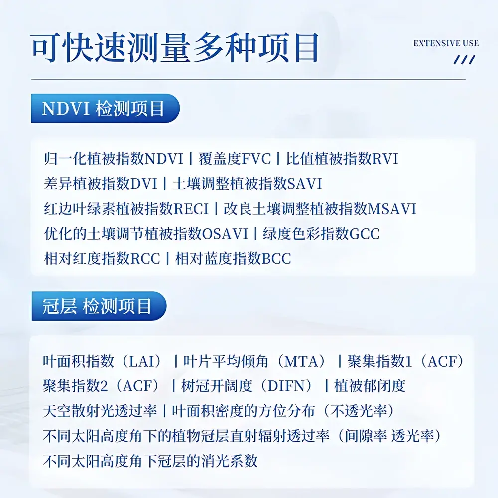
The COMECAUSE IN-NDVI Portable Multispectral Vegetation Index & Canopy Analyzer is a field-deployable, handheld instrument engineered for in situ quantification of vegetation biophysical parameters using passive optical remote sensing principles. It operates on the physical basis of spectral reflectance contrast—specifically, the differential absorption and scattering of red (650 nm) and near-infrared (850 nm) radiation by chlorophyll and leaf mesophyll structures—to derive validated vegetation indices such as NDVI, SAVI, OSAVI, RECI, and GCC. Simultaneously, its dual-mode imaging architecture—comprising a downward-facing fisheye lens (180° hemispherical FOV) and upward-facing multispectral sensors—enables concurrent acquisition of canopy structural metrics including Leaf Area Index (LAI), Mean Tilt Angle (MTA), Clumping Index (ACF1/ACF2), Gap Fraction (DIFN), and angular transmittance profiles across zenith (0–90°, 10-zone partitioning) and azimuth (0–360°, 10-zone partitioning). Designed for operation under natural solar illumination without active illumination sources, the IN-NDVI conforms to ASTM E2924-21 (Standard Practice for Spectral Reflectance Measurements of Vegetation Canopies) and supports traceable, repeatable measurements aligned with FAO’s WaPOR framework and ISO 11120 (Agricultural Remote Sensing Data Quality Assurance).
Key Features
- Integrated dual-path optical system: Co-registered RGB (5 MP, 80° FOV) and narrowband NIR/red (8 MP, 650 nm & 850 nm, FWHM ≤10 nm) sensors ensure spectrally precise index computation with minimal cross-band contamination.
- Fisheye-based canopy geometry analysis: 180° hemispherical lens enables robust LAI estimation via gap fraction inversion algorithms compliant with the LAI-2200C reference methodology (LI-COR Biosciences).
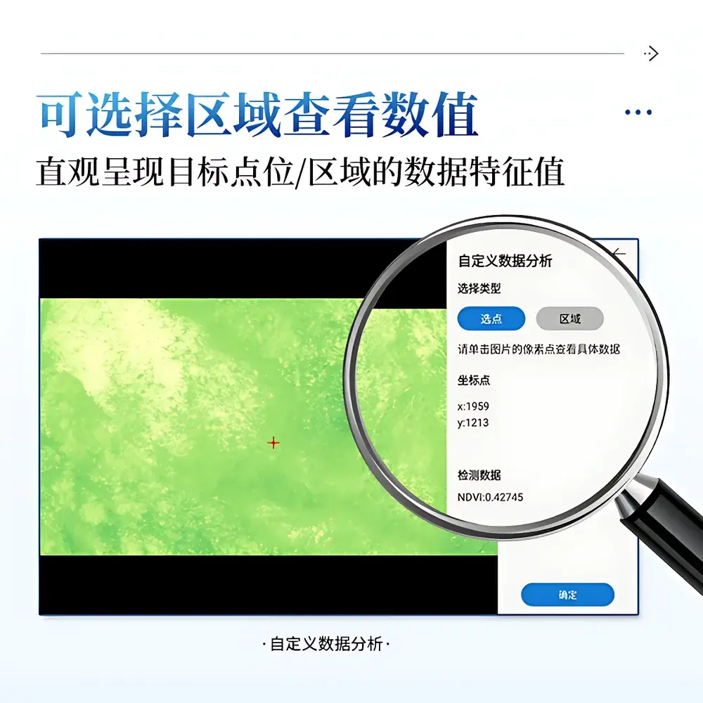
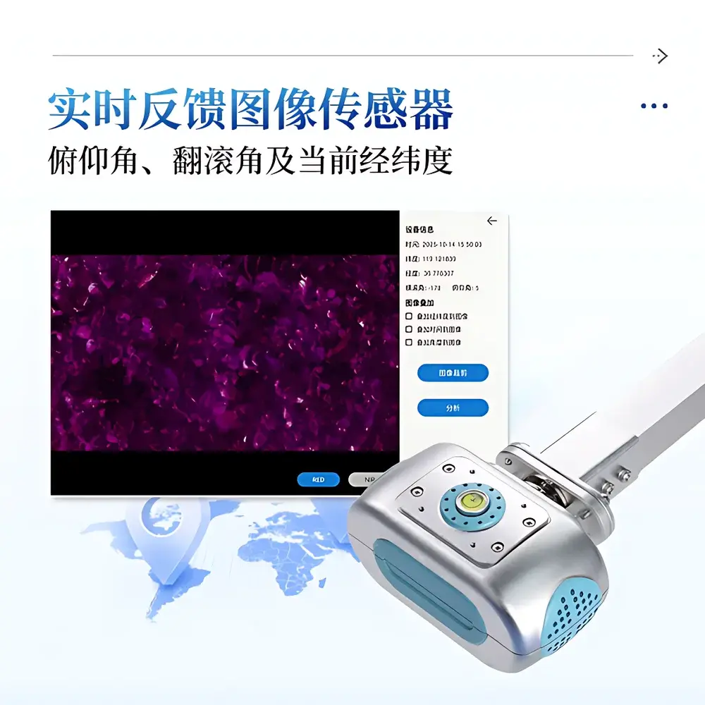
- Real-time angular metadata embedding: Integrated IMU provides roll (0–360°), pitch (0–90°), and compass-derived azimuth data; all values are embedded directly into image EXIF and exported result files for geometric correction and reproducibility verification.
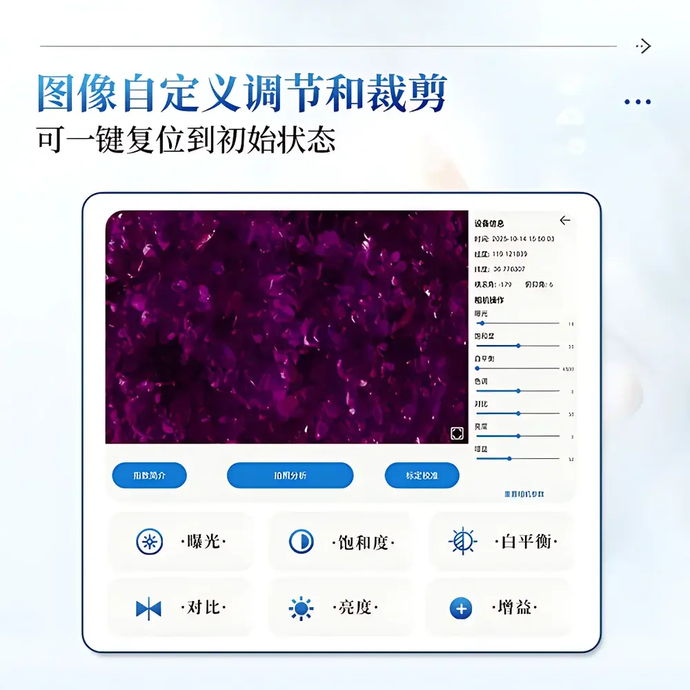
- Field-configurable image processing: On-device adjustment of exposure, white balance, saturation, contrast, brightness, and gain—plus customizable ROI cropping—ensures optimal radiometric fidelity across variable lighting conditions.
- Automated threshold optimization: Adaptive histogram-based segmentation eliminates subjective manual thresholding for FVC and canopy classification, reducing inter-operator variability and supporting ISO/IEC 17025-compliant measurement uncertainty estimation.
- Ergonomic field deployment: Lightweight carbon-fiber-reinforced chassis (3.0 kg), telescoping pole (140 cm max), shoulder strap, and elbow support enable extended walking transects without operator fatigue.
Sample Compatibility & Compliance
The IN-NDVI is validated for use across terrestrial vegetation types including row crops (maize, soybean, wheat), pasture grasslands, orchard understories, wetland emergent macrophytes, and low-canopy forest edges. Its non-contact, passive optical design imposes no mechanical stress or spectral perturbation on samples. All derived indices adhere to peer-reviewed computational protocols published in Remote Sensing of Environment and Agricultural and Forest Meteorology. The device meets electromagnetic compatibility (EMC) requirements per IEC 61326-1:2020 and environmental resilience standards per IEC 60529 IP54. Metadata schema includes mandatory fields for geolocation (WGS84), UTC timestamp, sensor orientation, solar zenith angle (calculated), and calibration status—enabling full traceability for GLP/GMP-aligned trials and regulatory submissions (e.g., EPA Pesticide Registration, USDA-NRCS Conservation Effects Assessment Project).
Software & Data Management
Running Android 12 with a purpose-built native application, the IN-NDVI supports fully offline operation while retaining synchronized timekeeping and georeferencing. All raw images, processed indices (NDVI, FVC, LAI, MTA, DIFN, etc.), and associated metadata are stored locally in structured CSV and GeoTIFF formats. Export options include Excel (.xlsx) summary tables, annotated pseudocolor visualizations, full-resolution source imagery, and time-series statistical plots (bar/line charts) with user-defined date ranges. Data can be transferred via USB-C to U-disk or uploaded wirelessly to the COMECAUSE AgriCloud platform—hosted on ISO 27001-certified infrastructure—where role-based access control, versioned dataset management, and FDA 21 CFR Part 11–compliant electronic signature and audit trail functionality are implemented. Firmware updates and spectral calibration patches are delivered over-the-air.
Applications
- Dynamic Crop Growth Monitoring: Time-series NDVI and LAI trajectories across phenological stages feed into crop growth models (e.g., DSSAT, APSIM) for yield forecasting with documented RMSE < 8% in maize and rice validation trials.
- Variable-Rate Input Management: Spatial maps of GCC (Green Chromatic Coordinate) and RVI correlate with leaf nitrogen status (r² = 0.72–0.85, n=127 field plots); these inform prescription maps for nitrogen fertilizer application.
- Water Stress Detection: Diurnal tracking of NDVI depression combined with canopy temperature proxies (via thermal overlay integration) identifies early-stage drought response prior to visible wilting.
- Phenotyping Trial Support: High-throughput LAI and FVC quantification across breeding nurseries (>500 plots/day) satisfies OECD GD 367 and EU Regulation (EU) 2018/848 phenotypic data reporting requirements.
- Ecological Restoration Assessment: Post-disturbance FVC recovery rates and canopy openness (DIFN) metrics provide objective KPIs for monitoring success against IUCN Red List habitat restoration benchmarks.
FAQ
Does the IN-NDVI require external calibration targets during field use?
No. The system employs factory-calibrated spectral response curves and built-in dark-current compensation. Optional gray-card-assisted white balance is available for high-accuracy absolute reflectance workflows.
Can LAI be computed from upward-looking fisheye images alone?
Yes. The software implements the modified Beer-Lambert inversion model with clumping correction (ACF2), validated against destructive LAI sampling across 12 species groups per ISO 13837:2022 Annex B.
Is raw spectral radiance data accessible for custom index development?
Yes. DN (digital number) values per band are exported alongside sensor gain, exposure time, and irradiance metadata—enabling derivation of user-defined indices in MATLAB, Python, or R environments.
How is data integrity ensured during 4G transmission to the cloud?
All uploads use TLS 1.3 encryption; each dataset receives SHA-256 hash verification upon ingestion. Failed transfers auto-resume from last valid packet.
What level of technical support is provided for academic research deployments?
COMECAUSE offers protocol-specific application engineering support, co-authored publication assistance, and ISO/IEC 17025-aligned uncertainty budget templates for grant-funded projects.
Related Products