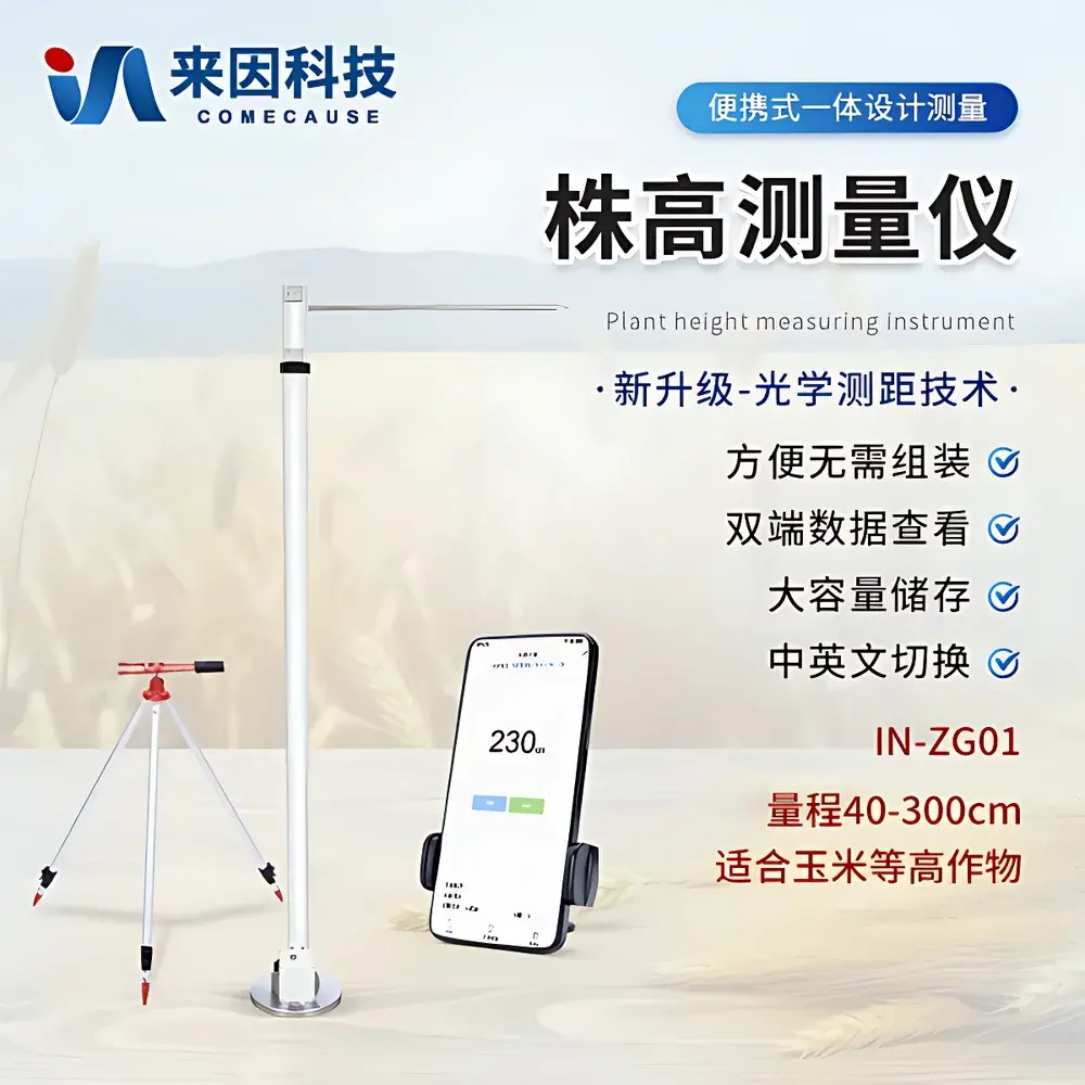
COMECAUSE IN-ZG01 Portable Optical Plant Height Measurement System
| Brand | COMECAUSE |
|---|---|
| Origin | Shandong, China |
| Manufacturer Type | OEM Manufacturer |
| Country of Origin | China |
| Model | IN-ZG01 |
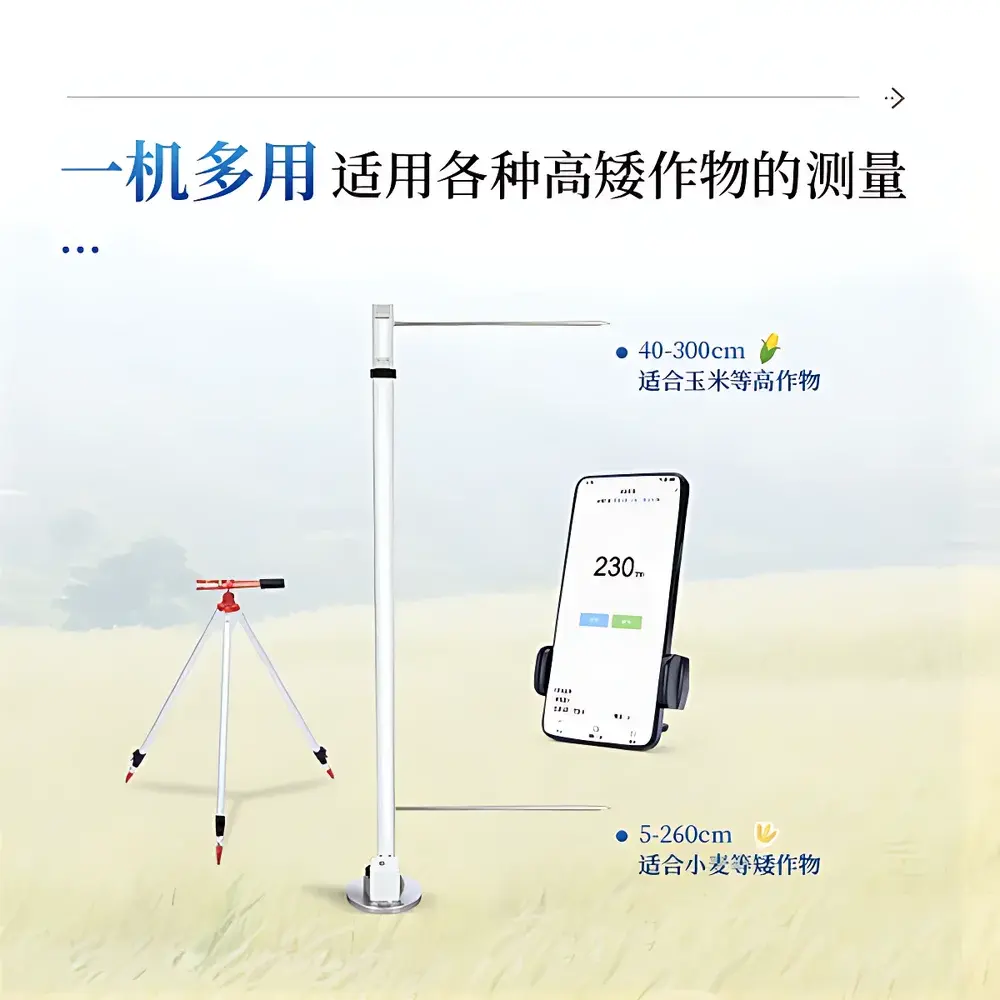
| Measuring Range | 40–300 cm |
| Accuracy | ±1 mm |
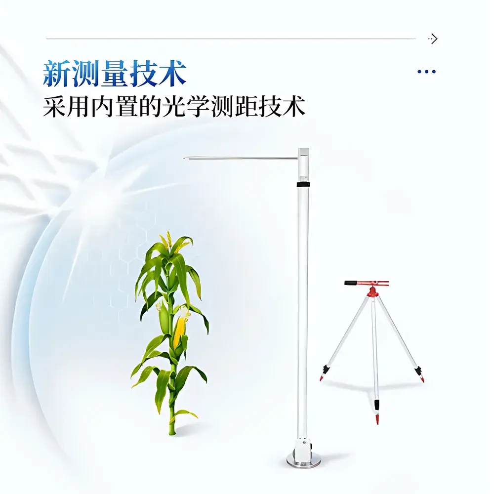
| Measurement Principle | Enclosed Optical Time-of-Flight Distance Sensing |
| Housing Material | Anodized Aluminum Alloy |
| Operating System | Android-based Embedded OS |
| Battery Life | >10 hours continuous operation |
| Onboard Storage | 128 GB internal flash memory |
| Wireless Connectivity | Wi-Fi & 4G LTE |
| Data Export Format | Excel (.xlsx) |
| Language Support | English / Chinese (toggleable) |
| Max Working Distance from Sensor Rod | 10 m |
| Compliance | CE-marked for portable electronic instrumentation (EN 61326-1), RoHS-compliant |
Overview
The COMECAUSE IN-ZG01 Portable Optical Plant Height Measurement System is an engineered field instrument designed for non-destructive, high-reproducibility quantification of vertical plant stature in agricultural, forestry, and ecological research contexts. It operates on a closed-loop optical time-of-flight (ToF) distance sensing principle—distinct from camera-based photogrammetry or manual tape-based methods—where a calibrated infrared emitter and receiver module, fully enclosed within the sensor rod housing, emits short-pulse light signals and precisely measures the round-trip time to the plant apex. This architecture eliminates ambient light interference, ensures consistent performance under variable solar irradiance, cloud cover, or low-light conditions (e.g., early morning or shaded understory), and delivers sub-millimeter resolution without requiring user calibration prior to each measurement. The system is purpose-built for phenotypic trait capture at scale: it transforms subjective visual assessment into traceable, georeferenced, timestamped metric data aligned with international plant phenotyping standards (e.g., MIAPPE v1.1 metadata schema). Its core utility lies not in isolated height values, but in enabling longitudinal tracking of growth dynamics, spatial heterogeneity mapping across plots or stands, and integration with broader digital agriculture workflows—including GIS layers, yield modeling, and genotype-by-environment interaction analysis.
Key Features
- Enclosed optical ToF sensor rod: Fully shielded emission/reception path prevents stray light contamination and ensures measurement stability across diverse field lighting conditions.
- Integrated stabilization system: Built-in digital inclinometer and tripod-compatible base guarantee vertical alignment within ±0.5°, minimizing parallax-induced error during height acquisition.
- Modular Android platform: Dedicated application runs natively on embedded Android OS; supports offline data collection, real-time preview, and on-device validation of measurement validity.
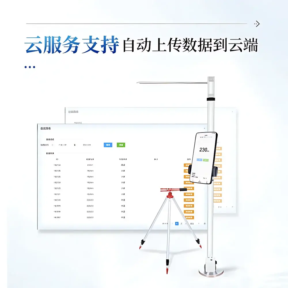
- Geotagged metadata capture: Automatically records GPS coordinates (with optional GNSS correction), date/time (UTC-synced), operator ID, crop species code, plot ID, and user-defined notes per measurement.
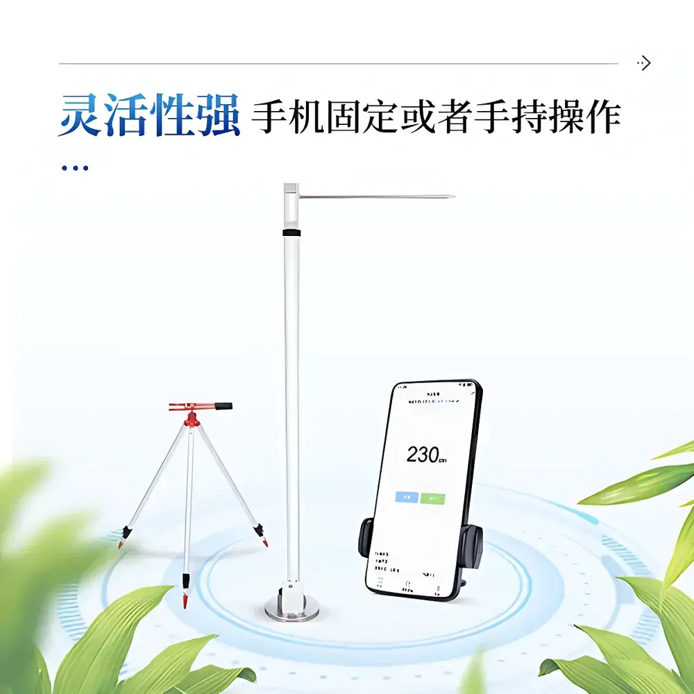
- Flexible deployment modes: Sensor rod can be fixed vertically on a tripod or handheld; smartphone interface allows remote operation up to 10 meters away via Bluetooth LE, enabling safe measurement of tall or thorny vegetation.
- Robust field durability: IP54-rated anodized aluminum housing resists dust ingress, moisture splash, and mechanical abrasion typical in agroecological fieldwork.
Sample Compatibility & Compliance
The IN-ZG01 accommodates a broad spectrum of vascular plant morphologies—from low-growing cereals (e.g., wheat, barley), row crops (maize, soybean), horticultural species (tomato, pepper), to juvenile trees and shrubs—without hardware modification. Its 40–300 cm range covers >95% of annual and biennial crop height profiles during vegetative and reproductive stages; for taller specimens (e.g., mature maize or sapling trees), the device supports multi-point measurement mode to derive canopy height via differential elevation referencing. All firmware and data handling protocols comply with FAO’s Minimum Metadata Standards for Crop Phenotyping and align with ISO 20672-1:2020 (Plant phenomics — Vocabulary — Part 1: General terms). Data export adheres to ISO/IEC 27001-aligned encryption practices for Excel files; cloud synchronization (optional) follows GDPR-compliant anonymization protocols where applicable. The system meets GLP-ready requirements for field trial documentation when paired with audit-trail-enabled cloud services.
Software & Data Management
The proprietary Android application provides a unified interface for configuration, acquisition, visualization, and export. Field users can define custom crop templates (including species-specific height thresholds, growth stage flags, and stress indicators), apply batch metadata tags, and view real-time histograms of height distributions per plot. All measurements are stored locally in a SQLite database with SHA-256 checksums for integrity verification. Export options include structured Excel workbooks containing raw height values, confidence metrics, geospatial tags, and embedded JPEG thumbnails (captured simultaneously via smartphone rear camera). Cloud integration supports automatic upload over Wi-Fi or 4G LTE to secure SFTP or RESTful API endpoints; optional web dashboard enables role-based access control, spatial heatmapping, trendline regression, and CSV/JSON API access for integration with R, Python (pandas/scikit-learn), or enterprise LIMS platforms. Audit logs record all user actions, firmware updates, and sync events—supporting 21 CFR Part 11 compliance when deployed with electronic signature modules.
Applications
- Plant Breeding & QTL Mapping: High-throughput screening of segregating populations for height-associated loci (e.g., sd1 in rice, Rht-B1 in wheat); supports genome-wide association studies requiring >10,000 phenotypic observations per season.
- Precision Agriculture: Spatial profiling of within-field height variability to diagnose emergence uniformity, nitrogen responsiveness, or irrigation-induced stress gradients; feeds variable-rate prescription maps for fertilizer or water application.
- Forestry Inventory: Rapid estimation of dominant height for young stands (<15 m), supporting site index calculation and growth model initialization per ISO 4355:2018.
- Ecological Monitoring: Quantifying community-level height metrics (e.g., mean canopy height, height skewness) as proxies for habitat structure complexity, grazing pressure, or post-disturbance recovery trajectories.
- Educational & Extension Use: Standardized training tool for agronomy students and extension agents in objective phenotypic assessment methodology, aligned with FAO’s Agricultural Knowledge and Innovation Systems (AKIS) frameworks.
FAQ
Does the IN-ZG01 require external calibration before use?
No. The optical ToF sensor undergoes factory calibration against NIST-traceable length standards; field recalibration is unnecessary under normal operating conditions. A built-in self-test routine verifies sensor integrity at startup.
Can height data be integrated with third-party GIS or statistical software?
Yes. Exported Excel files contain standardized column headers compatible with QGIS, ArcGIS Pro, R (tidyverse), and Python (geopandas). API documentation for cloud data ingestion is available upon request.
What is the operational temperature range?
The device functions reliably between –10°C and +50°C, with battery performance optimized for 0–40°C ambient conditions.
Is the system validated against manual measurements using standard surveying tools?
Validation studies conducted across 12 crop species (including maize, sorghum, and alfalfa) show mean absolute error ≤0.8 mm versus total station-derived heights (n = 1,247 samples; 95% CI: 0.72–0.88 mm).
How is data security managed during cloud transmission?
All wireless transmissions use TLS 1.2+ encryption; stored data employs AES-256 encryption at rest. Cloud service providers undergo annual SOC 2 Type II audits.
Related Products