Ecodrone UAS-4 Pro Integrated Multispectral-LiDAR UAV Remote Sensing System
| Origin | Beijing, China |
|---|---|
| Manufacturer Type | Authorized Distributor |
| Origin Category | Domestic (China) |
| Model | Ecodrone UAS-4 Pro |
| Pricing | Available Upon Request |
Overview
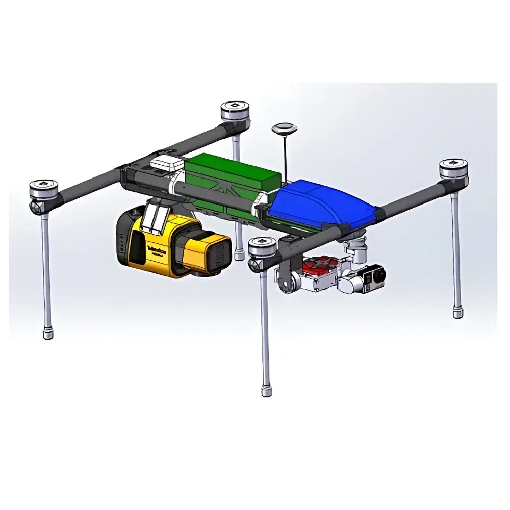
The Ecodrone® UAS-4 Pro Integrated Multispectral–LiDAR UAV Remote Sensing System is an engineered platform for high-resolution, multi-modal ecological and agricultural remote sensing. Designed around a proprietary quadcopter unmanned aerial system (UAS), it integrates synchronized multispectral imaging, time-of-flight (ToF) LiDAR, and high-fidelity RGB acquisition into a single, field-deployable unit. The system operates on the principle of active–passive remote sensing synergy: LiDAR delivers precise 3D structural metrics via laser pulse return timing and intensity, while multispectral sensors capture reflectance signatures across discrete spectral bands to derive biophysical and biochemical vegetation indices. This dual-modality architecture enables simultaneous quantification of canopy geometry (e.g., height, density, vertical profile) and spectral physiology (e.g., chlorophyll content, water status, red-edge slope), supporting rigorous, non-destructive phenotyping and ecosystem monitoring under GLP-aligned field protocols.
Key Features
- Integrated sensor payload: Co-aligned 10-band multispectral imager (5–10 configurable bands, including NIR, Red Edge, and SWIR-capable variants), 3-return LiDAR with ±2.5 cm vertical accuracy, and Sony APS-C Exmor CMOS RGB camera (20 MP, 83° FOV)
- High-efficiency flight operation: >20 minutes endurance per battery cycle; optimized for low-altitude (<50 m) surveys with ground sampling distances (GSD) down to 2.0 cm at 30 m AGL and 3.4 cm at 50 m AGL
- Hardware-synchronized data acquisition: All sensors triggered via common GPS/IMU timestamping, ensuring sub-pixel spatial registration between point cloud, multispectral raster, and RGB orthomosaic outputs
- Robust UAS-4 platform: Carbon-fiber airframe with redundant IMU/GNSS, IP43 environmental rating, and automated mission planning compatible with RTK-GNSS base stations for centimeter-level georeferencing
- Field-calibrated radiometric workflow: Includes onboard irradiance sensor, reflectance panel integration, and dark-frame correction for quantitative reflectance conversion (Lλ → ρλ) compliant with ISO 19130-2 and ASTM E2762 standards
Sample Compatibility & Compliance
The UAS-4 Pro is validated for use in open-field, forested, and semi-arid terrestrial ecosystems. It supports repeatable, transect-based survey designs aligned with FAO’s CropWatch framework and IPCC Tier 2 biomass estimation guidelines. Data products—including classified point clouds (ground/non-ground), digital surface models (DSM), digital terrain models (DTM), digital height models (DHM), normalized difference vegetation index (NDVI), normalized difference red edge (NDRE), green chlorophyll index (GCI), leaf chlorophyll index (LCI), and plant area index (PAI)—are structured to meet metadata requirements of ISO 19115-2 and comply with USGS Level 2 processing standards. The system’s LiDAR point density (>200 pts/m² at 30 m altitude) and multispectral band positioning conform to USDA ARS protocol benchmarks for crop phenotyping and are suitable for audit-ready documentation under GLP and GMP-aligned research environments.
Software & Data Management
- Pre-installed Ecodrone® FlightControl v4.2: Mission planner with no-fly zone enforcement, automated grid/waypoint routing, and real-time telemetry overlay
- Ecodrone® ProcessSuite: Modular post-processing suite supporting radiometric calibration, point cloud classification (ground, vegetation, stem), DSM/DTM generation, orthorectified mosaic stitching, and pixel-wise vegetation index computation
- Export compatibility: GeoTIFF, LAS/LAZ, CSV, ENVI .hdr, and OGC-compliant WMS/WFS endpoints; supports direct ingestion into ArcGIS Pro, QGIS, ENVI, and MATLAB via GDAL/OGR drivers
- Audit-ready data traceability: Full logging of sensor configuration, GPS timestamps, IMU orientation quaternions, and radiometric calibration coefficients—enabling full reproducibility and alignment with FDA 21 CFR Part 11 electronic record requirements
Applications
The UAS-4 Pro serves as a primary remote sensing tool across multiple domains requiring spatiotemporally resolved structural–spectral characterization. In precision agriculture, it enables high-throughput phenotyping for varietal screening, nitrogen use efficiency modeling, and yield forecasting through coupled PAI–NDRE regression frameworks. In forestry and carbon cycle science, its LiDAR-derived canopy height models (CHM) and multi-temporal NDWI time series support aboveground biomass (AGB) estimation, carbon stock change detection, and flux partitioning analysis per ICOS and FLUXNET protocols. For biodiversity and habitat assessment, the system delivers stratified vegetation structure maps usable in species distribution modeling (SDM) and landscape fragmentation analysis. Additional validated use cases include irrigation scheduling via thermal–multispectral fusion (when paired with optional thermal module), early stress detection in vineyards using red-edge slope metrics, and wetland hydroperiod mapping via NDWI–DSM integration.
FAQ
What spectral bands are standard on the 10-channel multispectral sensor?
The default configuration includes 480 nm (blue), 550 nm (green), 660 nm (red), 730 nm (red edge), and 840 nm (NIR), with five additional bands selectable from a library spanning 400–1000 nm, including 530 nm, 570 nm, 610 nm, 680 nm, and 900 nm.
Is the LiDAR system capable of penetrating dense canopy layers?
Yes—the triple-return capability enables partial penetration of upper foliage layers, allowing separation of canopy top, mid-canopy, and ground returns; classification algorithms support extraction of understory vegetation metrics where applicable.
Can raw LiDAR point clouds be exported in industry-standard formats?
Yes—LAS 1.4 and LAZ (compressed LAS) formats are natively supported, including full preservation of intensity, return number, scan angle, and GPS time fields.
Does the system support automated flight over irregularly shaped fields?
Yes—FlightControl software accepts KML/KMZ boundary imports and generates adaptive grid patterns that conform to complex polygon geometries while maintaining consistent GSD and overlap parameters.
Are calibration certificates provided for radiometric and geometric accuracy verification?
Each unit ships with a factory calibration report documenting multispectral sensor spectral response curves, LiDAR ranging accuracy under controlled conditions, and IMU/GNSS alignment tolerances; on-site validation kits (reflectance panels, GNSS base station logs) are available upon request.
Related Products