EcoTech PheoPlot® Portable Plant Phenotyping Imaging System
| Brand | EcoTech |
|---|---|
| Origin | Beijing, China |
| Model | PheoPlot® Portable |
| Spectral Range (Standard) | 400–1000 nm (448 bands, F/1.7, 1024-pixel spatial resolution, SNR ≥ 400:1, 330 FPS full-frame) |
| Spectral Range (Optional) | 900–1700 nm (224 bands, F/1.7, 640-pixel spatial resolution, SNR ≥ 1000:1, 670 FPS full-frame) |
| Thermal Imaging | 640 × 512 IR resolution, −20 °C to +150 °C |
| RGB Imaging | 20 MP |
| Platform Span | 1.5 m (standard), up to 2.0 m (optional) |
| Height Adjustment | 50–160 cm |
| Positioning Accuracy | <1 mm |
| Battery Life | >8 h (dual Li-ion, parallel configuration) |
| Software | Embedded Linux OS + Windows PC GUI with protocol scripting (up to 10 automated sequences) |
| Compliance | Designed for GLP-aligned field phenotyping workflows |
Overview
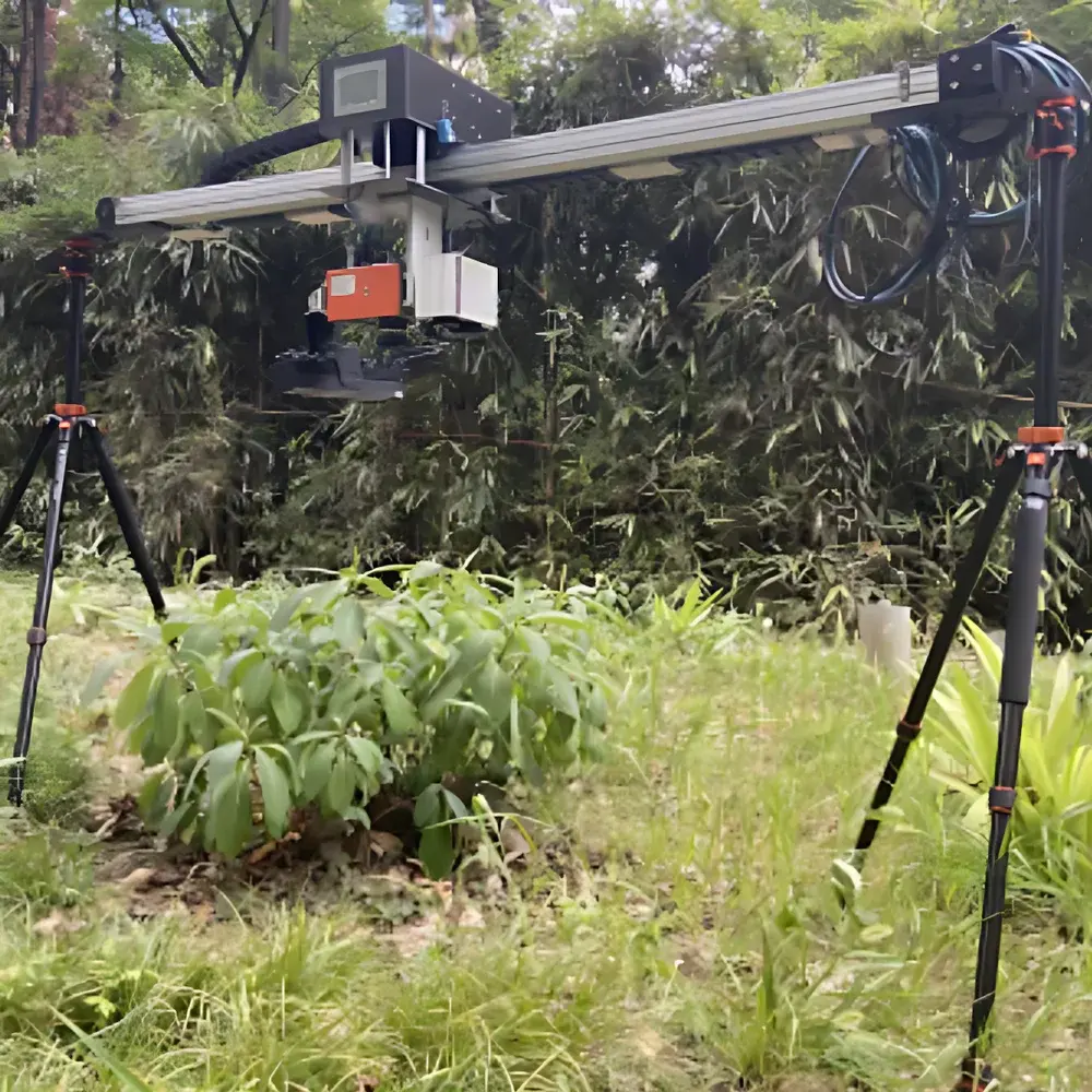
The EcoTech PheoPlot® Portable Plant Phenotyping Imaging System is an integrated, ground-based, in-situ phenotyping platform engineered for high-resolution, multi-modal optical sensing of plant structure, physiology, and environmental interaction under natural field conditions. Built upon EcoTech’s patented near-ground remote sensing architecture (ZL 2020 2 2019108.9), the system combines modular mechanical design with synchronized multispectral, fluorescence, thermal, and RGB imaging capabilities—enabling quantitative, non-destructive measurement of dynamic phenotypic traits across spatial and temporal scales. Its core measurement principles include hyperspectral reflectance analysis (400–1000 nm and optional 900–1700 nm), solar-induced chlorophyll fluorescence (SIF) retrieval via spectral unmixing, LED-induced fluorescence (LEDIF) kinetics at canopy scale, thermo-RGB fusion for stomatal conductance inference, and UV-MCF (ultraviolet-modulated chlorophyll fluorescence) for photoprotective pigment mapping. The system operates independently of laboratory infrastructure, supporting both diurnal and nocturnal acquisition cycles while maintaining sub-millimeter positional repeatability—critical for longitudinal monitoring of plot-level responses to abiotic or biotic stressors.
Key Features
- Modular, foldable, and lightweight mechanical frame (1.5 m standard X-axis span; height adjustable from 50–160 cm), enabling rapid deployment across heterogeneous field plots, iPOT microcosms, or miniPlot experimental units.
- Dual-mode hyperspectral imaging: Standard 400–1000 nm sensor (448 bands, F/1.7, 1024-pixel linear array, 330 FPS full-frame, SNR ≥ 400:1) and optional 900–1700 nm module (224 bands, 640-pixel array, 670 FPS, SNR ≥ 1000:1), both supporting user-defined band selection and real-time spectral binning.
- Integrated LEDIF fluorescence imaging unit with spectral-resolved detection (e.g., F685/F740, F735/F700, F730–740/F680–690), enabling quantitative assessment of photosynthetic efficiency, chronic stress status, and chlorophyll content without external actinic light interference.
- Thermo-RGB fused imaging subsystem: Co-registered 20 MP RGB and 640 × 512 IR sensors (−20 °C to +150 °C range), supporting ROI-based temperature statistics (min/max/mean/delta), morphometric analysis (length, width, convex hull area, circularity), and color-space quantification (RGB, HSV, greenness index).
- Embedded Linux OS with 7-inch capacitive touchscreen (Chinese UI) and companion Windows-based desktop software for protocol definition (up to 10 programmable sequences), georeferenced data logging, and batch processing.
- Onboard GNSS receiver, ambient temperature/humidity/illuminance sensors, and position memory function (<1 mm repeatable positioning) for traceable, context-aware data capture aligned with FAO and IPCC field metadata standards.
- Dual lithium-ion battery pack delivering >8 hours continuous operation in mixed-sensor mode; supports hot-swappable power management for extended campaigns.
Sample Compatibility & Compliance
The PheoPlot® Portable system is validated for use with herbaceous and woody species grown in open-field plots, controlled-environment mesocosms (e.g., Soiltron®-based iPOT systems), greenhouse trays, and lysimeter-based setups. It accommodates variable canopy heights (up to 150 cm), row spacings (≥30 cm), and soil surface heterogeneity through adaptive height calibration and terrain-following scanning logic. All optical modules comply with IEC 62471 (photobiological safety) and CE electromagnetic compatibility directives. Data acquisition workflows support audit-ready metadata tagging per ISO/IEC 17025 requirements, including timestamp, GNSS coordinates, sensor calibration IDs, and environmental context. While not a regulated medical device, its analytical outputs—including NDVI, PSRI, SIF yield, and canopy temperature differentials—are referenced in peer-reviewed protocols for USDA ARS drought phenotyping, EU H2020 AgriPheno initiatives, and FAO crop water productivity modeling frameworks.
Software & Data Management
Data acquisition and post-processing are managed via EcoTech’s proprietary PheoStudio™ software suite, which implements a dual-interface architecture: real-time control via embedded touch interface and advanced analytics via Windows desktop application. The software enables pixel-level radiometric correction using onboard dark-current and flat-field references, spectral library matching (USDA Plant Stress Spectral Library v3.1), and automated ROI segmentation based on thermal contrast or NDVI thresholds. Export formats include GeoTIFF (georeferenced hyperspectral cubes), CSV (trait time-series), HDF5 (multi-dimensional sensor fusion datasets), and PDF reports compliant with GLP documentation templates. Audit trails record all parameter modifications, user logins, and calibration events—fully traceable per FDA 21 CFR Part 11 Annex 11 requirements for regulated agricultural research. Optional API integration supports ingestion into LIMS platforms (e.g., LabVantage, Thermo Fisher SampleManager) and cloud-based phenomics repositories such as PhenoFrontier™ and CropStore.
Applications
- High-throughput field phenotyping for breeding programs: Quantitative scoring of drought tolerance (via canopy temperature depression), nitrogen use efficiency (via chlorophyll and carotenoid indices), and disease resistance (via UV-MCF anomaly detection).
- Carbon flux and ecosystem service assessment: Estimation of gross primary production (GPP) from SIF yield, leaf area index (LAI) from RGB-thresholded canopy cover, and evapotranspiration proxies from thermal heterogeneity metrics.
- Controlled-stress experimentation: Longitudinal tracking of photoinhibition dynamics under controlled shading, salinity, or heavy metal exposure using LEDIF kinetic parameters and PSII quantum yield maps.
- Soil–plant–atmosphere continuum (SPAC) studies: Simultaneous mapping of root-zone moisture gradients (via shortwave IR reflectance), transpirational cooling signatures (thermal-RGB fusion), and rhizosphere spectral shifts (soil–plant boundary detection).
- Seed bank and germplasm screening: Rapid classification of accession-level variation in anthocyanin accumulation, wax bloom expression, and stomatal density surrogates using multi-index clustering algorithms.
- Ecological restoration monitoring: Temporal change detection in vegetation indices (EVI, MSAVI) and thermal inertia metrics across degraded-to-recovered land-use transitions.
FAQ
Is the PheoPlot® Portable system suitable for fully automated,无人值守 (unmanned) long-term deployments?
Yes—when paired with optional solar charging kits and weatherproof enclosures, the system supports scheduled, GPS-triggered scanning over multi-week intervals. Internal storage capacity (1 TB SSD) ensures uninterrupted acquisition during network outages.
Can raw hyperspectral data be exported for third-party processing in ENVI or Python (e.g., scikit-image, spectral)
Yes—full-resolution calibrated radiance cubes (.bil/.hdr format) and metadata JSON files are directly exportable. Spectral response functions and illumination geometry parameters are embedded for atmospheric correction pipelines.
Does the system support real-time SIF retrieval under variable sunlight conditions?
Yes—via Fraunhofer line depth (FLD) and singular value decomposition (SVD) algorithms implemented onboard, with automatic sky-condition compensation using concurrent illuminance and GNSS-derived solar zenith angle.
What level of technical support is provided for method development and validation?
EcoTech offers application-specific protocol co-development services, including spectral index optimization, ROI training set generation, and inter-laboratory reproducibility assessment per ISO 5725-2 guidelines.
Are firmware and software updates provided remotely?
Yes—over-the-air (OTA) updates are delivered via secure HTTPS channel; version history, release notes, and validation reports are accessible through EcoTech’s customer portal.