EM61Lite Time-Domain Electromagnetic Metal Detector
| Brand | — |
|---|---|
| Origin | Imported |
| Manufacturer Type | Authorized Distributor |
| Model | EM61Lite |
| Detection Mode | Full Automatic Operation |
| Application | Subsurface Metallic Object Detection (Ferrous & Non-Ferrous) |
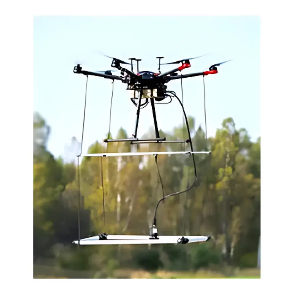
| Platform Integration | UAV-Mountable with Terrain-Tracking Capability |
| Compliance | Designed for UXO Clearance, Utility Locating, and Archaeological Survey Applications |
| Data Output | Georeferenced TEM Measurements |
Overview
The EM61Lite is a high-sensitivity, time-domain electromagnetic (TDEM) metal detector engineered for rapid, non-invasive subsurface metallic object detection. Unlike continuous-wave or frequency-domain systems, the EM61Lite operates on the principle of transient electromagnetic induction: it transmits a brief, high-current magnetic pulse into the ground and precisely measures the decay response of induced eddy currents in conductive targets. This TDEM methodology delivers superior depth penetration, enhanced discrimination between ferrous and non-ferrous metals, and robust performance in electrically noisy or mineralized soils—critical attributes for unexploded ordnance (UXO) clearance, utility mapping, and cultural resource management. Its compact, lightweight design and low-power consumption make it uniquely suited for integration with unmanned aerial vehicles (UAVs), enabling large-area surveys with centimeter-level GPS positioning and real-time terrain-following flight control.
Key Features
- UAV-integrated architecture: Optimized mechanical and electrical interface for seamless mounting on multirotor and fixed-wing platforms.
- True Terrain Tracking (TTF) compatibility: Synchronized altimetry and inertial measurement unit (IMU) data enable stable sensor-to-ground distance maintenance (<±0.5 m) over rugged topography.
- Full-automatic operational mode: Pre-programmed survey grids, autonomous takeoff/landing, and real-time onboard data validation eliminate manual intervention during acquisition.
- Georeferenced time-domain data logging: Each TEM decay curve is timestamped and tagged with WGS84 coordinates, altitude, pitch/roll/yaw, and system health metrics.
- Ruggedized environmental rating: IP65 enclosure with thermal management for sustained operation across –20 °C to +50 °C ambient conditions.
- Low-induction moment design: Minimizes coupling with above-ground infrastructure (e.g., power lines, fences), reducing false positives in urban or industrial settings.
Sample Compatibility & Compliance
The EM61Lite detects both ferrous (e.g., iron, steel) and non-ferrous (e.g., aluminum, copper, brass) metallic objects at depths ranging from 0.3 m to ≥3 m depending on target size, conductivity, orientation, and host soil resistivity. It is routinely deployed in accordance with NATO AEP-57 (UXO Detection Standards), ASTM D6429 (Standard Guide for Electromagnetic Methods for Locating Underground Utilities), and ISO 21397-2 (Geotechnical Investigation — Geophysical Methods — Part 2: Electromagnetic Methods). For regulatory compliance in government-contracted demining or infrastructure assessment, raw TEM data and metadata meet requirements for GLP-aligned documentation, including audit trails, instrument calibration logs (traceable to NIST standards), and version-controlled firmware records.
Software & Data Management
Data acquisition is managed via the proprietary EM61Lite Flight Control & Acquisition Suite (v3.2+), which supports mission planning, real-time telemetry monitoring, and automatic quality assurance flagging (e.g., lift-off anomalies, GPS dropouts, coil saturation events). Processed data export formats include SEG-Y (for interoperability with geophysical processing platforms such as Oasis montaj and Geosoft), CSV (with full parameter headers), and GeoJSON (for GIS integration). The software implements secure local storage with optional AES-256 encryption and supports 21 CFR Part 11–compliant electronic signatures when used in regulated environments requiring documented accountability for data integrity and operator actions.
Applications
- UXO Detection and Risk Mitigation: High-resolution localization of buried ordnance without physical entry into hazardous zones; supports risk-prioritized excavation planning and post-clearance verification.
- Underground Utility Mapping: Accurate identification and horizontal/vertical positioning of metallic pipes, conduits, and cables—essential for pre-excavation “call-before-you-dig” protocols and BIM-integrated infrastructure modeling.
- Archaeological Prospection: Non-destructive, wide-area scanning of sensitive sites; preserves stratigraphic integrity while identifying metallic artifacts, structural remnants, or buried features indicative of human occupation.
- Landfill and Brownfield Characterization: Detection of metallic debris, drums, or reinforcement within capped or disturbed soils—supporting environmental site assessments under ASTM E1527 and EPA guidance.
- Forensic and Law Enforcement Surveys: Rapid deployment for clandestine burial detection or evidence recovery in complex terrain where ground-based access is restricted.
FAQ
What is the typical detection depth for small metallic objects (e.g., 50-mm diameter steel sphere)?
Depth sensitivity depends on ground conductivity and noise environment; under average conditions (soil resistivity ~100 Ω·m), detection range is approximately 1.2–1.8 m.
Does the EM61Lite require ground contact or coupling?
No—it is a fully air-coupled system; no physical contact with the surface is needed, enabling safe operation over contaminated, unstable, or vegetated terrain.
Can raw TEM data be inverted to estimate target depth and conductivity?
Yes—time-domain decay curves are compatible with standard 1D layered-earth inversion algorithms (e.g., laterally constrained inversion) implemented in commercial and open-source geophysical software packages.
Is firmware and software update support provided post-purchase?
Yes—registered users receive biannual firmware updates and annual software releases, including enhancements to noise suppression, terrain-following stability, and metadata schema alignment with ISO 19115-3.
What calibration documentation is supplied with the system?
Each unit ships with a factory calibration certificate (valid for 12 months), traceable to primary standards, plus a user-accessible field calibration routine verified against certified reference targets.


