Geosigma AC-73-DH Borehole Force-Balance Accelerometer
| Origin | Switzerland |
|---|---|
| Manufacturer Type | Authorized Distributor |
| Origin Category | Imported |
| Model | AC-73-DH |
| Instrument Type | Portable |
| Dynamic Range | 165 dB |
| Full-Scale Range | ±0.5, ±1, ±2, ±3, or ±4 g |
| Bandwidth | DC to 200 Hz |
| Power Supply | 9.5–18 V DC (galvanically isolated) |
| Housing Compatibility | ≥100 mm borehole diameter |
| Sensor Architecture | Electro-mechanical force-balance with capacitive position sensing and magnetic restoring force |
Overview
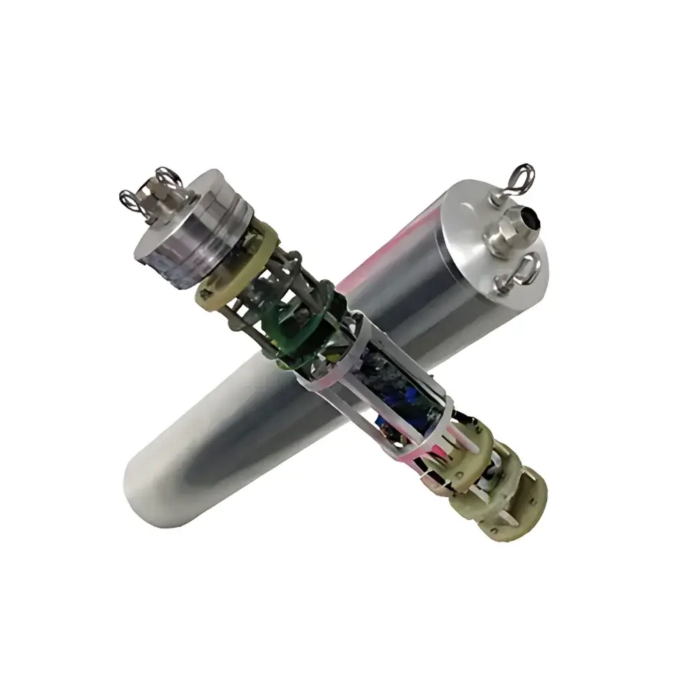
The Geosigma AC-73-DH Borehole Force-Balance Accelerometer is a high-fidelity, three-component seismic sensor engineered for permanent or semi-permanent deployment in vertical or inclined boreholes. It operates on the closed-loop force-balance principle—a metrologically robust method where inertial mass displacement due to ground acceleration is continuously nulled by an electromagnetic feedback current. This architecture ensures linear response, minimal phase distortion, and exceptional long-term stability across its full DC-to-200 Hz bandwidth. Unlike open-loop accelerometers, the AC-73-DH maintains scale factor integrity under thermal drift, mechanical stress, and extended operational periods—critical for structural health monitoring, regional seismic network densification, and regulatory-grade vibration compliance assessment. Its true DC response enables precise static tilt measurement, post-installation calibration verification, and in-situ zero-offset validation without sensor retrieval.
Key Features
- True force-balance design with symmetrical capacitive position sensing and dual-axis magnetic restoration—ensuring scale factor stability ≤±0.05% over –20°C to +60°C
- Galvanically isolated power input (9.5–18 V DC) eliminates ground-loop-induced noise and supports flexible integration with solar-charged battery systems or remote telemetry nodes
- Integrated iSensor™ interface hosting embedded digital sensors: 3-axis MEMS compass (heading accuracy ±1.5°), dual-axis inclinometer (resolution 0.001°), and calibrated temperature/humidity sensors (traceable to NIST standards)
- Electronically adjustable DC offset—eliminates need for mechanical leveling or manual shimming during installation; accommodates misalignment up to ±5°
- Hermetically sealed, stainless-steel borehole housing rated for ≥100 mm diameter installations; compliant with IEC 60529 IP68 and ISO 14644-1 Class 8 cleanroom handling protocols
- Dedicated test loop circuitry—activated only upon command via control line—enables full end-to-end functional verification without introducing external noise coupling
Sample Compatibility & Compliance
The AC-73-DH is designed for direct coupling into geotechnical boreholes using standard grouting or clamping methods. Its cylindrical form factor (Ø92 mm × 320 mm L) and low center-of-gravity configuration ensure mechanical stability in unconsolidated sediments, weathered bedrock, and cased boreholes. The sensor meets ASTM E2128-22 (Standard Guide for Seismic Monitoring of Civil Structures), ISO 2631-1:2010 (Mechanical vibration evaluation of human exposure), and EN 1998-1:2004+A1:2013 (Eurocode 8: Design of structures for earthquake resistance). Data acquisition workflows support GLP-compliant metadata logging—including sensor ID, installation timestamp, orientation quaternion, ambient T/RH, and self-test pass/fail status—facilitating audit-ready reporting per FDA 21 CFR Part 11 requirements when deployed in regulated infrastructure monitoring.
Software & Data Management
Raw output is delivered as differential analog voltage (±10 V full-scale) proportional to acceleration, with optional digital output via RS-485 Modbus RTU or Ethernet TCP/IP (with optional firmware upgrade). Geosigma’s GeoSync™ Acquisition Suite provides real-time spectral analysis (FFT up to 4096 points), event-triggered recording (STA/LTA algorithm), and automatic gain staging based on pre-event noise floor estimation. All calibration coefficients—including sensitivity, phase delay tables, temperature compensation polynomials, and compass hard/soft iron correction matrices—are stored in non-volatile memory and digitally signed to prevent tampering. Export formats include MiniSEED (SEED v2.4), SAC, and CSV with ISO 8601 timestamps and UTC synchronization via PPS or NTP.
Applications
- Regional broadband seismic networks requiring DC-coupled velocity and acceleration integration
- Structural response monitoring of dams, bridges, nuclear facilities, and historical monuments
- Microtremor array surveys (HVSR, SPAC) and site amplification characterization
- Vibration impact assessment near construction zones, railways, and industrial plants per BS 5228-2 and DIN 4150-3
- Post-earthquake rapid damage assessment via permanent array residual displacement analysis
- Geotechnical instrumentation for landslide early warning systems with tilt-acceleration fusion
FAQ
What is the recommended borehole grouting material for optimal coupling?
Geosigma specifies low-viscosity, non-shrinking epoxy grout (e.g., MasterEmaco T 28) with compressive strength ≥40 MPa and thermal expansion coefficient matched to host rock within ±3 ppm/°C.
Can the AC-73-DH be used in sub-zero environments without heater modules?
Yes—the electronics are rated for continuous operation from –20°C to +60°C; internal temperature compensation algorithms remain active across the full range.
Is factory recalibration required annually?
No—due to intrinsic scale factor stability, recalibration is recommended every 36 months or after mechanical shock exceeding 10 g peak; field verification via built-in test loop satisfies ISO/IEC 17025 traceability requirements.
Does the iSensor™ interface support third-party data loggers?
Yes—Modbus RTU register map and Ethernet API documentation are provided under NDA; compatibility confirmed with Campbell Scientific CR6, SymphoniePRO, and Delta-T DL6 data loggers.
How is orientation uncertainty quantified during installation?
The integrated compass and inclinometer provide real-time azimuth and dip estimates; combined uncertainty (1σ) is ±1.8° for heading and ±0.002° for tilt—verified via co-located GNSS-aided surveying.
Related Products