Haglof Postex Multifunctional Tree Measurement System
| Brand | Haglof Inc. |
|---|---|
| Origin | Sweden |
| Model | Postex |
| Dimensions | 93 × 63 × 72 mm |
| Weight (instrument) | 243 g |
| Weight (tripod assembly) | 4.85 kg |
| Ultrasonic Range | ≥30 m (with 360° adapter: ≥20 m) |
| Laser Range | 0.46–700 m |
| Laser Accuracy | ±4 cm |
| Angular Accuracy | ±0.1° |
| Angular Resolution | 0.1° |
| Distance Resolution (ultrasonic) | 0.01 m |
| Distance Resolution (laser, DME mode) | 0.01 m |
| Operating Temperature | −20 °C to +45 °C |
| IP Rating | IP67 / NEMA 6 |
| Laser Class | IEC 60825-1:2001 Class 1M, FDA 21 CFR Part 1040.10 Class 1 |
| Battery | Internal 3.7 V rechargeable Li-ion (~9,000 measurements per charge |
| Interface | USB Mini-B, Bluetooth SPP (PIN: 1234), IR |
| Data Output Format | NMEA or ASCII |
| Tripod Arm Extension | Up to 125 cm from center |
| Reflector Beacon (A/B/C) | Ø70 mm, 85 g each, 1.5 V AA alkaline, max. 9 mW |
Overview
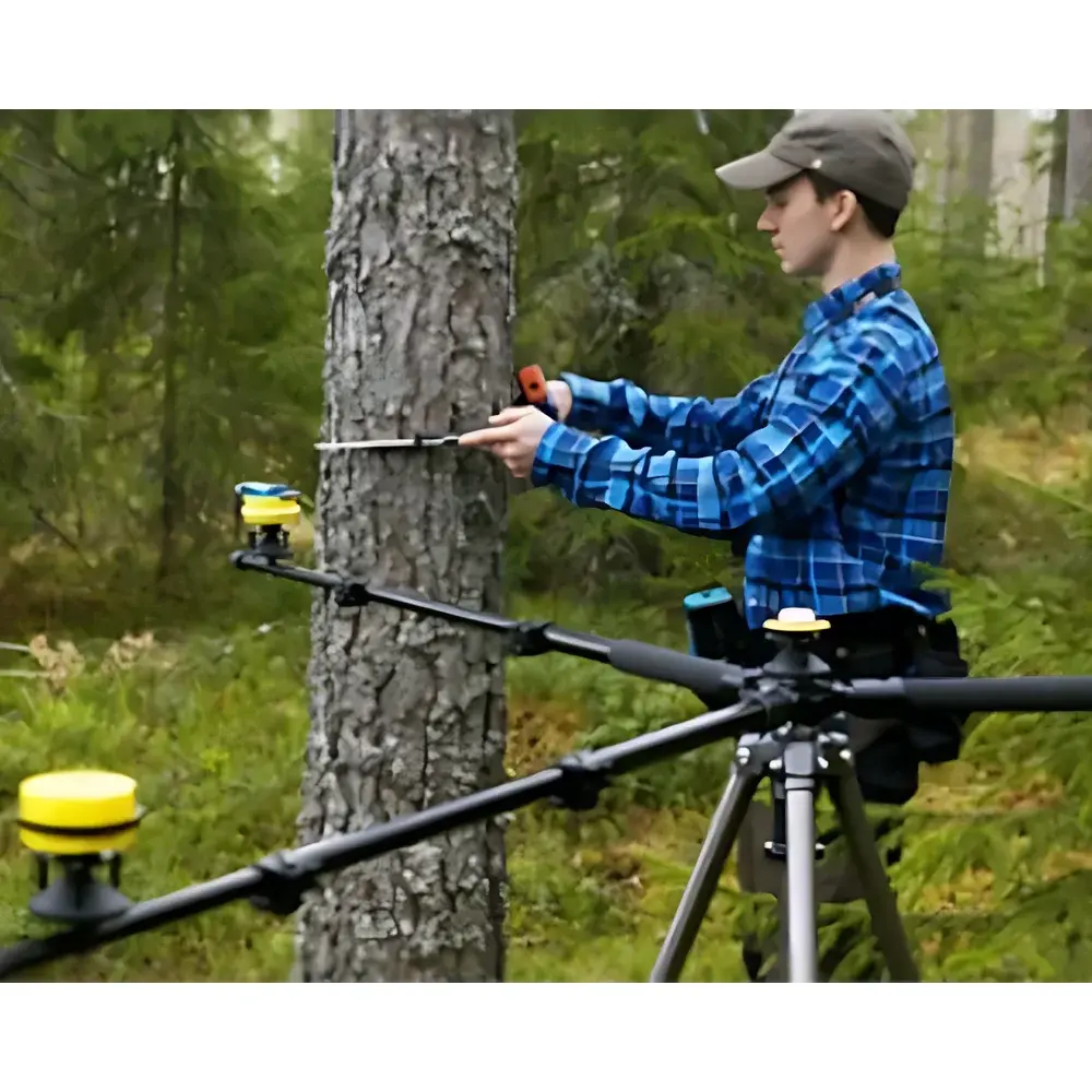
The Haglof Postex Multifunctional Tree Measurement System is a field-deployable geospatial instrumentation platform engineered for high-efficiency, non-destructive forest inventory and ecological plot mapping. It operates on a hybrid principle combining time-of-flight ultrasonic triangulation and Class 1M laser distance measurement to determine precise 3D coordinates of individual trees within a defined sampling area. Unlike traditional tape-and-clinometer methods or GPS-based solutions with sub-meter positional uncertainty, the Postex system establishes a local coordinate reference frame using three synchronized acoustic beacons (A, B, C), enabling centimeter-level spatial reproducibility without reliance on satellite signal integrity. This architecture makes it particularly suited for ground-truthing airborne LiDAR datasets in temperate and boreal forests—where canopy closure often degrades GNSS accuracy—and for longitudinal studies requiring repeatable, operator-independent positioning across seasons and survey cycles.
Key Features
- Triangulation-Based Spatial Mapping: Uses real-time ultrasonic distance measurements from three fixed, battery-powered reflectors to compute X/Y/Z coordinates of each tree stem base with ≤1% relative error over distances up to 30 m.
- Integrated Laser Height Profiling: VL5 and L5 laser modules provide direct vertical height estimation from ground to crown base or treetop, calibrated against inclinometric angle data and slope-compensated distance readings.
- Modular System Configurations: Three validated deployment tiers—System 1 (Postex Laser), System 2 (DP Postex L5 with DP II caliper integration), and System 3 (DP II terminal-only localization)—allow scalability from basic plot georeferencing to full biometric acquisition including DBH (diameter at breast height).
- Ruggedized Field Architecture: IP67/NEMA 6-rated housing ensures operational continuity in rain, dust, and temperature extremes (−20 °C to +45 °C); MIL-STD-810E-compliant vibration resistance supports transport and use on uneven terrain.
- Low-Power Embedded Electronics: Internal 3.7 V Li-ion battery supports ~9,000 discrete measurements per charge; beacon units operate on standard AA alkaline cells with ultra-low 9 mW quiescent draw.
- Multi-Protocol Connectivity: Onboard Bluetooth SPP (with secure PIN authentication), infrared, and USB Mini-B interfaces enable seamless data streaming to rugged tablets or laptops running Postax software.
Sample Compatibility & Compliance
The Postex system is optimized for woody perennial species in natural and managed forests—including conifers, broadleaf deciduous, and mixed-species stands—where stem diameter exceeds 5 cm and vertical structure permits unobstructed line-of-sight between instrument and reflector array. Its ultrasonic transducers perform robustly in ambient noise environments typical of forest understories (<85 dB(A)), while the Class 1M laser meets IEC 60825-1:2001 and FDA 21 CFR Part 1040.10 safety requirements for unrestricted outdoor use. All hardware and firmware comply with EU RoHS Directive 2011/65/EU and CE marking standards. Data acquisition workflows support GLP-aligned metadata tagging (operator ID, timestamp, GPS-assisted site ID, environmental conditions) and are compatible with ISO 7348 (forest inventory terminology) and ASTM D143 (wood sampling procedures) documentation frameworks.
Software & Data Management
Postax—the native Windows-based application suite—provides end-to-end data handling: instrument configuration, real-time field visualization, post-processing coordinate transformation (e.g., local UTM to WGS84), and export to GIS-ready formats (CSV, Shapefile, GeoJSON). The software enforces structured data entry through customizable templates aligned with national forest inventory protocols (e.g., USDA FIA, EFISCEN). Audit trails log all parameter changes, calibration events, and user actions in accordance with ALCOA+ principles (Attributable, Legible, Contemporaneous, Original, Accurate, Complete, Consistent, Enduring, Available). Exported ASCII/NMEA logs retain full precision (0.01 m distance, 0.1° angular resolution) and embed instrument serial numbers and firmware revision identifiers for traceability in peer-reviewed publications or regulatory submissions.
Applications
- Ground-truth validation of airborne LiDAR-derived canopy height models (CHMs) and digital terrain models (DTMs)
- Long-term monitoring of individual tree growth dynamics in permanent sample plots (PSPs)
- Species-specific spatial distribution analysis in biodiversity surveys
- Pre-harvest inventory planning with DBH-height allometry integration
- Carbon stock estimation via allometric equations requiring georeferenced stem metrics
- Ecological restoration site mapping and survival tracking of planted individuals
- University field courses in dendrometry, forest mensuration, and spatial ecology
FAQ
What is the minimum measurable tree height using the L5 laser module?
The L5 laser achieves reliable ranging from 46 cm upward; practical lower limit for height measurement is ~1.3 m when accounting for tripod setup height and operator ergonomics.
Can Postex data be imported directly into ArcGIS or QGIS?
Yes—Postax exports georeferenced point layers with attribute tables (X, Y, Z, DBH, height, species code) in ESRI Shapefile and GeoJSON formats, fully compatible with both ArcGIS Pro and QGIS 3.x.
Is firmware update supported in the field?
Firmware updates are performed via USB connection using Postax’s built-in updater; no internet access required during deployment.
How does the system handle sloped terrain during ultrasonic triangulation?
The integrated inclinometer continuously measures pitch and roll; all distance calculations and coordinate transformations apply real-time tilt compensation using onboard quaternion-based orientation algorithms.
Are calibration certificates provided with each unit?
Each Postex instrument ships with a factory calibration report traceable to Swedish National Metrology Institute (RISE) standards; optional annual recalibration services are available through Haglof’s authorized service centers in Europe and North America.