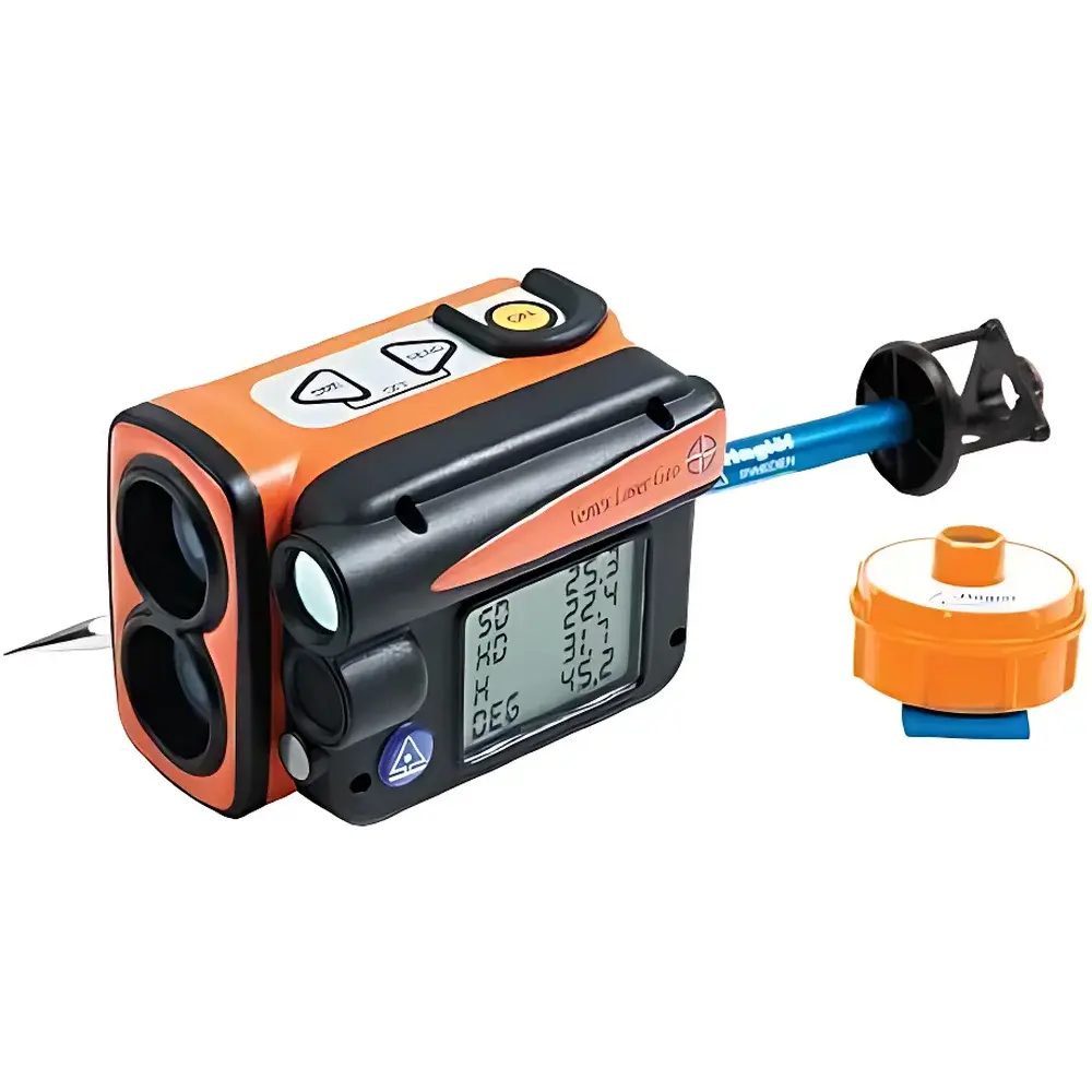
HAGLOF Vertex Laser Geo Laser-Ultrasonic Height and Distance Meter
| Brand | HAGLOF INC |
|---|---|
| Origin | Sweden |
| Model | Vertex Laser Geo |
| Product Type | Handheld |
| Measurement Principle | Laser & Ultrasonic Ranging |
| Measurement Range | 0–5000 m² (area), 0.46–700 m (laser), 0–30 m (ultrasonic, 0–20 m with 360° transceiver) |
| Accuracy | ±4 cm (laser distance), ≤1% (ultrasonic distance), ±0.1° (inclination), <2.5 m (GPS horizontal), <1.5° RMSE (compass) |
| Resolution | 0.1 m (height/distance), 0.1° (angle), 0.01 m (ultrasonic), 0.1° (compass) |
| Display | 100×60 pixel LCD with integrated HUD |
| Environmental Rating | IP67 / NEMA 6 |
| Operating Temperature | −20 °C to +45 °C |
| Weight | 243 g (instrument, incl. battery) |
| Battery | Built-in 3.7 V Li-ion (9000 measurements per charge, ~3.5 h recharge) |
| Connectivity | Bluetooth® BLE 4.0 Class 2, IR, USB 2.0, SSD disk emulation |
| Data Storage | 2000 non-volatile records (CSV format) |
| GPS | 33-channel high-sensitivity receiver |
| Compass | 0–360°, 0.1° resolution |
| Aiming | Red-dot crosshair (1× magnification), laser spot targeting |
Overview
The HAGLOF Vertex Laser Geo is a field-deployable, handheld laser-ultrasonic height and distance meter engineered for precision forestry and ecological surveying in complex vegetated environments. Unlike conventional optical or single-technology rangefinders, the Vertex Laser Geo integrates dual-mode ranging—time-of-flight laser measurement for line-of-sight targets and ultrasonic pulse-echo detection for obscured or diffuse targets—enabling reliable acquisition of vertical height, horizontal distance, inclination angle, and canopy-width metrics under variable canopy closure. Its core architecture embeds a 33-channel GPS receiver, solid-state electronic compass (<1.5° RMSE), and inertial tilt sensor to deliver georeferenced 3D point coordinates (X, Y, Z) with sub-meter horizontal accuracy and 0.1 m vertical resolution. The instrument operates on the principle of hybrid signal propagation: laser pulses (650 nm visible red diode) provide high-resolution distance data where direct target visibility exists; ultrasonic waves (40 kHz transceiver array in T3 module) penetrate foliage and return from volumetric scatterers such as leaf clusters or branch intersections—making it uniquely suited for forest structure analysis, biomass estimation, and understory profiling. All measurements are timestamped, geotagged, and stored in non-volatile memory compliant with long-term archival standards.
Key Features
- Dual-mode ranging engine: Selectable laser (0.46–700 m, ±4 cm) or ultrasonic (0–30 m standard, 0–20 m with 360° T3 transceiver, ≤1% accuracy) based on real-time site conditions
- Integrated GNSS/INS navigation: 33-channel GPS receiver with <2.5 m CEP (95%) horizontal accuracy; electronic compass calibrated to <1.5° RMSE across full 0–360° azimuth range
- Ruggedized industrial design: IP67 and NEMA 6 ingress protection; operational between −20 °C and +45 °C; shock-absorbing housing tested to MIL-STD-810G drop specifications
- Intelligent environmental adaptation: Automatic “Rain Mode” activation upon moisture detection to suppress acoustic interference and recalibrate ultrasonic gain profiles
- Multi-modal aiming system: Red-dot crosshair (1× fixed magnification) for close-range angular alignment; collimated laser spot for distant target acquisition—both overlaid on integrated head-up display (HUD)
- Onboard data processing: Real-time calculation of height, horizontal distance, slope percentage, crown width, and area (0–5000 m²); support for hectare (0.5–10,000 ha) and square foot (0–20,000 ft²) units
- Expandable ecosystem: Compatible with optional T3 ultrasonic transceiver (AA-powered, 85 g) and telescopic pole (33–140 cm, 270 g) for ground-based vertical profiling and multi-level sampling
Sample Compatibility & Compliance
The Vertex Laser Geo is validated for use with heterogeneous biological targets including deciduous and coniferous tree canopies, shrub layers, standing deadwood, and ground-level vegetation structures. Its ultrasonic mode demonstrates consistent response across target densities exceeding 85% LAI (Leaf Area Index), while laser mode maintains repeatability on bark surfaces with reflectance >15%. The device complies with IEC 61000-6-2 (immunity) and IEC 61000-6-4 (emissions) for industrial environments. Firmware supports GLP-compliant audit trails—including operator ID, GPS fix status, sensor calibration timestamps, and measurement mode selection logs—required for ISO/IEC 17025-accredited forestry laboratories. Data export formats (NMEA 0183, ASCII CSV) align with FAO-FRA reporting templates and USDA Forest Service FIA protocols. No FDA or medical device classification applies; CE marking covers EMC and RoHS directives.
Software & Data Management
Data transfer occurs via three concurrent interfaces: Bluetooth® BLE 4.0 (SPP profile, PIN 1234), infrared (IrDA 1.1), and USB 2.0 mass-storage mode (SSD disk emulation). Field-collected datasets (up to 2000 records) are stored in comma-separated value (CSV) format with mandatory fields: UTC timestamp, WGS84 latitude/longitude (DD), ellipsoidal height (m), measured distance (m), inclination (°), azimuth (°), ranging mode (L/U), GPS HDOP, and 5-digit site ID. HAGLOF’s proprietary GeoSync desktop application (Windows/macOS) enables batch georeferencing, error propagation analysis, canopy layer segmentation, and export to ESRI Shapefile, KML, and FGDC metadata-compliant XML. All firmware updates are digitally signed and verified prior to installation, satisfying integrity requirements under FDA 21 CFR Part 11 for electronic records in regulated research settings.
Applications
- Forest inventory: Individual tree height, DBH proxy estimation, crown base height, and stand density index (SDI) mapping
- Ecological monitoring: Canopy gap fraction analysis, vertical stratification profiling, and successional stage classification
- Carbon stock assessment: Integration with allometric equations for aboveground biomass (AGB) modeling per IPCC Tier 2 guidelines
- Wildlife habitat evaluation: Understory openness quantification, nesting platform height verification, and corridor permeability indexing
- Post-disturbance assessment: Pre- and post-harvest height differentials, windthrow detection, and salvage logging planning
- Educational fieldwork: Student-led dendrometry exercises with real-time coordinate visualization and collaborative GIS layering
FAQ
What distinguishes laser mode from ultrasonic mode in practical field use?
Laser mode requires unobstructed line-of-sight to a reflective surface (e.g., trunk or exposed branch) and delivers ±4 cm accuracy up to 700 m. Ultrasonic mode emits omnidirectional 40 kHz pulses that reflect from volumetric features—even through partial foliage—and is preferred when target visibility is limited or when measuring average canopy depth.
Is GPS position data logged with every measurement?
Yes. Each record includes raw NMEA GGA and VTG sentences, enabling post-processing with differential correction services (e.g., EGNOS, WAAS) to achieve sub-meter horizontal precision where available.
How is calibration maintained in humid or rainy conditions?
The device performs automatic acoustic gain adjustment and temperature-compensated time-of-flight correction during Rain Mode. Laser calibration remains unaffected, as the optical path is sealed and internally stabilized.
Can the Vertex Laser Geo interface with third-party GIS platforms?
All exported CSV files contain standardized coordinate and attribute headers compatible with QGIS, ArcGIS Pro, and Global Mapper. GeoSync also supports direct OGC WFS/WMS publishing for enterprise spatial databases.
What battery life can be expected during continuous operation?
A fully charged internal 3.7 V Li-ion battery supports approximately 9000 discrete measurements (mixed-mode usage), equivalent to 12–14 hours of intermittent fieldwork. Recharge time is 3.5 hours via USB-C adapter (not included).