AM-IoT100 All-Weather Autonomous UAV Remote Sensing and Telemetry System
| Brand | — |
|---|---|
| Origin | Beijing, China |
| Manufacturer Type | Authorized Distributor |
| Regional Classification | Domestic (China) |
| Model | AM-IoT100 |
| Pricing | Available Upon Request |
Overview
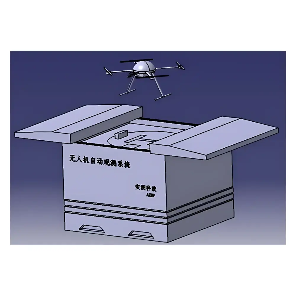
The AM-IoT100 All-Weather Autonomous UAV Remote Sensing and Telemetry System is an integrated environmental monitoring platform engineered for continuous, unattended operation in ecological and industrial field deployments. Built upon a robust IoT architecture, the system implements a closed-loop telemetry workflow combining autonomous flight operations, edge-based sensor data acquisition, and cloud-native data orchestration. Its core measurement paradigm relies on multi-spectral, thermal, and visual remote sensing—leveraging calibrated payload interfaces to capture georeferenced spectral reflectance, surface temperature differentials, and high-resolution visible-light imagery. Designed specifically for long-term ecological surveillance, pollution source tracing, land-use change detection, and infrastructure integrity assessment, the AM-IoT100 conforms to operational requirements defined in ISO 18404:2015 (Geospatial data quality for environmental monitoring) and supports metadata compliance with OGC SensorML and ISO 19115-2 standards.
Key Features
- Fully autonomous mission cycle: automatic takeoff, pre-programmed waypoint navigation, real-time adaptive path correction, precision landing, battery swap or in-situ charging, and post-flight data upload—all orchestrated without human intervention.
- Modular payload interface supporting standardized gimbal mounts (M3 × 0.5 thread pitch) for rapid integration of multispectral sensors (e.g., 5-band VNIR spectrometers, 320 × 240 microbolometer thermal imagers), low-light CMOS cameras, and dual-spectrum (visible + thermal) imaging systems.
- Intelligent hangar with IP54 ingress protection, active temperature/humidity regulation (operational range: −30 °C to +60 °C), integrated UPS backup (30 min runtime at 25 °C), and vision-guided docking alignment achieving ≤10 cm lateral and vertical landing accuracy.
- Cloud-based IoT platform compliant with TLS 1.2+ encrypted communications, offering role-based access control (RBAC), audit-trail logging per ISO/IEC 27001, and support for FDA 21 CFR Part 11–compliant electronic signatures in regulated environmental reporting workflows.
- Onboard GNSS-RTK positioning delivering horizontal accuracy ≤1 cm and vertical accuracy ≤2 cm (with base station correction), synchronized with onboard IMU and barometric altimeter for flight stability under wind loads up to 8 m/s (Beaufort scale 5).
Sample Compatibility & Compliance
The AM-IoT100 accommodates heterogeneous sensor payloads conforming to CE EN 301 489-1 (EMC), FCC Part 15 Subpart B (RF emissions), and RoHS Directive 2011/65/EU. Its environmental telemetry outputs—including five-element meteorological data (air temperature, relative humidity, wind speed/direction, atmospheric pressure, and precipitation estimation)—are structured in JSON-LD format aligned with WMO OSCAR/Surface metadata conventions. The system supports deployment in GLP-compliant field studies and integrates with third-party LIMS via RESTful API endpoints adhering to OpenAPI 3.0 specifications. All firmware updates undergo cryptographic signature verification prior to installation.
Software & Data Management
The IoT cloud platform provides web-based dashboards with configurable KPI widgets for NDVI time-series analysis, thermal anomaly heatmaps, and orthomosaic generation pipelines using structure-from-motion (SfM) algorithms. Raw telemetry streams (including GPS logs, IMU quaternions, sensor timestamps, and payload status flags) are retained for ≥180 days with immutable write-once storage architecture. Export formats include GeoTIFF (georeferenced rasters), CSV (tabular sensor readings), and NetCDF-4 (multi-dimensional environmental time series). Audit logs record all user-initiated actions—including task scheduling, parameter modification, and data download—with UTC timestamps and SHA-256 hash integrity verification.
Applications
- Long-term ecological monitoring: phenology tracking across forest canopies, wetland vegetation classification, and invasive species mapping using normalized difference vegetation index (NDVI) and red-edge band ratios.
- Industrial emission surveillance: thermal plume detection over stack outlets, particulate dispersion modeling via sequential RGB+thermal co-registration, and fugitive VOC hotspot localization using multispectral anomaly thresholds.
- Critical infrastructure inspection: automated corridor scanning of power transmission lines, solar farm panel defect identification via thermographic deviation scoring, and dam surface crack detection through sub-pixel resolution orthomosaics.
- Disaster response coordination: rapid post-event terrain change assessment (e.g., landslide volume estimation), flood extent delineation using NIR-water absorption contrast, and emergency resource allocation routing based on real-time airspace occupancy maps.
FAQ
Does the AM-IoT100 support beyond-visual-line-of-sight (BVLOS) operations?
Yes—when deployed with certified ground control stations and integrated into national UTM frameworks (e.g., China’s UOMS or EU’s U-space), BVLOS missions comply with CAAC AC-92-A and EASA UAS.SPEC.050 regulatory requirements.
Can raw sensor data be accessed programmatically for custom analytics?
Yes—the system exposes a documented REST API with OAuth 2.0 authentication, enabling direct retrieval of unprocessed payload frames, GNSS logs, and environmental telemetry in near real-time (latency < 2 s end-to-end).
What redundancy mechanisms ensure system uptime during extended field deployments?
Dual-path LTE/5G failover connectivity, redundant power input (220 V AC + optional solar hybrid), and autonomous hangar self-diagnostic routines—including battery health forecasting, motor vibration trending, and thermal runaway prevention—ensure >99.2% scheduled availability over 12-month cycles.
Is the cloud platform compatible with existing enterprise GIS platforms?
Yes—it natively publishes WMS/WFS services conforming to OGC 1.3.0 specifications and supports direct synchronization with Esri ArcGIS Enterprise, QGIS Server, and Bentley Map Web Services via standard OGC endpoints.
Related Products


