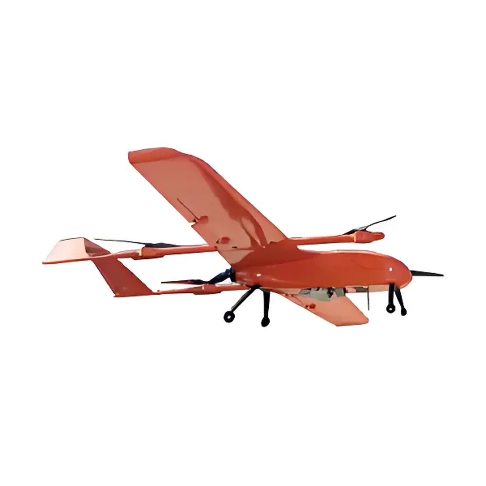
LiDAR Hawk VTOL UAV-Based Long-Range LiDAR System
| Brand | — |
|---|---|
| Origin | Beijing, China |
| Manufacturer Type | Authorized Distributor |
| Regional Classification | Domestic |
| Model | Liar Hawk |
| Pricing | Upon Request |
| Flight Platform | VTOL Fixed-Wing UAV |
| Propulsion | All-Electric |
| Endurance | 1.5 h |
| Cruise Speed | 70–80 km/h |
| LiDAR Sensor | RIEGL VUX-1LR |
| Vertical Absolute Accuracy | 5 cm @ 200 m AGL |
| Measurement Range | 5–1350 m (≥60% reflectivity) |
| Ranging Accuracy | ±1.5 cm |
| FOV | 330° |
| Scan Frequency | 10–200 Hz |
| Angular Resolution | 0.001° |
| Max Effective Point Rate | 750,000 pts/sec (@820 kHz PRR & 330° FOV) |
| GNSS Constellations | GPS, GLONASS, Galileo, BeiDou |
| Post-Processed Attitude Accuracy | 0.006° (1σ) |
| Post-Processed Heading Accuracy | 0.019° (1σ) |
| System Weight | 5.3 kg |
| Software Suite | Onboard LiDAR Control & GNSS/INS Data Processing Software |
| Optional | Point Cloud Analysis Software |
Overview
The LiDAR Hawk is a high-performance, VTOL (Vertical Take-Off and Landing) fixed-wing unmanned aerial vehicle (UAV) platform integrated with a long-range, survey-grade airborne LiDAR system. Engineered for ecological and environmental remote sensing applications, it combines the RIEGL VUX-1LR time-of-flight laser scanner with a tightly coupled GNSS/INS navigation system and a full-frame RGB camera to simultaneously acquire georeferenced point cloud data and high-resolution imagery. Unlike conventional helicopter or multirotor platforms, the LiDAR Hawk leverages fixed-wing aerodynamic efficiency for extended coverage per flight—enabling rapid, large-area topographic mapping, vegetation structure analysis, corridor surveys (e.g., power lines, pipelines), and dynamic terrain change detection. Its measurement principle relies on precise time-of-flight (ToF) computation of pulsed infrared laser returns, corrected in real time via dual-antenna GNSS carrier-phase positioning and inertial measurements, yielding centimeter-level vertical accuracy without requiring ground-based base stations.
Key Features
- VTOL Fixed-Wing Architecture: Combines runway-free vertical takeoff/landing capability with fixed-wing endurance and speed—eliminating logistical constraints of launch/recovery zones while sustaining >70 km/h cruise velocity over 1.5-hour missions.
- True RTK-Free Operation: Integrates real-time access to nationwide CORS (Continuously Operating Reference Station) networks via embedded cellular or satellite telemetry, enabling absolute geolocation accuracy without local base station deployment—even across remote or cross-regional survey areas.
- End-to-End Workflow Integration: Delivers synchronized acquisition, onboard GNSS/INS post-processing, raw point cloud generation, colorization using co-registered imagery, and metadata tagging—all within a single operational software environment compliant with ISO 19115 metadata standards.
- High-Fidelity Sensor Fusion: The RIEGL VUX-1LR sensor operates at up to 820 kHz pulse repetition rate with 330° field-of-view scanning, supporting multi-echo returns and waveform digitization—critical for penetrating vegetation canopies and resolving sub-decimeter surface features in forested or urban environments.
- Robust Environmental Certification: Designed for operation under IP54-rated conditions; thermal management and vibration isolation ensure stable performance across ambient temperatures from –10°C to +45°C and wind speeds up to 12 m/s.
Sample Compatibility & Compliance
The LiDAR Hawk is optimized for heterogeneous environmental sampling—including forest canopy profiling, riverbank erosion monitoring, landslide displacement tracking, coastal zone mapping, and infrastructure corridor inventory. Its 5–1350 m operational range and ≥60% reflectivity threshold ensure reliable return detection across soil, rock, water surfaces, and foliage. The system adheres to international geospatial data quality frameworks including ASPRS LAS 1.4 specification for point cloud deliverables and supports metadata tagging aligned with INSPIRE and ISO 19115–1:2014. All GNSS/INS post-processing workflows are traceable and audit-ready for GLP-compliant environmental reporting. While not FDA- or USP-regulated, its positional accuracy and repeatability meet ASTM E2847–21 requirements for airborne LiDAR topographic mapping and ISO/IEC 17025–2017 criteria for measurement uncertainty quantification in field-deployed instrumentation.
Software & Data Management
Control and data processing are managed through a unified desktop application supporting mission planning, real-time telemetry monitoring, and automated post-mission GNSS/INS trajectory refinement using RINEX-compliant observation files. Raw LiDAR data is output in industry-standard LAS/LAZ format (v1.4), with embedded coordinate reference system (CRS) definitions and calibrated radiometric intensity values. The optional point cloud analysis module provides tools for digital terrain model (DTM) extraction, canopy height modeling (CHM), volumetric calculation (e.g., stockpile or sediment volume), and change detection via iterative surface matching (ISM). All software modules maintain full audit trails—including user actions, parameter configurations, and processing timestamps—to support 21 CFR Part 11-compliant electronic record integrity where required by regulatory environmental assessment protocols.
Applications
- Large-scale ecological habitat mapping and biodiversity corridor assessment
- High-resolution floodplain modeling and hydrological network extraction
- Post-wildfire burn severity classification and regrowth monitoring
- Longitudinal monitoring of glacial retreat, permafrost degradation, and coastal erosion
- Pre-construction terrain modeling for renewable energy site selection (wind/solar farms)
- Regulatory compliance reporting for national ecological redline zones and protected area management
FAQ
Does the LiDAR Hawk require a local GNSS base station for georeferencing?
No. It utilizes real-time correction streams from national CORS infrastructure via integrated LTE or satellite communication, eliminating dependency on local base stations.
What level of point cloud density can be achieved at 200 m AGL?
At typical survey altitudes (150–300 m AGL) and 750,000 pts/sec output, average point spacing ranges from 3–8 cm horizontally, depending on forward speed and overlap configuration.
Is the system compatible with third-party photogrammetry or GIS platforms?
Yes. LAS/LAZ exports are natively supported in Esri ArcGIS Pro, QGIS, Global Mapper, and Bentley ContextCapture; RGB imagery is delivered in GeoTIFF with rational polynomial coefficients (RPCs).
Can the system operate in GNSS-denied environments such as dense forest canopies or urban canyons?
While GNSS availability degrades under full canopy or tall structures, the high-grade IMU enables short-term dead-reckoning (up to 60 s) with bounded drift; optimal results are achieved with ≥50% sky visibility during flight.
What documentation is provided for calibration and traceability?
Each unit ships with factory calibration reports for LiDAR boresight, IMU bias/temperature coefficients, and GNSS antenna phase center offsets—traceable to NIST-equivalent metrology labs in China’s National Institute of Metrology (NIM) framework.