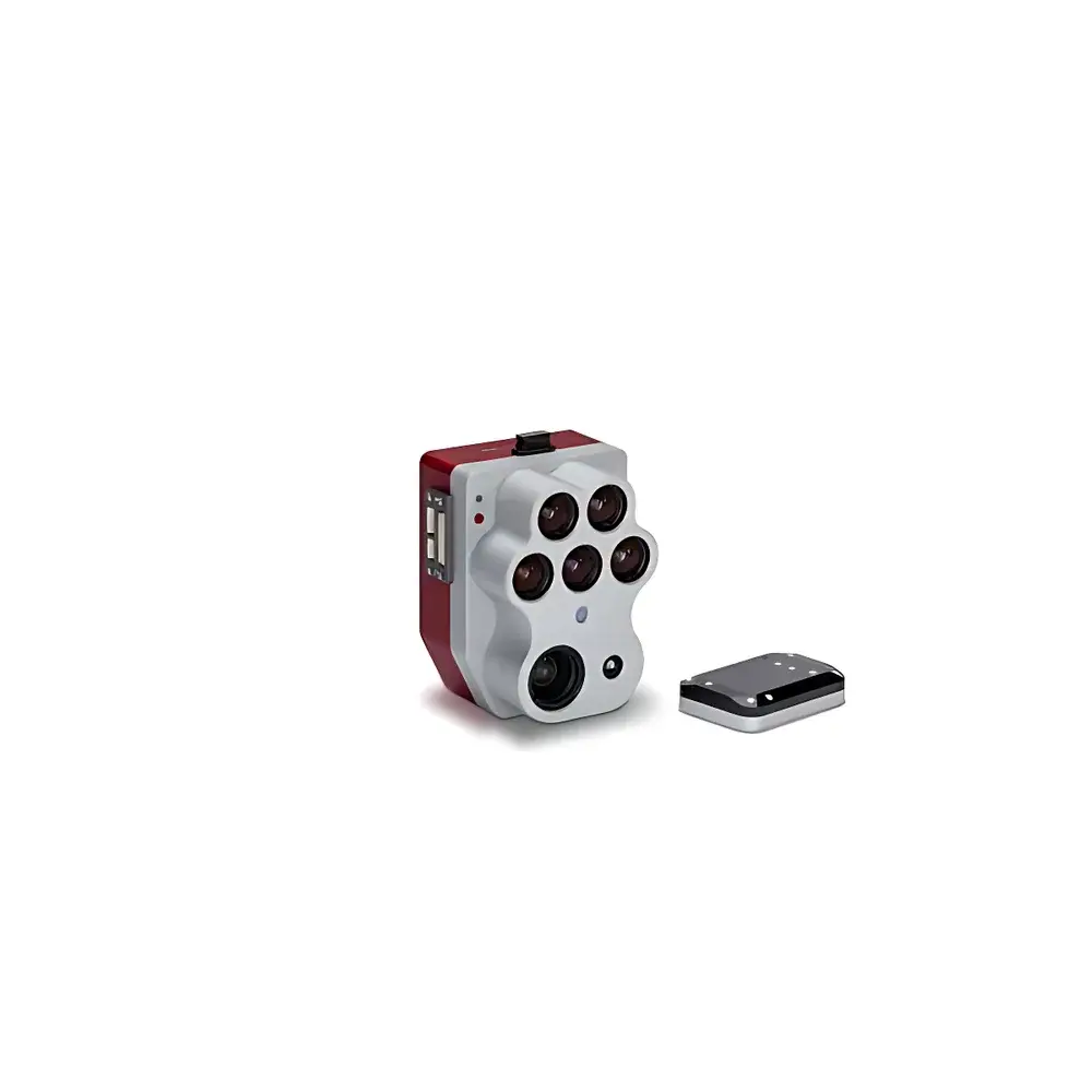
MicaSense Altum-PT Tri-Sensor Multispectral Imaging System
| Brand | MicaSense |
|---|---|
| Model | Altum-PT |
| Weight | 460 g |
| Dimensions | 11.0 × 8.0 × 6.9 cm |
| Spectral Sensor Resolution | 2064 × 1544 (3.2 MP per band) |
| Panchromatic Sensor Resolution | 4112 × 3008 (12 MP) |
| Thermal Sensor | 320 × 256 FLIR Boson® |
| GSD @ 120 m | 5.28 cm (multispectral), 2.49 cm (panchromatic), 33.5 cm (thermal) |
| FOV | 50° H × 38° V (multispectral), 46° H × 35° V (panchromatic), 48° × 39° (thermal) |
| Capture Rate | ≥2 fps (raw DNG) |
| Storage | CFexpress Type B card |
| Spectral Bands | Blue (475 nm, 32 nm BW), Green (560 nm, 27 nm), Red (668 nm, 14 nm), Red Edge (717 nm, 12 nm), NIR (842 nm, 57 nm), Thermal LWIR (7.5–13.5 µm) |
| Pixel Alignment | Hardware-synchronized, co-registered output |
Overview
The MicaSense Altum-PT is a tri-sensor multispectral imaging system engineered for high-fidelity, synchronized acquisition of panchromatic, multispectral, and long-wave infrared (LWIR) data in a single pass. Unlike conventional sequential or post-processed fusion approaches, the Altum-PT integrates three optically independent sensors—each with dedicated optics, calibration, and timing—within a rigid mechanical housing to ensure sub-pixel spatial registration across all modalities. Its core measurement principle relies on simultaneous photon capture under identical illumination and geometric conditions: the 12-megapixel panchromatic sensor provides high-resolution spatial context; the five-band multispectral array (475–842 nm) enables quantitative vegetation index derivation (e.g., NDVI, NDRE, CIrededge); and the uncooled 320 × 256 FLIR Boson® thermal imager delivers radiometrically calibrated surface temperature data in the 7.5–13.5 µm atmospheric window. This hardware-level synchronization eliminates interpolation artifacts and georeferencing drift between bands—a critical requirement for time-sensitive phenotyping, precision irrigation scheduling, and early stress detection in agronomic research and operational remote sensing.
Key Features
- Hardware-synchronized tri-sensor architecture ensuring pixel-perfect alignment of panchromatic, multispectral, and thermal datasets without software-based co-registration.
- Panchromatic pan-sharpening capability: The 12 MP panchromatic channel (2.49 cm GSD at 120 m) enhances spatial fidelity of multispectral bands via proprietary fusion algorithms, delivering effective ground sampling distances up to 2× finer than legacy Altum systems.
- Dual-resolution thermal imaging: With native 320 × 256 resolution and 33.5 cm GSD at 120 m, the integrated Boson® module achieves twice the spatial detail of its predecessor—enabling discrimination of individual plant canopies, irrigation uniformity assessment, and microclimate mapping at field scale.
- CFexpress Type B storage interface supporting sustained write speeds >1.5 GB/s, enabling reliable ≥2 fps raw DNG capture during high-speed UAV operations (e.g., fixed-wing platforms at >12 m/s).
- Factory-calibrated spectral response curves traceable to NIST standards; onboard DLS2 (Downwelling Light Sensor) provides real-time irradiance compensation for reflectance normalization across varying solar angles and atmospheric conditions.
- Ruggedized aluminum alloy enclosure rated IP64 for dust and water resistance; operating temperature range: −10 °C to +50 °C.
Sample Compatibility & Compliance
The Altum-PT is designed for integration with industry-standard UAV platforms (e.g., DJI Matrice 300 RTK, WingtraOne, senseFly eBee X) and supports both GNSS-RTK and PPK workflows for centimeter-level geotagging accuracy. Its spectral band configuration complies with ASTM E2593-21 (Standard Practice for Remote Sensing of Vegetation Health) and aligns with USDA-NRCS crop monitoring protocols. Radiometric calibration adheres to ISO 18526-2:2021 (Earth observation — Calibration and validation of optical sensors — Part 2: On-board calibration). All firmware and embedded metadata conform to Exif 2.3 and XMP schema extensions defined in the DroneDeploy and Pix4D metadata standards. The system supports FDA 21 CFR Part 11-compliant audit trails when used with MicaSense’s enterprise-grade AgVault software suite for GLP/GMP-aligned agricultural trials.
Software & Data Management
Data acquisition is managed through the open-source MicaSense RedEdge SDK and compatible third-party flight controllers (e.g., ArduPilot, PX4). Raw DNG files embed full sensor metadata—including exposure time, gain, lens distortion coefficients, and DLS2 irradiance values—enabling reproducible radiometric processing. Post-acquisition, users leverage the MicaSense Atlas cloud platform or local AgVault desktop application for batch radiometric correction, orthomosaic generation, index computation, and time-series analytics. All processing pipelines generate FAIR-compliant outputs (Findable, Accessible, Interoperable, Reusable), including GeoTIFFs with embedded coordinate reference systems (EPSG:4326 or UTM zones), CSV reports with per-pixel reflectance and temperature statistics, and JSON-formatted metadata logs compliant with the OGC SensorThings API standard.
Applications
- Agronomic phenotyping: Quantification of canopy structure, chlorophyll content, water use efficiency, and thermal stress indices across breeding trials and variety evaluation plots.
- Early-season crop emergence mapping: Detection of seedling stand counts and spatial variability at <10 cm GSD using pan-sharpened multispectral composites.
- Irrigation optimization: Spatially explicit evapotranspiration modeling via combined NDVI and canopy temperature gradients (Crop Water Stress Index, CWSI).
- Forestry inventory: Individual tree crown delineation and health classification in juvenile stands using fused panchromatic-texture and thermal contrast features.
- Soil moisture estimation: Correlation of thermal inertia signatures with volumetric water content in bare-soil scenarios during pre-planting surveys.
- Regulatory compliance reporting: Generation of auditable datasets for USDA EQIP, EU CAP, and national agri-environmental monitoring programs requiring traceable spectral metrics.
FAQ
Does the Altum-PT require external calibration targets during flight?
No. The integrated DLS2 sensor continuously measures downwelling irradiance, and factory-applied radiometric coefficients enable absolute reflectance retrieval without in-field panel captures—though reflectance panels are recommended for mission-critical validation.
Can thermal and multispectral data be exported as separate, georeferenced rasters?
Yes. Atlas and AgVault support independent export of orthorectified GeoTIFFs for each sensor modality, preserving native resolution and coordinate system integrity.
Is the CFexpress card hot-swappable during operation?
No. CFexpress cards must be inserted prior to power-on; removal during active capture may result in file corruption.
What GNSS accuracy level is required for sub-centimeter orthomosaic generation?
Sub-5 cm horizontal RMSE requires either RTK-enabled base station correction (e.g., NTRIP caster) or PPK processing with dual-frequency GNSS log files recorded at ≥5 Hz.
How is thermal data calibrated for emissivity variations across different crop species?
Users input species-specific emissivity values (default: 0.97 for green vegetation) in Atlas or AgVault; the software applies Planck’s law-based corrections during radiance-to-temperature conversion.