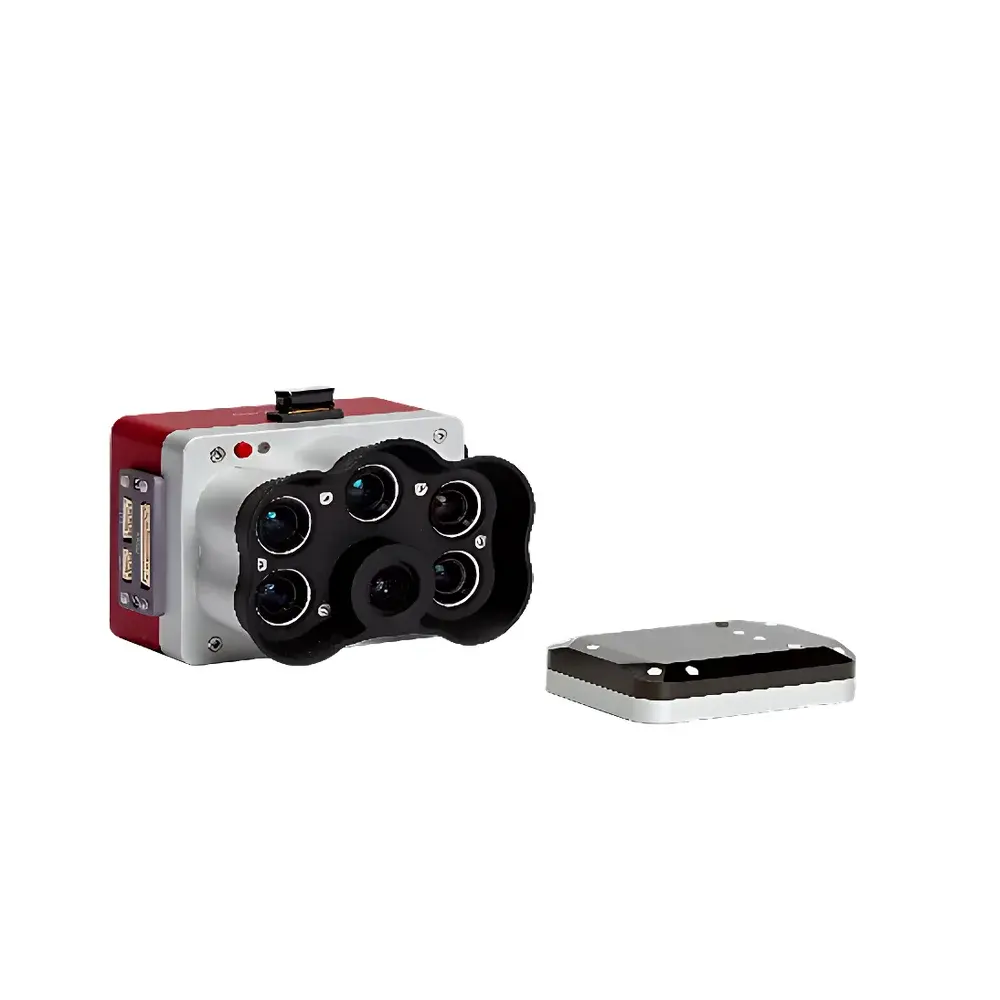
MicaSense RedEdge-P Multispectral Camera
| Brand | MicaSense |
|---|---|
| Origin | USA |
| Manufacturer Status | Authorized Distributor |
| Import Status | Imported |
| Model | RedEdge-P |
| Price Range | USD 6,800 – 13,600 (est. based on ¥50,000–100,000 at 7.35 CNY/USD) |
| Weight | 350 g (incl. DLS2) |
| Dimensions | 8.9 × 7.0 × 6.7 cm |
| Input Voltage | 7–25.2 V DC |
| Power Consumption | 5.5 W (standby), 7.0 W (average), 10 W (peak) |
| Spectral Bands | Blue (475 nm), Green (560 nm), Red (668 nm), Red Edge (717 nm), Near-Infrared (842 nm) |
| RGB Output | 5.1 MP global shutter, radiometrically aligned with multispectral bands |
| Multispectral Sensor Resolution | 1.6 MP per band |
| Panchromatic Resolution | 5.1 MP |
| Spatial Resolution | 7.7 cm/pixel @ 120 m (multispectral), 3.98 cm/pixel @ 120 m (panchromatic) |
| Frame Rate | 3 Hz (RAW DNG) |
| Storage | CF card |
| FOV | 50° H × 38° V (multispectral), 44° H × 38° V (panchromatic) |
| Interfaces | 3× GPIO (trigger in, top-of-frame out, 1 PPS out), push-button control, UART serial, USB 2.0 (for Wi-Fi module), 10/100/1000 Ethernet, CF card slot |
Overview
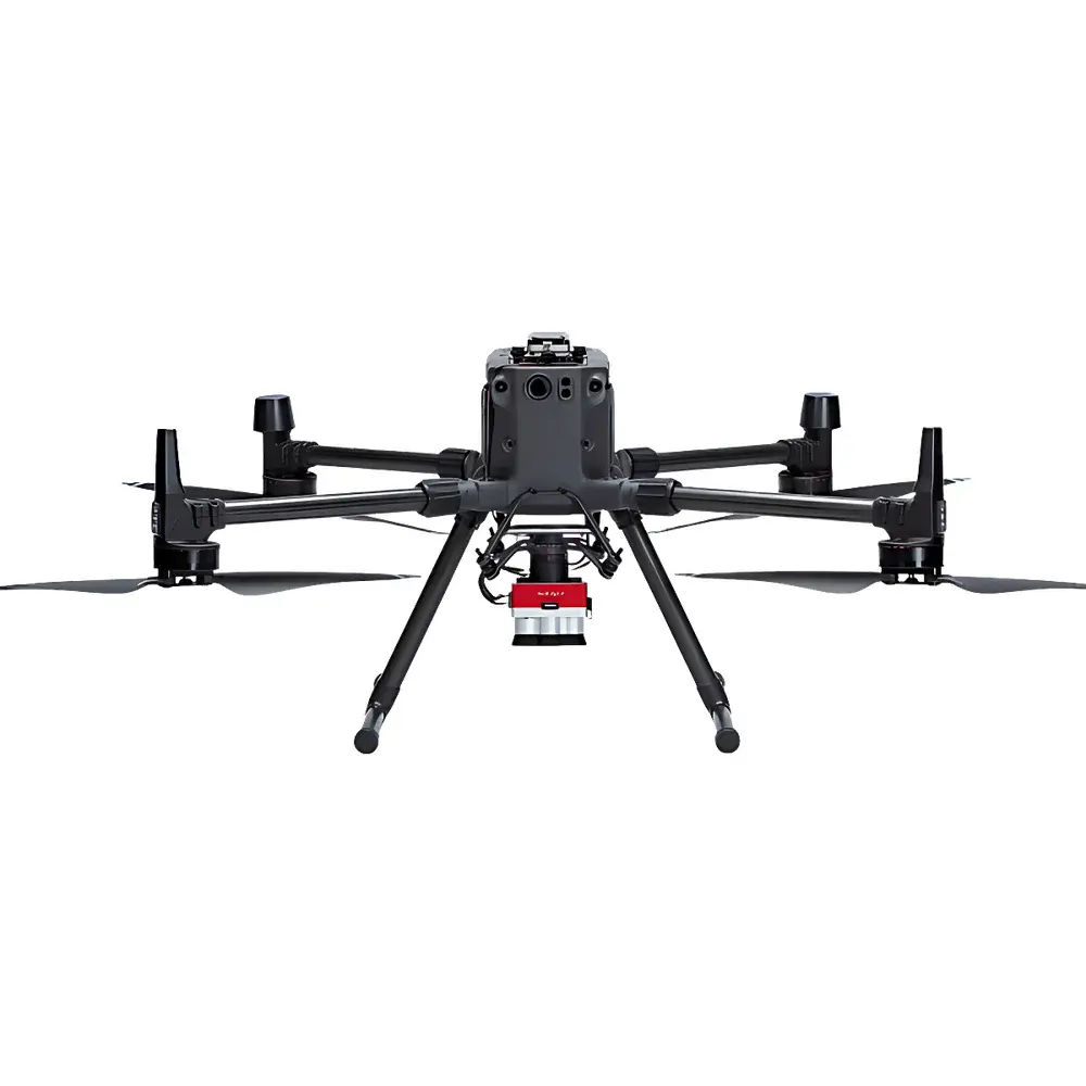
The MicaSense RedEdge-P Multispectral Camera is a precision-engineered remote sensing instrument designed for high-fidelity ecological and environmental monitoring from unmanned aerial platforms. Built upon the proven optical architecture of the RedEdge series, the RedEdge-P integrates a calibrated panchromatic RGB sensor alongside five discrete-band multispectral imagers—each equipped with narrowband interference filters and scientific-grade CMOS detectors. Its measurement principle relies on synchronized, co-boresighted acquisition of reflectance data across five vegetative spectral regions (475, 560, 668, 717, and 842 nm), enabling robust calculation of vegetation indices such as NDVI, NDRE, and CIred-edge with sub-pixel geometric registration accuracy. Unlike consumer-grade RGB-NIR hybrids, the RedEdge-P delivers radiometrically calibrated, geotagged DNG files traceable to NIST-traceable reference panels, supporting quantitative analysis under variable illumination conditions. Its compact form factor (8.9 × 7.0 × 6.7 cm), low mass (350 g with integrated DLS2 downwelling light sensor), and wide input voltage range (7–25.2 V DC) make it compatible with fixed-wing, VTOL, and multirotor UAVs used in operational environmental surveys.
Key Features
- Co-aligned panchromatic RGB (5.1 MP) and multispectral (1.6 MP per band) imaging system with pixel-level correspondence across all six channels
- Enhanced spatial resolution: 3.98 cm/pixel panchromatic GSD at 120 m AGL; 2 cm/pixel RGB-equivalent resolution achievable at 60 m AGL via super-resolution processing
- Integrated DLS2 (Downwelling Light Sensor) for real-time irradiance compensation and improved radiometric consistency across flight lines and diurnal cycles
- Global shutter operation across all bands eliminates motion blur during high-speed UAV operations
- Onboard CF card storage supporting sustained 3 Hz RAW DNG capture with embedded GPS, IMU, and exposure metadata
- Ruggedized aluminum housing rated for operation in ambient temperatures from –10 °C to +50 °C and vibration profiles compliant with MIL-STD-810G
Sample Compatibility & Compliance
The RedEdge-P is optimized for acquisition over terrestrial vegetative surfaces—including agricultural fields, forest canopies, wetlands, and reclaimed industrial sites—where spectral contrast in the red edge and near-infrared regions provides discriminative power for plant health, stress detection, and species classification. It complies with ISO 18436-1 (condition monitoring and diagnostics of machines) for sensor stability verification and supports traceable calibration workflows aligned with ASTM E2593 (Standard Practice for On-Site Calibration of Multispectral Imaging Sensors). While not certified for medical or aviation-critical applications, its radiometric output meets GLP-aligned documentation requirements for environmental impact assessments submitted to EPA, USDA NRCS, and EU Copernicus-partner institutions. Data provenance is maintained through embedded EXIF tags containing UTC timestamps, GPS coordinates, barometric altitude, and sensor temperature—enabling audit-ready chain-of-custody reporting.
Software & Data Management
Data acquisition and post-processing are supported by MicaSense’s enterprise-grade software suite, including FlightControl (mission planning with automated overlap optimization), Atlas (cloud-based orthomosaic generation with atmospheric correction), and AgVault (on-premise processing with batch NDVI/NDRE/CIred-edge export). All outputs conform to GDAL-compliant GeoTIFF standards with embedded RPC metadata, facilitating integration into QGIS, ArcGIS Pro, ENVI, and ERDAS IMAGINE environments. The RedEdge-P supports FDA 21 CFR Part 11–compliant audit trails when deployed with validated workflow configurations—specifically for regulated agronomic trials requiring electronic records retention. Firmware updates are delivered via signed OTA packages, ensuring cryptographic integrity and version-controlled device configuration.
Applications
- Precision agriculture: In-season crop vigor mapping, nitrogen use efficiency modeling, and yield prediction using time-series NDVI and red-edge index trends
- Ecological restoration monitoring: Quantitative assessment of native species establishment, invasive plant encroachment, and soil surface stabilization post-disturbance
- Wetland delineation and hydrological modeling: Discrimination of emergent macrophytes, submerged aquatic vegetation, and turbidity gradients via spectral unmixing
- Forestry inventory and disturbance detection: Crown-level LAI estimation, defoliation tracking following pest outbreaks (e.g., emerald ash borer), and burn severity classification post-wildfire
- Regulatory compliance reporting: Generation of repeatable, calibrated imagery for EPA NPDES permit verification, USACE jurisdictional determinations, and EU Habitats Directive monitoring programs
FAQ
Does the RedEdge-P require external calibration targets during every flight?
No. While reflectance panels are recommended for absolute radiometric calibration in critical applications, the integrated DLS2 enables relative normalization across flights without panel deployment.
Can the RedEdge-P be triggered externally via PWM or TTL signals?
Yes. It supports hardware triggering via GPIO pin (active-low TTL-compatible) with configurable exposure delay and burst mode settings.
Is the Ethernet interface capable of real-time video streaming?
No. The 10/100/1000 Ethernet port is dedicated to firmware updates, configuration transfer, and high-throughput bulk DNG download—not live telemetry or video.
What spectral resampling options are available in Atlas for index computation?
Atlas applies sensor-specific spectral response function (SRF) convolution prior to index derivation, preserving physical meaning across platforms and avoiding generic band-ratio approximations.
How is geometric distortion corrected in RedEdge-P imagery?
Each unit undergoes factory-based lens distortion characterization using checkerboard and dot-pattern targets; coefficients are embedded in image metadata and applied automatically during orthorectification in supported photogrammetry engines.
Related Products


