Optosky MV-FS Field-Scanning Hyperspectral Imaging System
| Brand | Optosky |
|---|---|
| Model | MV-FS |
| Instrument Type | Push-broom Hyperspectral Imager |
| Operating Environment | Ground-based (Field & Lab) |
| Spectral Range | 400–1000 nm |
| Spectral Resolution | 6 nm (FWHM) |
| Spectral Sampling Interval | 1.75 nm/pixel |
| Spatial Pixels | 1024 |
| Spectral Bands | 342 |
| Optical Design | All-reflective concentric aberration-corrected |
| Grating Type | Convex holographic diffraction grating |
| Detector | CMOS |
| A/D Resolution | 12-bit |
| Interface | USB 3.1 |
| Max Frame Rate | >100 Hz |
| Power Supply | 5 V DC / 2.4 W (max) |
| Weight (body only) | 0.3 kg |
| Dimensions | 64 × 50 × 38 mm |
| Aperture | f/2.5 |
Overview
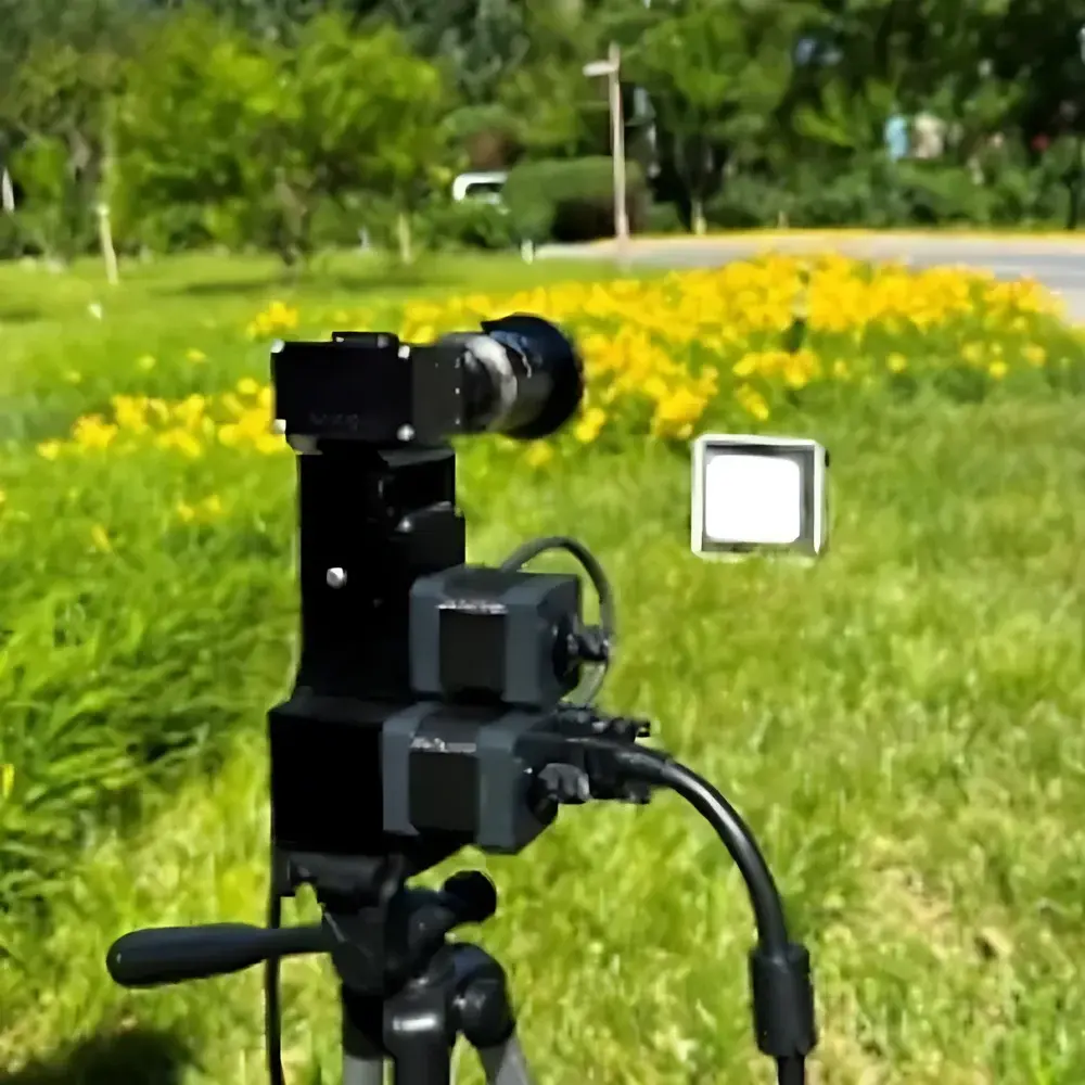
The Optosky MV-FS Field-Scanning Hyperspectral Imaging System is a compact, high-performance push-broom hyperspectral imager engineered for ground-based spectral data acquisition in both field and laboratory environments. It operates on the principle of spatial-scan spectral dispersion: as the system moves linearly across a target—either via integrated precision rotary stage or manual translation—it captures one spatial line per integration time, with full spectral information (342 bands) resolved simultaneously across the 1024-pixel linear array. The optical architecture employs an all-reflective concentric design with integrated aberration correction, eliminating chromatic distortion and ensuring consistent point spread function (PSF) across the entire 400–1000 nm spectral range. Coupled with a convex holographic diffraction grating and f/2.5 aperture, the system achieves high throughput and signal-to-noise ratio (SNR), critical for low-light outdoor operation and quantitative reflectance measurement. Its lightweight construction (0.3 kg body mass), USB 3.1 interface, and 5 V DC power compatibility enable seamless integration into portable survey platforms—including drone-mounted configurations (with appropriate stabilization and calibration)—while maintaining metrological integrity under variable ambient conditions.
Key Features
- Push-broom scanning architecture optimized for ground-level mapping with sub-meter spatial sampling at typical working distances (1–10 m)
- All-reflective concentric optical path with holographic convex grating—no transmissive optics to induce thermal drift or spectral shift
- 12-bit CMOS detector delivering 342 contiguous spectral channels with 1.75 nm sampling interval and 6 nm FWHM spectral resolution
- Compact form factor (64 × 50 × 38 mm) and ultra-low mass (0.3 kg, excluding lens) enabling rapid deployment on rotary stages, UAV gimbals, or handheld rigs
- USB 3.1 Gen 1 interface supporting real-time streaming at >100 Hz frame rate; driver-level API support (C/C++, Python) for custom acquisition logic and synchronization
- Integrated power management compatible with external lithium battery packs (5 V, ≥2.5 A), sustaining >4 hours of continuous operation in field mode
Sample Compatibility & Compliance
The MV-FS is designed for non-contact, passive reflectance imaging of natural and engineered surfaces under solar illumination or controlled broadband lighting. It supports standardized radiometric calibration workflows using NIST-traceable reflectance panels (e.g., Spectralon®) and dark-current reference acquisition. Data output conforms to ENVI-compatible BIL (Band Interleaved by Line) format with embedded wavelength and metadata headers (including GPS timestamp, IMU orientation if externally synchronized). While not certified for regulated clinical or pharmaceutical use, the system adheres to general-purpose instrumentation principles aligned with ISO 17025 foundational requirements for measurement traceability. Its spectral fidelity enables compliance with ASTM E2798 (Standard Practice for Determining Spectral Reflectance Factors of Opaque Specimens Using Spectrophotometers) when used with calibrated illumination and geometry control.
Software & Data Management
The MV-FS ships with Optosky’s native Windows-based acquisition software featuring real-time preview, ROI selection, exposure auto-adjustment, and batch geotagging. Raw data files include full header information: acquisition time (UTC), integration time, sensor temperature, and user-defined project tags. Export options include ENVI .hdr/.dat, GeoTIFF (with optional georeferencing), and CSV spectral profiles. The SDK provides documented C++ and Python bindings for integration into larger analytical pipelines—e.g., coupling with scikit-learn for supervised classification or PyTorch for CNN-based material segmentation. All software modules maintain audit-ready logging (user actions, parameter changes, calibration events) satisfying GLP-aligned documentation practices for academic and environmental monitoring applications.
Applications
- Agriculture & Forestry: Quantitative assessment of vegetation indices (NDVI, PRI, MCARI), chlorophyll-a/b estimation, nitrogen status mapping, and early-stage stress detection (drought, pest infestation)
- Environmental Monitoring: Discrimination of algal bloom species in inland waters, suspended sediment concentration modeling, soil organic carbon and iron oxide mapping
- Urban Remote Sensing: Asphalt degradation analysis, impervious surface classification, tree species inventory, and post-event damage assessment (e.g., flood or fire)
- Geoscience: Mineralogical identification (e.g., kaolinite, hematite, goethite) via spectral absorption feature matching; lithological boundary delineation
- Cultural Heritage: Non-invasive pigment identification in mural paintings and historical manuscripts; differentiation of binding media and substrate aging signatures
- Industrial QA: Real-time sorting of recyclables (plastics, metals), detection of coating uniformity, and counterfeit material screening
FAQ
What spectral calibration standards are supported?
The MV-FS supports factory spectral calibration using mercury-argon lamp lines and user-performed wavelength recalibration via reflective standard targets. Certified calibration reports traceable to NIST SRM 2035 are available upon request.
Can the system be mounted on a UAV platform?
Yes—its mass, power profile, and USB 3.1 interface make it suitable for integration with stabilized gimbal systems; however, motion blur compensation requires external IMU synchronization and post-processing orthorectification.
Is radiometric calibration included in the base package?
A basic reflectance panel (99% Spectralon®) and dark-cap are supplied; absolute radiometric calibration (requiring integrating sphere and calibrated light source) is offered as an optional service.
Does the software comply with FDA 21 CFR Part 11 requirements?
The standard acquisition software does not include electronic signature or audit trail features required for Part 11 compliance; however, raw data export enables integration into validated LIMS or ELN platforms that do.
How is geometric distortion corrected in field data?
The all-reflective concentric design inherently minimizes keystone and smile distortion; residual effects are corrected during processing using polynomial warping models derived from checkerboard or pinhole calibration targets.