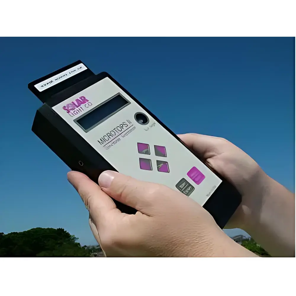
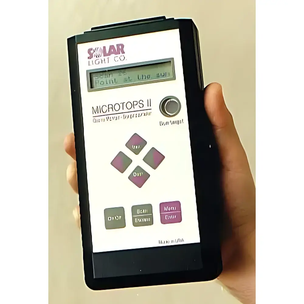
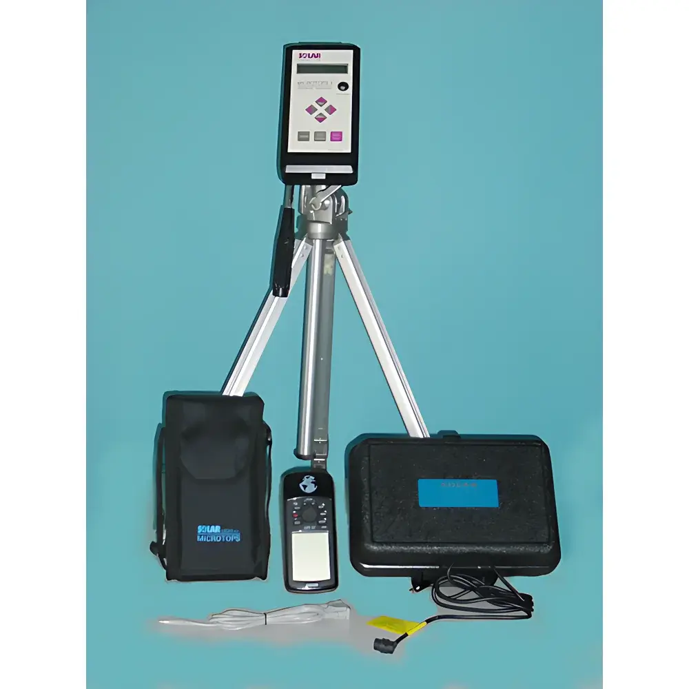
Solar Light Microtops II Handheld Sun Photometer
| Brand | Solar Light |
|---|---|
| Origin | USA |
| Model | Microtops II |
| Optical Channels | 340, 380, 440, 500, 675, 870, 936, 1020 nm (user-selectable 5-channel configuration) |
| Spectral Bandwidth (FWHM) | 2–10 nm depending on channel |
| Stray Light Rejection | ≤1×10⁻⁶ (λ < 650 nm), ≤1×10⁻⁵ (λ < 1.2 µm) |
| Dynamic Range | >300,000 |
| Radiometric Resolution | 0.1 W/m² |
| Field of View | 2.5° |
| Accuracy | ±1–2% |
| Nonlinearity | ≤0.002% FS |
| Operating Temperature | 0–50 °C, no precipitation |
| Power | 4×AA alkaline batteries |
| Weight | 600 g |
| Dimensions | 10 × 20 × 4.3 cm |
| Interface | RS-232C |
| Data Storage | Non-volatile memory with timestamp, GPS coordinates (optional), solar zenith angle, altitude, pressure, temperature |
| Software | MICROTOPS Organizer (Windows-based data retrieval and archiving) |
Overview
The Solar Light Microtops II Handheld Sun Photometer is a field-deployable, precision optical instrument engineered for the quantitative measurement of direct solar irradiance across discrete spectral bands to derive aerosol optical thickness (AOT), columnar water vapor, and total ozone. Based on the principle of Langley regression and Beer–Lambert extinction analysis, the Microtops II operates by measuring attenuation of solar radiation at multiple wavelengths—each selected to target specific atmospheric absorbers (e.g., ozone at 340 nm, water vapor at 936/870/1020 nm, and aerosol scattering at 440/500/675 nm). Its compact, self-contained design enables high-fidelity atmospheric profiling without reliance on external power or computing infrastructure—making it ideal for remote field campaigns, long-term monitoring networks, and educational deployment where portability and operational simplicity are critical.
Key Features
- High metrological fidelity: Incorporates NIST-traceable interference filters with tight center-wavelength tolerances (±0.3–1.5 nm) and narrow full-width half-maximum (FWHM) bandwidths (2–10 nm), ensuring spectral purity and minimizing cross-channel contamination.
- Low-noise analog electronics: Features a 20-bit analog-to-digital converter and optimized low-drift amplification circuitry, delivering high linearity (>99.998% FS), wide dynamic range (>300,000), and radiometric resolution of 0.1 W/m².
- Integrated environmental metadata logging: Records time-stamped measurements with solar zenith angle, GPS-derived latitude/longitude (with optional GPS receiver), altitude, barometric pressure, and ambient temperature—enabling rigorous atmospheric correction and traceable data provenance.
- Onboard real-time computation: Embedded algorithms compute AOT, columnar water vapor (using 936/870/1020 nm combinations), and total ozone directly in the device; results are displayed instantaneously on the LCD screen and stored with raw irradiance values.
- Robust field operation: Designed for ambient use between 0–50 °C with no condensation or precipitation exposure required; powered by standard AA alkaline cells providing >10 hours of continuous operation under typical field conditions.
- Flexible spectral configuration: Supports user-defined selection of any five channels from eight standardized WMO-recommended wavelengths (340, 380, 440, 500, 675, 870, 936, 1020 nm), including custom filter sets for specialized research applications.
Sample Compatibility & Compliance
The Microtops II is optimized for clear-sky, direct-sun measurements under ISO 9060:2018 Class C spectral irradiance conditions and complies with WMO/GAW recommendations for manual sun photometry. It meets ASTM D854-22 requirements for field-deployable optical extinction instruments used in atmospheric transparency assessment. Data output conforms to AERONET-compatible ASCII format (including SZA, AOT, and ancillary metadata), facilitating interoperability with global aerosol databases. The instrument supports GLP-aligned workflows through timestamped, non-volatile storage and optional GPS georeferencing—critical for regulatory monitoring programs requiring audit-ready records per EPA Method IO-3.1 and EU Directive 2008/50/EC Annex IX.
Software & Data Management
MICROTOPS Organizer is a Windows-native application enabling automated data download via RS-232 interface, batch processing, spectral calibration verification, and export to CSV or NetCDF formats. The software includes built-in Langley plot diagnostics, AOT uncertainty estimation based on measurement repeatability and solar geometry, and configurable reporting templates aligned with GAW and AERONET submission standards. All raw irradiance and derived parameters are stored with immutable timestamps and environmental context—supporting 21 CFR Part 11-compliant electronic record integrity when paired with appropriate system validation protocols.
Applications
- Long-term aerosol optical depth monitoring at meteorological stations and GAW regional observatories
- Validation of satellite-derived AOT products (e.g., MODIS, VIIRS, TROPOMI) through ground-truth campaigns
- Urban and industrial air quality assessment—correlating AOT trends with PM₂.₅/PM₁₀ mass concentrations
- Climate research: quantifying aerosol radiative forcing components and cloud–aerosol interaction studies
- UV index and erythemal dose modeling using 340/380 nm channels
- Calibration and validation of hyperspectral imagers and radiometric sensors deployed on UAVs or ground-based platforms
- Undergraduate and graduate atmospheric science laboratories—teaching radiative transfer, atmospheric optics, and instrumentation principles
FAQ
What atmospheric parameters can the Microtops II directly calculate?
It computes aerosol optical thickness (AOT) at each selected wavelength, column-integrated water vapor (using 936/870/1020 nm triplets), and total ozone column (using 340/380 nm dual-band ratio method).
Is GPS integration mandatory for accurate AOT calculation?
No—GPS is optional but strongly recommended for georeferencing, solar geometry refinement, and compliance with AERONET metadata standards. Latitude, longitude, and altitude may be entered manually.
How does the Microtops II ensure long-term calibration stability?
Each unit ships with factory-applied NIST-traceable calibration coefficients; users perform routine field checks using Langley plots under stable atmospheric conditions. Annual recalibration is advised for GLP/GMP environments.
Can the Microtops II operate under cloudy conditions?
No—it requires unobstructed direct-sun viewing. Cloud screening is implemented automatically via real-time solar signal variance detection; measurements with excessive scatter are flagged and excluded from analysis.
What data format is generated, and how is traceability maintained?
ASCII-formatted output includes raw voltage counts, computed AOTs, solar zenith angle, timestamp, location, pressure, temperature, and instrument ID—enabling full chain-of-custody documentation per ISO/IEC 17025:2017 requirements.
Related Products


