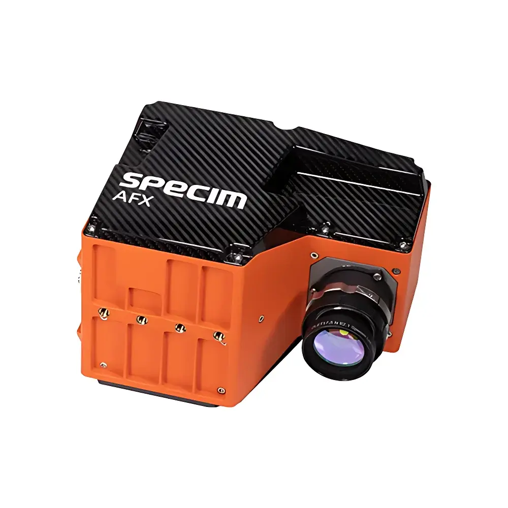
Specim AFX & AISA Airborne Hyperspectral Imaging Systems
| Brand | Specim (Finland) |
|---|---|
| Model | Specim AFX10 / AFX17 & AisaFENIX 1K |
| Spectral Range | 400–1000 nm (AFX10), 900–1700 nm (AFX17), 400–2500 nm (AisaFENIX 1K) |
| Spectral Resolution | 5.5 nm (AFX10), 8.0 nm (AFX17), <10 nm (AisaFENIX 1K) |
| Spatial Resolution | 1024 px (AFX10), 640 px (AFX17), 1024 px (AisaFENIX 1K) |
| FOV | 40° |
| IFOV | 0.039° |
| Frame Rate | 330 fps (AFX10), 670 fps (AFX17), up to 300 fps (AisaFENIX 1K) |
| Weight | 2.1 kg (AFX10), 2.4 kg (AFX17), ~30 kg (AisaFENIX 1K) |
| Integrated GNSS/IMU | Yes, with PPS synchronization, 1 Hz position update, 50 Hz altitude update, post-processing capable via POSPAC UAV |
| Optical Design | Fixed-focus, pre-characterized lens distortion correction provided |
| Data Acquisition Mode | Mission-driven autonomous capture with georeferenced metadata embedding |
| Compliance | Designed for ISO 19115-compliant geospatial metadata generation |
Overview
The Specim AFX and AisaFENIX 1K airborne hyperspectral imaging systems represent two complementary tiers of push-broom spectral sensing platforms engineered for quantitative remote sensing from unmanned aerial vehicles (UAVs) and manned aircraft. The AFX series—comprising the AFX10 (400–1000 nm) and AFX17 (900–1700 nm)—is a compact, integrated solution optimized for small-to-medium UAV deployment. Its core architecture combines a high-speed line-scan imager, embedded real-time GNSS/IMU navigation unit, and onboard preprocessing CPU in a single enclosure weighing under 2.4 kg. In contrast, the AisaFENIX 1K is a full-spectrum VNIR-SWIR sensor (400–2500 nm) designed for medium-altitude manned platform operation, delivering 1024 spatial pixels across its entire spectral range with thermally stabilized optics and co-aligned fore-optics to eliminate inter-band misregistration. Both systems operate on the principle of spatially resolved spectral dispersion using transmissive prism-grating optics and scientific-grade CMOS or InGaAs detector arrays, enabling pixel-wise reflectance calibration and radiometric traceability per EN 13032-4 and ISO/TR 22220.
Key Features
- Integrated GNSS/IMU subsystem with 1 Hz position, 50 Hz altitude, and PPS-synchronized timestamping—enabling centimeter-level post-processed kinematic (PPK) positioning when used with POSPAC UAV software
- Pre-characterized optical distortion model delivered with each unit, supporting rigorous geometric correction without field calibration
- High photon throughput design (f/1.7 aperture) combined with adaptive gain control and non-uniformity correction algorithms for consistent radiometric fidelity across varying illumination conditions
- Autonomous mission-based acquisition: flight path waypoints trigger synchronized image capture, GNSS logging, and IMU sampling—reducing operator dependency and ensuring repeatable data collection protocols
- Multi-ROI spectral selection capability: users define custom spectral band subsets per acquisition task, minimizing data volume while preserving application-specific discriminants
- Unified mechanical and electrical integration: all components—including cooling, power regulation, and telemetry interfaces—are housed in a single ruggedized aluminum chassis compliant with MIL-STD-810G environmental specifications
- Cross-platform compatibility: AFX units mount directly to multirotor and fixed-wing UAVs without gimbals; AisaFENIX 1K supports integration with stabilized turrets and gyro platforms per STANAG 4671 interface profiles
Sample Compatibility & Compliance
These systems are not sample-contact instruments but rather passive, non-invasive remote sensors that acquire reflected solar radiation from terrestrial and aquatic surfaces. Their spectral coverage aligns with key absorption features of chlorophyll-a (680 nm), water vapor (940 nm), cellulose (1200 nm), lignin (1680 nm), and hydrocarbons (2300–2500 nm), making them suitable for vegetation biophysical parameter retrieval (e.g., LAI, Cab, Cw), soil organic carbon estimation, and mineralogical mapping. All systems comply with ISO 19115 metadata standards and support automated embedding of geolocation, attitude, exposure time, and radiometric gain settings into raw data headers. For regulated applications—including environmental monitoring under EU INSPIRE directives or US EPA Tier-3 assessment frameworks—the AFX and AisaFENIX platforms support audit-trail-enabled data processing pipelines compatible with GLP-aligned validation procedures.
Software & Data Management
Raw data output follows the Specim proprietary .bil/.hdr format (BSQ-interleaved, IEEE 754 float32), fully interoperable with ENVI, QGIS, Python (scikit-image, spectral), and MATLAB hyperspectral toolboxes. The included Specim Insight software provides real-time preview, basic radiometric correction (dark current subtraction, flat-field normalization), and georeferencing using onboard GNSS/IMU logs. For advanced processing—including atmospheric correction (QUAC, FLAASH), endmember extraction (N-FINDR), and classification (SVM, Random Forest)—the systems integrate natively with PCI Geomatica, Exelis ENVI, and the open-source HyTools library. All metadata adhere to the OGC SensorML schema and can be ingested into enterprise geospatial data infrastructures supporting ISO/IEC 11179 registries. No cloud-based processing or vendor-locked subscriptions are required; raw data remain fully accessible and portable across analytical environments.
Applications
- Vegetation species mapping and invasive species detection using spectral unmixing of canopy-level reflectance signatures
- Quantitative chlorophyll and nitrogen content estimation in precision agriculture—supporting variable-rate fertilization in accordance with ISO 11783-10
- Water quality assessment: suspended sediment concentration (SSC), chlorophyll-a, and CDOM retrieval from coastal and inland waters
- Post-wildfire burn severity classification (dNBR) and regrowth monitoring at sub-hectare resolution
- Soil moisture and salinity mapping via SWIR water absorption band ratios (1450/1900 nm)
- Mineral exploration targeting clay, carbonate, and sulfide alteration zones through diagnostic absorption features in the 2100–2500 nm range
- Environmental compliance monitoring: landfill leachate plume detection, oil spill delineation, and illegal mining activity identification
- Defense and security applications including camouflage detection, concealed object identification, and forensic land-use change analysis
FAQ
What is the primary difference between the AFX and AisaFENIX 1K systems?
The AFX series is a lightweight, UAV-optimized platform with dual-band variants (VNIR or SWIR only), while AisaFENIX 1K delivers continuous full-spectrum coverage (400–2500 nm) and higher spatial fidelity, requiring manned aircraft due to its mass and thermal management requirements.
Do these systems support radiometric calibration in-flight?
No real-time absolute radiometric calibration is performed onboard; however, each system ships with factory-derived radiometric response curves and dark reference frames, enabling post-acquisition calibration against ground-based reference panels per ASTM E2909-22 Annex B.
Can AFX data be processed without proprietary software?
Yes—raw data are stored in open binary formats with human-readable header files containing all essential acquisition parameters, allowing full reproducibility in open-source environments.
Is PPK processing mandatory for georeferencing?
No; SBAS-corrected GNSS provides ~1.5 m horizontal accuracy, but PPK with base station data improves this to ≤5 cm—recommended for applications requiring sub-pixel registration across time-series datasets.
Are firmware updates and technical documentation available to end users?
Yes—Specim provides publicly accessible firmware releases, user manuals, spectral response function (SRF) datasets, and lens distortion models via their official support portal, with no licensing restrictions on archival or derivative use.