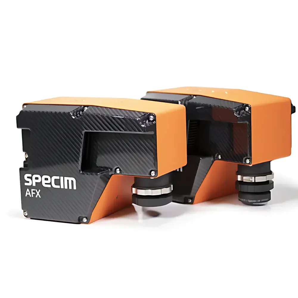
Specim AFX Series Airborne Hyperspectral Imaging Solution
| Brand | Specim (Finland) |
|---|---|
| Origin | Finland |
| Model | AFX10 / AFX17 |
| Spectral Range | AFX10 — 400–1000 nm (Vis-NIR), AFX17 — 900–1700 nm (NIR) |
| Spatial Resolution | Up to 1280 pixels across track |
| Frame Rate | Up to 300 fps (configurable) |
| Integration | GNSS/IMU-aided georeferencing |
| Platform Compatibility | UAVs (multirotor, fixed-wing), light aircraft |
| Onboard Processing | Embedded real-time data acquisition & preprocessing unit |
| Data Output Format | ENVI-compatible raw and radiometrically calibrated cubes (.bil/.hdr) |
| Weight | < 2.5 kg (full integrated system) |
Overview
The Specim AFX Series represents a purpose-engineered airborne hyperspectral imaging solution designed for high-fidelity remote sensing from unmanned aerial vehicles (UAVs) and light manned platforms. Built upon Specim’s proven line-scan push-broom imaging architecture, the AFX systems operate on the principle of spectral dispersion via transmission gratings coupled with high-quantum-efficiency CMOS or InGaAs sensor arrays. Each model—AFX10 and AFX17—is optimized for distinct spectral domains: the AFX10 covers the visible to near-infrared range (400–1000 nm) with ~2.5 nm spectral sampling, while the AFX17 operates in the shortwave infrared (900–1700 nm) at ~5 nm resolution. Both systems integrate synchronized acquisition of spatial, spectral, and positional metadata via embedded GNSS/IMU units compliant with RTK-grade positioning accuracy (< 10 cm horizontal, < 15 cm vertical under optimal conditions). The onboard processing unit performs real-time radiometric correction, dark current subtraction, and geometric rectification—enabling immediate generation of georeferenced, radiometrically calibrated hyperspectral datacubes without post-mission ground station dependency.
Key Features
- Modular airborne architecture: Fully integrated HSI camera, ruggedized onboard computer, and dual-antenna GNSS/IMU in a single lightweight enclosure (< 2.5 kg)
- Push-broom imaging with mechanical stabilization: Minimizes motion-induced spectral smearing during dynamic flight operations
- Real-time onboard calibration: Automatic non-uniformity correction (NUC), dark frame compensation, and flat-field normalization applied during acquisition
- Configurable acquisition parameters: Adjustable integration time, line rate, and region-of-interest (ROI) selection via Ethernet or serial interface
- ENVI- and HDF5-compliant output: Raw and calibrated data exported as band-interleaved-by-line (BIL) files with full metadata embedding (wavelength, FWHM, GPS timestamp, attitude quaternions)
- Thermal management system: Passive and active cooling ensures stable sensor response across ambient temperatures from −10°C to +45°C
Sample Compatibility & Compliance
The AFX Series is not sample-contacting; it acquires reflected solar radiation from terrestrial and aquatic surfaces at altitudes ranging from 30 m to 1200 m AGL. Its optical design supports consistent data collection over heterogeneous natural targets—including vegetation canopies, soil substrates, inland water bodies, and snow/ice surfaces—under variable illumination and atmospheric conditions. All systems comply with EU CE marking requirements for electromagnetic compatibility (EMC Directive 2014/30/EU) and radio equipment (RED 2014/53/EU). Data handling workflows align with ISO 19115-2:2019 metadata standards and support traceability for GLP-aligned environmental monitoring programs. While not FDA-regulated, the radiometric calibration protocols follow NIST-traceable procedures documented per ISO/IEC 17025:2017 requirements for measurement uncertainty reporting.
Software & Data Management
Specim delivers the AFX Control Suite—a cross-platform application (Windows/Linux) for mission planning, real-time telemetry monitoring, and live preview of spectral profiles. Raw data are processed using Specim’s proprietary CaliCube software, which applies sensor-specific radiometric models, atmospheric correction (via MODTRAN-based lookup tables), and orthorectification using external DEMs. Exported cubes are directly ingestible into ENVI, Python (scikit-image, spectral), R (hsdar), and MATLAB environments. Audit trails—including acquisition parameters, calibration history, and GNSS/IMU status logs—are embedded in HDF5 containers and support 21 CFR Part 11–compliant electronic signatures when deployed within validated laboratory information management systems (LIMS).
Applications
- Vegetation phenotyping: Quantification of chlorophyll-a/b, carotenoids, and water content indices (e.g., NDWI, NDVI, PRI) at plot and landscape scales
- Agricultural resource management: Mapping soil moisture gradients, nitrogen status, and lime requirement zones for precision fertilization
- Wetland biogeochemistry: Discrimination of emergent macrophyte species, detection of submerged aquatic vegetation, and estimation of dissolved organic carbon in shallow waters
- Wildlife habitat assessment: Identification of thermal refugia, mapping of riparian corridors, and detection of invasive plant encroachment
- Post-wildfire recovery monitoring: Burn severity classification (dNBR), char layer thickness estimation, and early regrowth detection using SWIR spectral absorption features
FAQ
What spectral calibration standards are used for factory calibration?
Factory calibration employs NIST-traceable tungsten-halogen and deuterium lamps, with wavelength accuracy verified against atomic emission lines (Hg, Ne, Ar). Radiometric calibration uses integrating sphere sources with certified spectral radiance values.
Can the AFX system be operated without GNSS/IMU input?
Yes—though georeferencing accuracy degrades significantly. Systems default to time-stamped raw cube output with optional external PPS synchronization for third-party navigation solutions.
Is radiometric recalibration required in the field?
No routine recalibration is needed between flights; however, users may perform quick-check dark/white reference acquisitions before each mission to account for thermal drift or lens contamination.
Which UAV platforms have been validated for AFX integration?
Validated platforms include DJI Matrice 300 RTK, Freefly Alta X, Quantum-Systems Trinity F90+, and SenseFly eBee X—subject to payload mounting interface and power delivery specifications (24–36 V DC, ≤ 120 W peak).
Does Specim provide spectral library support for material identification?
Specim supplies the Specim Spectral Library (SSL), containing >1,200 reference spectra of soils, minerals, vegetation, and man-made materials, compatible with ENVI’s Spectral Analyst and custom ML classifiers.