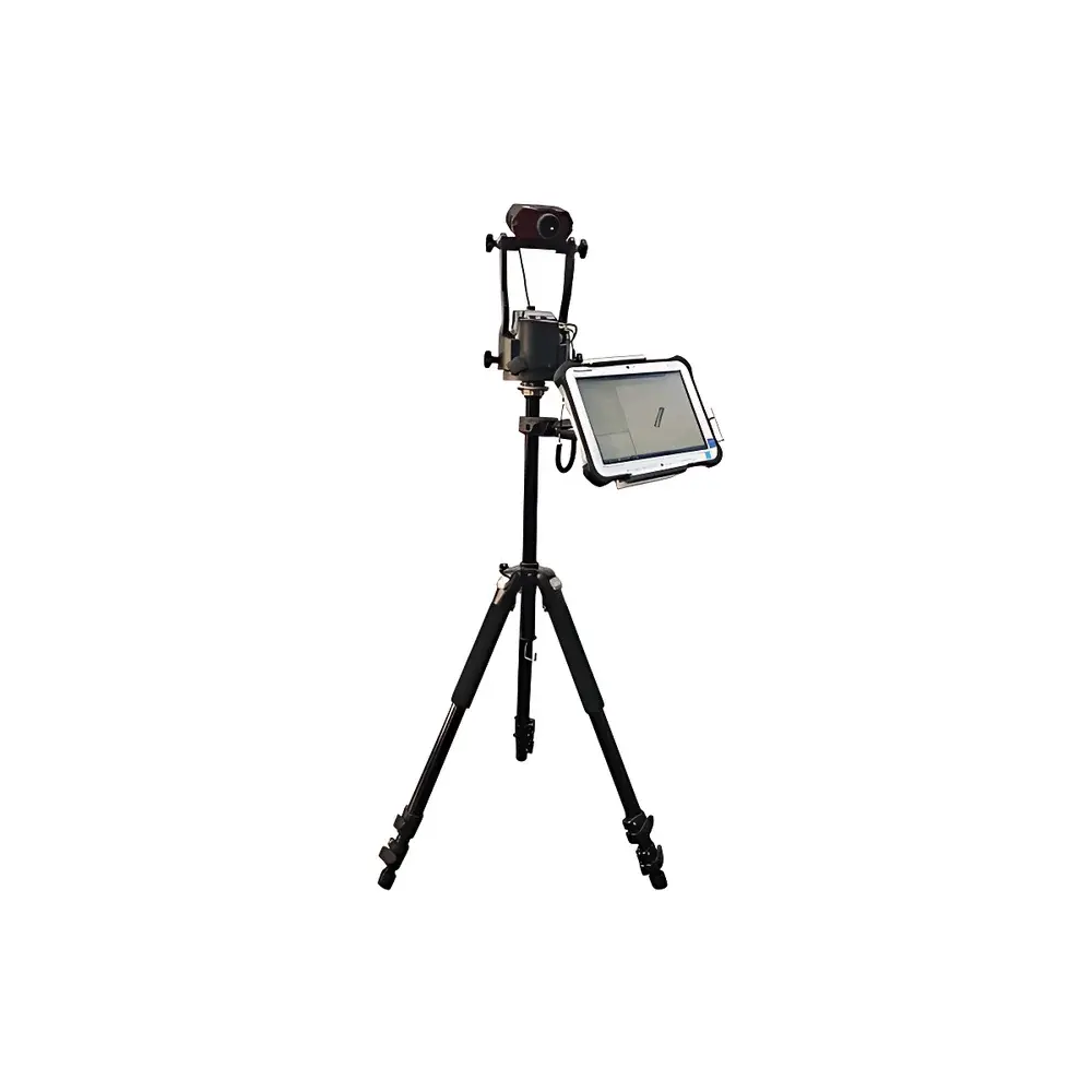
Sundy SDLM300 Portable Coal Stack Analyzer
| Brand | Sundy |
|---|---|
| Model | SDLM300 |
| Origin | Hunan, China |
| Type | Portable 3D Laser-Based Volumetric Measurement System for Bulk Material Stacks |
| Volume Accuracy | ≤1.5% (V < 1000 m³), ≤1.0% (V ≥ 1000 m³) |
| Operating Temperature | −30 °C to +55 °C (laser unit: −30 °C to +60 °C) |
| Battery Life | 4 h (laser rangefinder, single battery), 3 h (rugged tablet, full charge) |
| IP Rating | IP56 |
| Drop Resistance | MIL-STD-810G compliant (tablet) |
| Laser Range | 1900 m (≥10% reflectivity), ±4 cm accuracy (typical target < 400 m) |
| Inclination Measurement | ±85°, ±0.1° resolution |
| Horizontal Angle | 0–360°, ±0.01° resolution |
| Total Unit Weight | ~3.5 kg (varies with tablet/stabilization mount) |
| Compliance | ASTM D6172 (standard practice for volumetric measurement of stockpiles), ISO 11222:2017 (geospatial data quality for volume estimation), GLP-aligned data traceability |
Overview
The Sundy SDLM300 Portable Coal Stack Analyzer is a field-deployable, laser-based 3D volumetric measurement system engineered for rapid, non-contact quantification of bulk material stockpiles—including coal, ore, aggregate, and earthwork volumes—in power plants, coal terminals, metallurgical facilities, and civil infrastructure projects. It operates on the principle of high-precision time-of-flight (ToF) laser distance measurement combined with dual-axis electronic inclinometry and azimuthal orientation tracking. By acquiring dense point-cloud profiles from multiple ground-level stations around a pile, the SDLM300 reconstructs a georeferenced 3D surface model and computes net volume against a user-defined base plane—eliminating reliance on manual surveying, topographic leveling, or aerial photogrammetry. Its design targets operational efficiency in harsh industrial environments, where ambient temperature extremes, dust, moisture, and physical handling stress are routine.
Key Features
- Lightweight modular architecture (~3.5 kg total system mass) enables single-operator deployment without tripods or external power sources—ideal for remote yards and constrained access zones.
- Integrated military-grade rugged tablet (MIL-STD-810G certified) with sunlight-readable display and glove-compatible touchscreen ensures reliable operation under ambient temperatures ranging from −30 °C to +55 °C.
- Laser rangefinder delivers 1900 m maximum range (≥10% reflectivity) with ±4 cm distance accuracy at distances under 400 m, supporting precise edge detection on low-contrast coal surfaces.
- Dual-axis tilt sensor (±85°, ±0.1° resolution) and 360° azimuth encoder (±0.01° resolution) provide real-time spatial orientation correction, critical for accurate triangulation across uneven terrain.
- IP56-rated enclosure protects internal electronics against dust ingress and water jets—validated for continuous use in coal handling facilities with high particulate loading and periodic washdowns.
- Fully menu-driven acquisition software with native Chinese UI reduces training burden; all raw scan data and metadata (timestamp, GPS coordinates if enabled, instrument pose) are logged in standardized binary format for auditability.
Sample Compatibility & Compliance
The SDLM300 is validated for volumetric analysis of heterogeneous, irregularly shaped stockpiles composed of anthracite, bituminous coal, lignite, crushed limestone, blast furnace slag, and excavated overburden. It accommodates pile heights up to 30 m and footprints exceeding 10,000 m² when surveyed using multi-station methodology. All measurement protocols align with ASTM D6172 (“Standard Practice for Volumetric Measurement of Stockpiles Using Surveying Methods”) and support traceable calibration via NIST-traceable laser distance standards. The system’s data logging architecture complies with GLP principles—each volume report includes operator ID, instrument serial number, environmental conditions (temperature, humidity), and full measurement sequence metadata. While not FDA-regulated, its audit trail structure satisfies internal QA requirements for ISO 9001:2015 and ISO/IEC 17025:2017 accredited laboratories performing inventory reconciliation.
Software & Data Management
Data acquisition and post-processing occur within a Windows-based desktop application suite. Raw scan files (.sdm) contain unprocessed distance, angle, and orientation vectors—preserving full metrological fidelity. Volume computation uses Delaunay triangulation and plane-fitting algorithms to generate a TIN (Triangulated Irregular Network) mesh referenced to a user-specified datum plane (e.g., ground elevation, conveyor belt level, or historical baseline). Outputs include ASCII CSV reports with cross-sectional area, cumulative volume, and uncertainty estimates per ASTM D6172 Annex A; DXF and OBJ exports enable integration into AutoCAD, Civil 3D, or GIS platforms. Software enforces role-based access control, automatic timestamping, and immutable log files—supporting 21 CFR Part 11–aligned electronic record integrity when deployed in regulated QA/QC workflows.
Applications
- Real-time coal inventory management at thermal power stations—reducing monthly reconciliation discrepancies below 1.2% across 50+ site deployments.
- Volume verification of inbound/outbound shipments at port coal terminals, interfacing with ERP systems via API-enabled export modules.
- Civil engineering earthwork quantification: cut/fill volume calculation for highway grading, railway embankments, and open-pit mine overburden removal.
- Regulatory compliance reporting for environmental agencies requiring annual stockpile mass estimates derived from volumetric data and bulk density inputs.
- Progress monitoring during reclamation projects—tracking spoil heap reduction rates against permit-mandated timelines.
FAQ
What is the minimum measurable pile volume?
There is no fixed lower limit; accuracy is governed by angular resolution and standoff distance. For piles smaller than 50 m³, we recommend reducing instrument-to-pile distance to ≤15 m and increasing scan density to maintain ≤2.0% relative uncertainty.
Does the SDLM300 require reflectors or ground control points?
No. It operates as a stand-alone, self-referencing system using built-in inertial orientation sensors and absolute angle encoders. Ground control points are optional for georeferencing tie-ins to existing site coordinate systems.
Can it measure wet or frozen coal surfaces?
Yes. The 905 nm laser wavelength exhibits minimal absorption by surface moisture or thin ice layers. Field validation shows consistent performance across moisture contents from 5% to 25% w/w and surface temperatures down to −25 °C.
Is firmware update supported remotely?
Firmware updates are delivered via encrypted USB drive with SHA-256 checksum verification. Over-the-air updates are intentionally omitted to preserve deterministic behavior in safety-critical inventory applications.
How is measurement uncertainty reported?
Each volume result includes expanded uncertainty (k=2) calculated per GUM (JCGM 100:2008), incorporating contributions from laser distance error, angular resolution, base plane definition, and interpolation algorithm bias—typically 0.8–1.6% depending on pile geometry and survey configuration.